Pennsylvania Weather Daily
Thursday, June 4
Good morning, Pennsylvania, happy Thursday morning! We have another nice day on tap, although the high temperatures will begin to rise as we head into the final days of the week. High temperatures will range from the low to upper 80s for the majority of the state under mostly sunny skies. Some high-level cirrus clouds may move in later in the afternoon, but nevertheless, expect plenty of sunshine. If you are planning to be outdoors, make sure to wear sunscreen as our UV index will be high today!
Rain chances increase throughout the weekend with possible scattered thunderstorms. Stay tuned for updates!
#PAwx #Pennsylvania #Sunshine #Heat #June #Summer
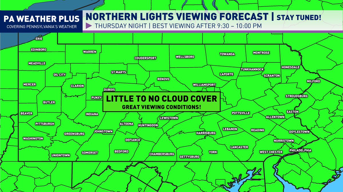
** POTENTIAL NORTHERN LIGHTS THURSDAY NIGHT **
The Northern Lights may be visible for the entirety of Pennsylvania (on the horizon) Thursday night with potential G3 solar storm conditions. Here is the cloud viewing forecast for tonight. The cloud outlook appears more favorable for many locations, as we will see mostly clear skies with some areas of high-level clouds that shouldn't hinder viewing.
Keep in mind, aurora forecasting is very difficult, and it is not a guarantee that it will occur tomorrow night. As of right now, the SWPC does hint at a G3 solar storm. It is still not a guarantee we will see auroras in Pennsylvania, but it is looking quite possible.
**Travelling long distances is not recommended (high risk, although high reward). **
If this storm occurs, all of PA will see these auroras. To be able to see the auroras, you will need a good view of the northern horizon, away from heavy light pollution. **YOU WILL NOT SEE AURORA IN HIGH-LIGHT POLLUTION REGIONS.** Smartphones & digital cameras will best pick up on the Northern Lights. Your eyes will need to adjust to the dark for at least 30 minutes as well. The best time will be after 9:30-10:00 pm or whenever the last light on the horizon disappears at your location.
I will continue to provide updates and let you know the latest details on this potential geomagnetic storm.
Stay tuned for updates!
#PAwx #Pennsylvania #Aurora #NorthernLights
** RETURN OF THE 90S BY THE END OF THE WEEK **
With us now in the month of June, the heat will come as no surprise as summer arrives across the region. Temperatures will slowly warm up heading into the latter half of the week, with widespread 80s and low 90s returning as soon as Friday. Saturday will feature similar temperatures, if not a tad warmer in some of the southern locations. There will be the risk of thunderstorms as we head into Saturday night and throughout the day on Sunday. Stay tuned!
Pennsylvania Weather Daily
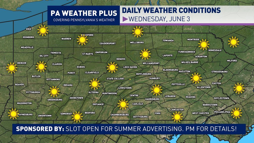
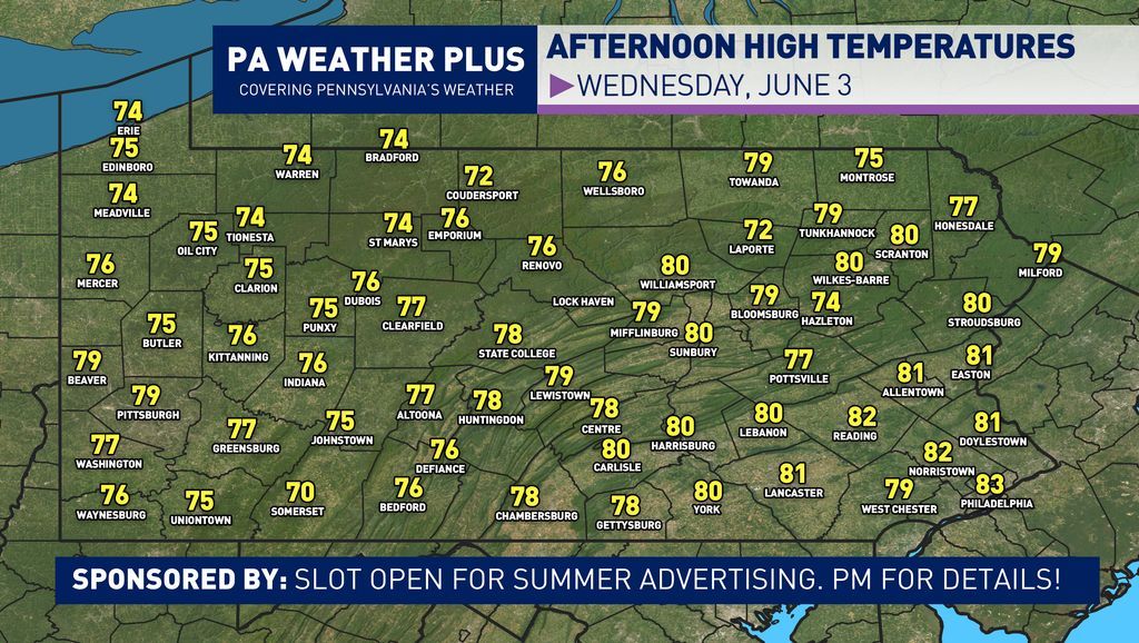
☀️ Wednesday, June 3
Good morning, Pennsylvania, happy Wednesday! Wow, we have a wonderful day on tap across the Commonwealth as high temperatures climb into the mid 70s to low 80s for most locations under sunny skies. It is not often we see comfortable temperatures/humidity overlap with mostly sunny skies, so if you can, make sure to get outdoors and soak in the sunshine! Temperatures continue to climb as we head into Thursday, Friday, and Saturday, with possible storm chances throughout the weekend.
Stay tuned for updates!
#PAwx #Pennsylvania #Sun #June #Summer #Warmth #Meteorology #Weather
** RETURN OF THE HEAT TO END THE WEEK **
With us now in the month of June, the heat will come as no surprise as summer arrives across the region. Temperatures will slowly warm up heading into the latter half of the week, with widespread 80s and low 90s returning as soon as Friday. Saturday will feature similar temperatures, if not a tad warmer in some of the southern locations. There will be the risk of thunderstorms as we head into Saturday night and throughout the day on Sunday. Stay tuned!
** PENNSYLVANIA 7-DAY UPDATED OUTLOOK **
As we head into the middle and end parts of the week, we will see a slow warming trend into the 80s and low 90s with dry conditions holding. It will be a great time to get outdoor plans done, and with temperatures warming well above average, the lakes and pools across the state may finally warm up!
WEEKEND PREVIEW: The peak of the heat looks to occur on Friday/Saturday for most locations, especially along and south of I-80. High temperatures will rise into the low 90s for cities such as Harrisburg and Philadelphia. Moving into Saturday, a slow-moving front will begin to move in from the north, which will allow for PM scattered thunderstorm chances. Right now, Saturday nor Sunday appear to be a total washout. Sunday will offer a better chance for showers and storms as more boundaries will push into the midst of the state. Severe weather is possible given the amount of instability with the heat.
A lot of uncertainty remains as we head into the first few days of next week. One scenario will allow the front to clear, which will allow for seasonable temperatures and mostly sunny skies. The second scenario will give the front to stall, allowing for drenching downpours to continue into Monday and Tuesday with cooler temperatures. I am going in the middle now, right with precipitation chances for both days and near-seasonable temperatures. We will see how this progresses with trends over the next few days.
Stay tuned for updates! #PAwx #Pennsylvania #Weekend #WeeklyForecast #Meteorology #Weather #Summer #June
Pennsylvania Weather Daily
⛅ Tuesday, June 2
Good morning, Pennsylvania, happy Tuesday! We have another wonderful day on tap with high temperatures ranging from the upper 60s to mid 70s for most locations under a mix of sun and clouds. It will be a rather comfortable afternoon to get outdoors and to enjoy the sunshine! What are you planning to do to make the most of this wonderful Tuesday? ☀️
Temperatures will continue to rise throughout the week, peaking in the mid 80s to low 90s on Friday and Saturday. Stay tuned for updates!
#PAwx #Pennsylvania #Sunshine #Clouds #Weather #Meteorology
Pennsylvania Weather Daily
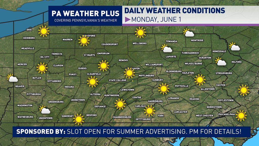
☀️ Monday, June 1
Good morning, Pennsylvania, happy Monday, and happy first day of June! June marks the first day of meteorological summer and the first day of the 2026 Atlantic Hurricane Season. It is expected to be a rather beautiful day with plenty of sunshine and comfortable temperatures. Temperatures will be right around average to just a bit below average in some spots. We will see temperatures climb throughout the week, with many areas climbing into the 80s by Thursday and Friday. Stay tuned! ☀️
#PAwx #Pennsylvania #June #Meteorology #Summer #Sunshine
** WEEKLY CITY-BY-CITY OUTLOOK **
Overall, we have a quieter and milder week ahead of us as we are currently stuck in a drier-than-normal weather pattern. High temperatures will generally be in the upper 60s to mid 70s through the middle of the week. As we get past Wednesday, we will see the pattern shift a bit with our winds coming out of the south, allowing for a warmup into the 80s for most locations. ☀️
The weekend right now looks to be uncertain, as we could have multiple boundaries move into the state. With the increase in heat and humidity, I added storm chances due to these potential boundaries. If you have any weekend plans, while right now it is too early to tell exact details, but I would expect there to still be a lot of dry time, and a washout anywhere is currently not expected in any location. If you have weekend plans, make sure to check back for updates throughout the week! ⛈️
How do you feel about the upcoming pattern this week? Stay tuned for updates! #PAwx #Pennsylvania #June #Summer #Thunderstorm #Sunshine
Pennsylvania Weather Daily
☀️ Sunday, May 31
Good morning, Pennsylvania, happy Sunday, and happy last day of May! We have a beautiful day on tap, with most locations around the average or just a few degrees below. With a mostly sunny day in store, it will be a BEAUTIFUL day to get outdoors, and maybe jump in a pool/lake for the first time in a while. What are you planning to do to make the most of this sunny and warm Sunday? ⛅☀️
#PAwx #Pennsylvania #Weather #Meteorology #Sunday #Sunshine #Warm
Pennsylvania Weather Daily
☀️ Saturday, May 30
Good morning, Pennsylvania, happy Saturday! Overall, it will not be a terrible day across the state, at least compared to Saturday a week ago. We will start out on the breezy side, with the strongest gusts expected in eastern Pennsylvania. These winds will slowly subside throughout the day. With our flow directly out of the north, it will be on the cooler side today, with high temperatures ranging from the upper 50s to low 70s northeast-to-southwest. It will also be on the sunny side with intervals of clouds in the eastern portions of the state.
Sunday will be even better with plenty of sunshine, with high temperatures climbing into the low 70s for pretty much the whole state. At the end of the day, despite the "chill" today in some parts of the state, it is expected to be a wonderful weekend for outdoor plans!
What are you planning to do outdoors today? Anyone making up plans for the rain/chill we had last weekend for the holiday?
#PAwx #Pennsylvania #Weather #Sunshine #May
** WATCHING FOR INCREASED WIND GUSTS SATURDAY MORNING / EARLY AFTERNOON **
While these are "typical" winds for the wintertime, as we head into summer, it becomes quite unusual to see consistent strong wind gusts outside of strong thunderstorms, especially coming out of the north. This is due to a low-pressure system that will be diving out of the Arctic and into New England, allowing for a tight pressure gradient between the high pressure to our west. In fact, this anomalous system will bring some snow to portions of Maine and New Hampshire!💨🍃
The strongest wind gusts will be over eastern Pennsylvania, with a few gusts up to 40 - 45 mph not ruled out. The farther west you are located, the fewer wind gusts you will see. Given the vegetation and heavily leafed trees, a few power outages cannot be ruled out in far eastern Pennsylvania, especially in areas that are more prone to limb/tree damage.
The worst of the wind will fall between 6 AM and 2 PM as the winds will quickly ease into the evening. High temperatures will be 10 to 15 degrees below normal for much of the state tomorrow, outside of far southwestern Pennsylvania (5 - 8 below normal). At least it will be a mostly dry day, right?! ☀️
With many other local weather pages going with hyperbolic AI weather posts, based on the poll two weeks ago, you can count all PA Weather Plus graphics will be AI-free and handmade with top tier accuracy!
Pennsylvania Weather Daily
☀️Friday, May 29
Good morning, Pennsylvania, happy Friday! We have a beautiful expected end to the week as high temperatures climb into the 70s for most locations under mostly sunny skies. Enjoy the milder and calmer conditions today as we have major changes to the weather pattern to come tomorrow. A low-pressure system moving out of the Arctic will move into the Northeast, bringing with it strong wind gusts and much colder. Luckily, we won't be dealing with the snow that is expected in the higher elevations of Maine and New Hampshire.
SATURDAY STRONG WIND GUSTS: We are usually not used to these type of strong, gusty winds outside of the winter from synoptic systems. The wind will be quite breezy to borderline strong in portions of eastern Pennsylvania. With leafed trees, expect possibly some downed trees/branches with isolated power outages.
Pennsylvania Weather Daily
🌤️ Thursday, May 28
Good morning, Pennsylvania, happy Thursday! We have a rather seasonable day on tap, but a bit on the cooler side in the northern regions. High temperatures will range from the low 60s to the low 70s this afternoon. It is expected to be a mainly dry day with a few clouds across central/eastern PA. A random isolated quick shower cannot be ruled out in the late afternoon in central or eastern PA, but 95% of the state will hold dry today.
** BLAST OF WEEKEND COOLER AIR **
A blast of cold air will move into the Northeast right in time for the weekend, impacting our weather here in Pennsylvania. While the worst of the cold likely stays in New England, where high temepratures may be as much as 30 degrees below average and even bring some high-elevation snowfall, here back home we will still feel the chill with high temperatures 10 to 15 degrees below normal.
Right now, while it will be chilly, it is likely looking to be on the drier side (outside of an iso. shower in far northern/northeastern PA). High temperatures right now look to be in the upper 50s in northern Pennsylvania and slowly rise to the mid-upper 60s as you head toward southern Pennsylvania. Sunday will be several degrees warmer, into the mid-60s to low 70s.
While it won't be a great weekend for swimming, these are rather comfortable temperatures to get yard work finished and do some hikes before the peak of summer heat builds back in sooner than later (plus, it will be a mostly dry weekend)! ☀️
Pennsylvania Weather Daily
🌧️Wednesday, May 27
Good morning, Pennsylvania, happy Wednesday! A stationary front will lift north today, which will allow for some wet weather to track into the state. While it is not expected to be a total washout, expect to dodge some raindrops, especially the farther south you are located. It will be a warm/humid day with high temperatures climbing into the mid 70s to low 80s for most locations. It will feel a bit muggy as well, with dew points climbing into the mid 60s for many.
AREA A: Showers likely with a few rumbles of thunder through the morning and into the afternoon. Some downpours could be on the heavier side and produce a risk for flash flooding (primarily in far southwestern PA).
AREA B: A shower or two possible in the morning, with a slightly higher chance in the afternoon. Nevertheless, these showers will be on the spottier side, and most locations should fare out on the drier/cloudy side.
Stay tuned and stay dry today! #PAwx #Pennsylvania #Weather #Rain #Meteorology #Flood
⚠️ FLASH FLOODING RISK INCREASED FOR WEDNESDAY 5/27 ⚠️
A stationary front will lift north tomorrow, bringing the risk for heavier downpours and storms across far southwestern Pennsylvania. In response, the WPC has placed parts of the region under a flash flood risk (level 1/4 - green, level 2/4- yellow). Scattered flash flooding events are expected in the level 2/4(yellow). Flash flooding is expected in the heavy thunderstorms due to the recently saturated ground and high atmospheric moisture content. Thunderstorms may produce 1-2"+/hr rates this evening, which can lead to flash flooding. Flash flooding may occur as quick as minutes in the heaviest downpours. Remember to turn around, don't drown, and heed all flash flood alerts issued tomorrow. Stay tuned! #PAwx #Pennsylvania #FlashFlood #Flood
Pennsylvania Weather Daily
☁️ Tuesday, May 26
Good morning, Pennsylvania, happy Tuesday! We have a milder day on tap across the region, but not everyone will remain dry throughout the day. High temperatures will climb into the mid-to-upper 70s for most locations, but a stationary front to the south will allow for periods of cloud cover and even some showers into southern Pennsylvania during the afternoon hours.
AREA A: Watching for some spotty showers or even a rumble of thunder, primarily during the mid-to-late afternoon. An isolated heavier downpour can cause localized ponding of water, but widespread flash flooding and/or severe weather is currently not expected.
Stay tuned for updates! #PAwx #Pennsylvania #Rain #May #Showers #Spring