🍜🍢 THIS IS HOW FUKUOKA DOES LATE-NIGHT DINING! 🍻🍶
Only in 🇯🇵 can you watch a guy or gal roll an entire restaurant down the street, park it, unfold it, 🔥 up the kitchen, and start serving some of the best food around! 👨🍳🥢
Welcome to Fukuoka's legendary YATAI (屋台) — tiny mobile restaurants that are part street food, part neighborhood bar, and 100% Japanese charm. 🇯🇵🏮These little culinary wonders, found along the riverbanks 🌃 and tucked into busy city streets, have been around for generations, booming after World War II. Today, around 100 carry on the tradition. Fukuoka is one of the few places left in Japan where this wonderful street-food culture is still thriving! 🏮✨
And the best part? You squeeze onto a stool, rub elbows with complete strangers, order some sizzling ramen 🍜, yakitori 🍢, and maybe a little sake 🍶, beer 🍺, or a few Japanese highballs 🥃. Before you know it, everybody's your new best friend! 😂🥂
Forget the 24-hour drive-in. In Fukuoka, the restaurant rolls up on wheels! 🛞😂
⚾🏆 SOME OF THE BEST BASEBALL IN THE WORLD IS BEING PLAYED RIGHT HERE IN MY NEW HOMETOWN OF FUKUOKA, JAPAN! 🇯🇵
And I'm lucky enough to be experiencing it firsthand!
I WAS THERE LAST NIGHT! What an incredible finish to Game 3 of the Japan Series!
Tomoya Masaki blasted a dramatic walk-off home run against the Yokohama DeNA BayStars, sending the crowd at Fukuoka's PayPay Dome into absolute pandemonium!
The Hawks now lead the series 3–0, and tonight I'll be back at the Dome for Game 4, with a chance to witness something truly special — a championship-clinching victory and a sweep!
Since moving to Fukuoka, I've discovered just how passionate Japan is about baseball. The atmosphere is electric, the fans are incredible, and the quality of play is outstanding.
And my newly adopted hometown team isn't just good.
THE FUKUOKA SOFTBANK HAWKS ARE A DYNASTY!
Eight Japan Series championships since 2011, with a remarkable organization built around player development, depth and a winning tradition.
As The Japan Times recently reported, the Hawks have become the model of a modern baseball dynasty.
I've followed baseball my entire life, but there's something pretty special about moving halfway around the world and finding yourself cheering for one of the most dominant teams in the sport.
Tonight, I'll be back in the stands, hoping to watch my new hometown celebrate another Japan Series championship!
🦅⚾🏆 ONE MORE WIN! LET'S GO HAWKS!
🌪️ TYPHOON SAUDEL UPDATE — MONDAY, AUGUST 24, 2026 — 10:00 AM JST
There are now three active tropical cyclones in the Northwest Pacific — Typhoon Saudel (17W), Tropical Storm Narra (18W), and Tropical Depression 19W. But don't let the number alone create unnecessary alarm. They are very different systems.
🔴 SAUDEL REMAINS THE MAIN CONCERN
There has been no major change in Saudel's forecast track overnight. Okinawa and the Ryukyu Islands remain in the primary threat area Tuesday into Wednesday.
Saudel remains a powerful Category 3-equivalent typhoon, with:
🌬️ Sustained winds: 110 kt / 127 mph
💨 Gusts: 135 kt / 155 mph
🔻 Central pressure: 945 mb
🌊 Significant wave height: 48 feet / 15 meters
One thing worth watching is Saudel's expanding wind field. Typhoon-force winds now extend as far as 80 nautical miles from the center in the northeast quadrant, while tropical-storm-force winds extend as far as 170 nautical miles.
⚠️ OKINAWA & RYUKYUS
JTWC forecasts Saudel near 26.4°N, 130.2°E Tuesday afternoon, still producing sustained winds around 121 mph.
By early Wednesday it is forecast near 27.2°N, 128.3°E, with winds around 109 mph.
That keeps Okinawa and portions of the Ryukyus at risk for damaging winds, torrential rain, flooding, dangerous surf and extremely rough seas.
With the wind field this large, don't become overly focused on exactly where the center line crosses the islands.
🟢 KYUSHU
No bad surprise for Kyushu this morning.
The forecast continues to turn Saudel westward after it crosses the Ryukyu region and into the East China Sea. Kyushu remains well north of the projected center.
Southern Kyushu could still experience peripheral effects — particularly increased surf and seas, along with some rain and gusty winds — but a direct strike remains unlikely on the current track.
🇹🇼 TAIWAN & 🇨🇳 CHINA
Saudel is forecast to pass north of Taiwan before continuing westward toward China's coast while gradually weakening.
Northern Taiwan could still experience peripheral rain, wind and rough seas, so we'll continue watching that part of the forecast as well.
🌀 AND WHAT ABOUT 19W?
Yes, there's another tropical depression well south of Saudel, currently about 286 nautical miles north-northwest of Yap.
But right now there is no reason to hype it.
19W has winds of only about 35 mph, and JTWC currently forecasts it to weaken and dissipate over water by Tuesday.
There are three tropical cyclones on the board, but that doesn't mean three major threats.
For us, Saudel remains the storm to watch.
And as we learned with Dolphin, a little wobble can alter timing and keep impacts around longer than expected. We'll keep watching the actual motion rather than just the line on the map.
🌪️🇯🇵 Kyushu Weather Now
I’m writing regarding the recently published Phase 1 results for DYP688 in metastatic uveal melanoma. Northwell Health quoted Dr. Richard Carvajal as saying Novartis made a business decision to halt development of DYP688. Could you confirm when Novartis discontinued the DYP688 program, the reason for the decision, and whether the asset remains available for licensing or development by another party?
@Novartis
🌀 Update: Typhoon Dolphin Brings Destructive Winds to Okinawa; Eye Expected to Pass Just North
Updated: Friday 11:00AM (JST)
Typhoon Dolphin continues to impact Okinawa as a Category 1-equivalent typhoon, with the strongest conditions now spreading across the islands. The storm remains well-organized with sustained winds near 90 mph (145 km/h) and gusts up to 115 mph (185 km/h) near its center.
The U.S. military has now raised Okinawa to Tropical Cyclone Condition of Readiness (TCCOR) 1-E, the highest alert level, after destructive sustained winds of at least 58 mph (50 knots) began occurring on U.S. installations. Non-essential personnel have been ordered to remain indoors until the all-clear is given.
Satellite imagery indicates the eye is passing just north of Okinawa, keeping the most intense core slightly north of the island. However, dangerous weather continues across Okinawa with damaging wind gusts, torrential rain, rough surf, and coastal flooding possible. Conditions can still change quickly if the eyewall wobbles south.
🌬️ Strongest Winds So Far
Some of the strongest measured wind gusts have been across the Amami Islands in Kagoshima Prefecture, where gusts have reached 74.7 mph (120 km/h). Additional typhoon-force gusts have also been reported across parts of Okinawa.
🌦️ Impact on Kyushu
For Kyushu, the forecast remains much more favorable.
Mostly dry conditions for many areas.
A few passing showers, mainly across southern Kyushu.
Breezy conditions at times, especially along southern coastal areas.
Rough surf and dangerous rip currents along Pacific-facing beaches.
At this time, widespread damaging winds or heavy rainfall are not expected across most of Kyushu or mainland Japan.
⚠️ Stay Safe
If you are in Okinawa, remain indoors and avoid travel until local authorities declare it safe. Although the eye is forecast to stay just north of the island, dangerous conditions will continue as the storm passes and the backside of the circulation moves through.
Sources: Japan Meteorological Agency (JMA), Joint Typhoon Warning Center (JTWC), NOAA, and Stars and Stripes Pacific Storm Tracker.
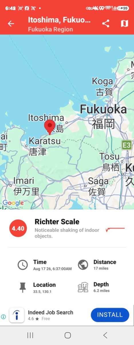
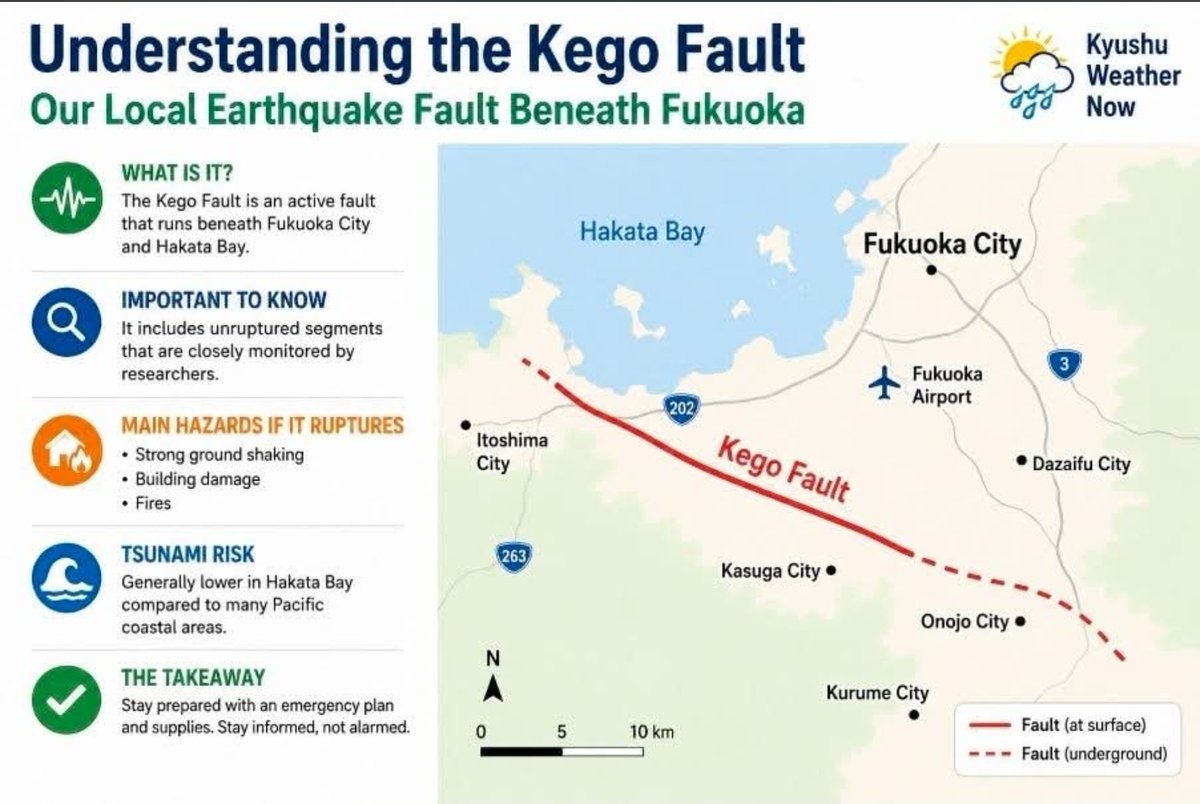
🌎 #Kego Fault: Our Local Earthquake Risk Explained
Whenever a major earthquake strikes Japan, attention naturally shifts to other well-known fault zones—including the Kego Fault beneath Fukuoka. That's understandable, but it doesn't necessarily mean the risk has suddenly changed.
Many longtime Fukuoka residents still remember the 2005 Fukuoka Prefecture Western Offshore #Earthquake (M7.0), which damaged buildings, injured hundreds of people, and served as a reminder that our region is not immune to earthquakes. While that event was associated with the Kego Fault system, the southeastern section beneath #Fukuoka City did not rupture and continues to be closely monitored by researchers.
According to Kyushu University seismologist Dr. Mitsuteru Asai, the recent Kumamoto earthquake likely occurred on a previously unruptured section of the Hinagu Fault. He noted that the southeastern section of the Kego Fault is also an unruptured segment that continues to be monitored.
Japan has thousands of mapped active faults, many with unruptured sections. That's not unusual—it's simply how fault systems evolve over time.
My old friend, seismologist Dr. Lucy Jones, always emphasized during my reporting days in Southern California that it's important to distinguish long-term earthquake hazards from short-term predictions. We still can't predict earthquakes, and a major quake in one area doesn't mean another fault is suddenly about to rupture.
While no place in Japan is earthquake-free, Fukuoka is generally considered to have a lower overall seismic risk than many other parts of the country, especially compared with regions along the Pacific coast near the Nankai Trough and Japan Trench. If a major earthquake were to occur on the Kego Fault, the primary hazards would be strong ground shaking, structural damage, and fires. Tsunami risk in Hakata Bay is generally lower than for many Pacific coastal communities.
Bottom line: Stay prepared, not alarmed.
https://t.co/gGstVEEJs4
@nhk_newsoon Hello. I run a service in Kyushu Weather Now and desperately looking for one of your pointers for on-air fun. I'm glad to pay for any color if you can spare a few. Thank you
#kyushuweathernow[email protected]
☁️ No, That Isn't an "Earthquake Cloud."
Following yesterday's M7.1 Kumamoto earthquake, this dramatic cloud photo has gone viral, with some claiming it's evidence of an "earthquake cloud" (地震雲).
As impressive as it looks, this is simply a classic anvil-shaped cumulonimbus (thunderstorm) cloud. During Kyushu's hot, humid summers, strong updrafts can build towering thunderstorms. When they reach the tropopause—the upper boundary of the atmosphere—the cloud spreads outward, creating its familiar anvil shape.
Despite decades of stories and speculation, there is no credible scientific evidence that cloud formations can predict or are caused by earthquakes. The timing of this cloud and the earthquake was almost certainly coincidental.
Beautiful? Absolutely. Rare? Not really. A sign of an earthquake? No.
— Pablo Pereira
Certified Meteorologist | Kyushu Weather Now 🌦️
Earthquake! 7.1
South Kyushu. Did you feel it? I did, but nothing this LA Boy hasn't seen before😉
A magnitude 7.1 earthquake has struck Kumamoto Prefecture, registering up to "shindo" 7, the highest level on the Japanese seismic intensity scale. The weather agency issued a tsunami alert, urging people to stay away from the ocean and the sea shore.
Kyushu Electric Power says it has not yet found any abnormalities at either the Genkai Nuclear Power Station in Saga Prefecture or the Sendai Nuclear Power Station in Kagoshima Prefecture.
It also says radiation levels around the stations have not changed.
https://t.co/DhnG5oioSV
https://t.co/xNSF69Zc4W
💙 Help Reach 1,000 Rare Eye Cancer Patients Every Day
📱 Scan this QR code to join—or share it with another #ocularmelanoma patient, caregiver, doctor, or support group.
Go beyond the headlines by simplifying complex research, explaining treatments in plain English, and answering the questions many wished they known to ask.
One scan. One new member. One more patient helped. 💙
Heads up California !
A major property tax increase on the ballot. State Lawmakers are trying to repeal Prop 13 by slipping it under the radar.
They know it will be unpopular if presented as
"Repeal Prop 13," so it has strategically been relabeled as "Education and Local Government Funding." It's already on the 2026 ballot and like the gasoline tax, it will be worded in a way that misleads California voters.
Vote NO on Education and Local Government Funding!!!!!!
All my California friends and family, please COPY and REPOST as this must be defeated.
This is a crime against all Californians! Stop it now! 😡
🇲🇽⚽🍻 LIVE from Papas & Beer in Ensenada! 🌊🌮🎉
This place is absolutely INSANE! 🤯 The crowd is already singing 🎶, chanting 📣, waving flags 🇲🇽, and raising their beers 🍺🍻...
...and kickoff hasn't even happened yet! 😳
There was plenty of tension leading into this match. Reports say loud crowds outside Ecuador's hotel in Mexico City kept the team awake overnight. 🇪🇨 Ecuador's response? 💬 "We'll settle it on the field." ⚽💪
Now it's game time. ⏰ This feels like Mexico's Super Bowl! 🇲🇽🏆🍻🔥
🌏🇯🇵KYUSHU WEATHER NOW - TUESDAY JUNE 2, 2026 UPDATE 📅
🌧️ FORMER TYPHOON JANGMI MOVING AWAY — IMPACTS CONTINUE ACROSS SOUTHWEST JAPAN
While Former Typhoon Jangmi continues pulling away from Okinawa and Kyushu, its impacts are still being felt across southwestern Japan. Authorities report at least 9 injuries in Okinawa, while tens of thousands of homes remain without power across Okinawa and Kagoshima Prefectures.
Rain bands continue across much of Kyushu this afternoon, particularly over southern and eastern areas, but conditions are expected to improve steadily from west to east later today.
TUESDAY AFTERNOON 🌧️ Periods of rain continue across much of Kyushu. 🌧️ Locally heavy downpours remain possible in Kagoshima, Miyazaki and parts of Oita. 🌥️ Western areas including Nagasaki and Sasebo may begin seeing improving conditions later today.
TUESDAY HIGH TEMPERATURES 🌧️ Fukuoka: 24°C / 75°F 🌧️ Kitakyushu: 24°C / 75°F 🌧️ Saga: 25°C / 77°F ⛅ Sasebo: 26°C / 79°F 🌧️ Nagasaki: 25°C / 77°F 🌧️ Kurume: 24°C / 75°F 🌧️ Kumamoto: 26°C / 79°F 🌧️ Oita: 23°C / 73°F 🌧️ Miyazaki: 25°C / 77°F 🌧️ Kagoshima: 26°C / 79°F
🏝️ OKINAWA / NAHA ☀️ Naha: 28°C / 82°F
Sunshine has returned to Okinawa as the storm departs, although recovery efforts continue.
⚡ STORM IMPACT UPDATE • At least 9 people injured in Okinawa according to Japanese officials. • More than 17,000 homes remain without power in Okinawa. • Approximately 32,000 customers remain without electricity in Kagoshima Prefecture. • Hundreds of flight cancellations continue to affect travel across Japan.
WEDNESDAY ☀️ Sunshine returns to most of Kyushu. 🌡️ Temperatures rebound into the upper 20s and lower 30s. 😎 Much more pleasant weather expected region-wide.
THURSDAY ☀️ Mostly sunny and dry. 🌡️ Warm afternoons and lower humidity.
BEYOND MIDWEEK 🌤️ High pressure builds over western Japan with a quieter weather pattern expected through the remainder of the week.
🚗 TRAVEL WEATHER IMPACTS • Wet roads and reduced visibility continue today. • Rough seas and ferry disruptions remain possible. • Residual airline delays and cancellations may continue into Wednesday. • Significant improvement expected by Wednesday afternoon.
📘 Kyushu Weather Now | AMS Certified Meteorologist Pablo Pereira 🇯🇵🌏
🌏🇯🇵KYUSHU WEATHER NOW - TUESDAY JUNE 2, 2026 UPDATE 📅
🌧️ FORMER TYPHOON JANGMI MOVING AWAY — IMPACTS CONTINUE ACROSS SOUTHWEST JAPAN
While Former Typhoon Jangmi continues pulling away from Okinawa and Kyushu, its impacts are still being felt across southwestern Japan. Authorities report at least 9 injuries in Okinawa, while tens of thousands of homes remain without power across Okinawa and Kagoshima Prefectures.
Rain bands continue across much of Kyushu this afternoon, particularly over southern and eastern areas, but conditions are expected to improve steadily from west to east later today.
TUESDAY AFTERNOON 🌧️ Periods of rain continue across much of Kyushu. 🌧️ Locally heavy downpours remain possible in Kagoshima, Miyazaki and parts of Oita. 🌥️ Western areas including Nagasaki and Sasebo may begin seeing improving conditions later today.
TUESDAY HIGH TEMPERATURES 🌧️ Fukuoka: 24°C / 75°F 🌧️ Kitakyushu: 24°C / 75°F 🌧️ Saga: 25°C / 77°F ⛅ Sasebo: 26°C / 79°F 🌧️ Nagasaki: 25°C / 77°F 🌧️ Kurume: 24°C / 75°F 🌧️ Kumamoto: 26°C / 79°F 🌧️ Oita: 23°C / 73°F 🌧️ Miyazaki: 25°C / 77°F 🌧️ Kagoshima: 26°C / 79°F
🏝️ OKINAWA / NAHA ☀️ Naha: 28°C / 82°F
Sunshine has returned to Okinawa as the storm departs, although recovery efforts continue.
⚡ STORM IMPACT UPDATE • At least 9 people injured in Okinawa according to Japanese officials. • More than 17,000 homes remain without power in Okinawa. • Approximately 32,000 customers remain without electricity in Kagoshima Prefecture. • Hundreds of flight cancellations continue to affect travel across Japan.
WEDNESDAY ☀️ Sunshine returns to most of Kyushu. 🌡️ Temperatures rebound into the upper 20s and lower 30s. 😎 Much more pleasant weather expected region-wide.
THURSDAY ☀️ Mostly sunny and dry. 🌡️ Warm afternoons and lower humidity.
BEYOND MIDWEEK 🌤️ High pressure builds over western Japan with a quieter weather pattern expected through the remainder of the week.
🚗 TRAVEL WEATHER IMPACTS • Wet roads and reduced visibility continue today. • Rough seas and ferry disruptions remain possible. • Residual airline delays and cancellations may continue into Wednesday. • Significant improvement expected by Wednesday afternoon.
📘 Kyushu Weather Now | AMS Certified Meteorologist Pablo Pereira 🇯🇵🌏