Quickly map address or coordinate data and visualize it on a map directly in @Microsoft#Excel, with the #ArcGIS for Excel add-in. https://t.co/TIpxZNkG5X
By using #aerialimagery, staff at Shaw Vineyards can now identify and fix #irrigation leaks quickly, resulting in a more uniform vine canopy. https://t.co/B6v3wGRR0I #startup@pollensystems
How does #plastic get into the ocean? In this video, a @NatGeo Explorer reveals her creative method of tracking the origins of #ocean plastics https://t.co/LQCfaZz8TF #GIS#NatGeoExplorer
In #Alaska, time is a critical factor for #construction projects. Learn how the @chugachelectric used #GIS to efficiently plan and execute their work productively during the short five-month construction season. https://t.co/pnvmENr9ml
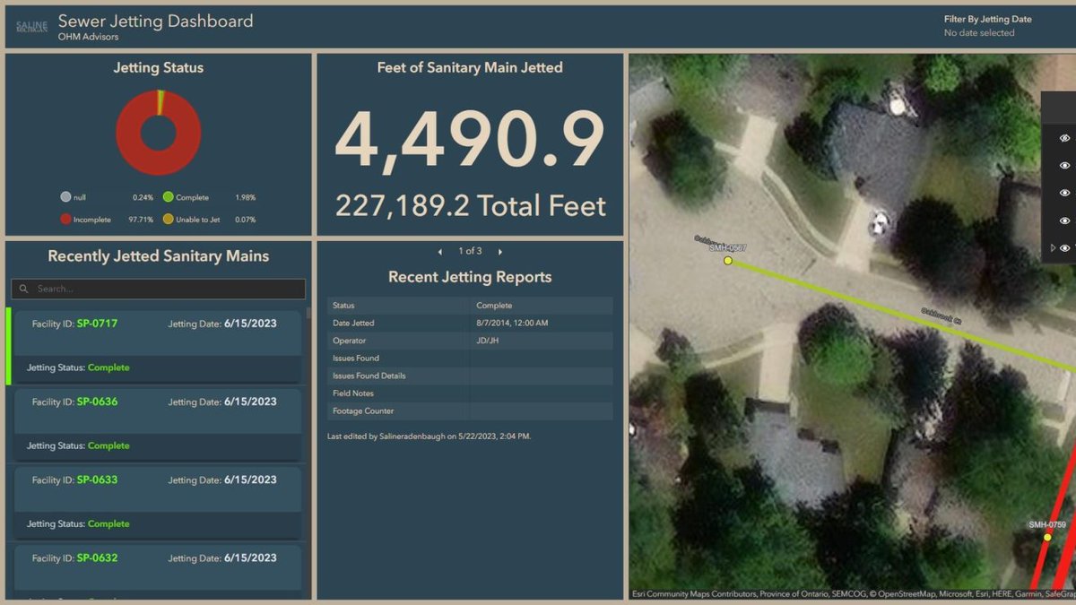
For the @CityofSaline, Michigan, a #utility master plan and #GIS go hand in hand. GIS helps the city to track work, reduce costs, and plan #publicworks investments for years into the future. https://t.co/tZs4Pow7yD @EosGNSS
When a big #storm or #extremeweather is coming in your direction, predictive knowledge of possible impacts is essential for business operations. Read now @Forbes https://t.co/YCrR1gzZ5Y
With the integration of @Esri and @Microsoft's #SharePoint, the #Connecticut DOT captures all the information from their common data environment projects, creating a project repository that stands alone among #DOTs. https://t.co/fimEKH77AD
By leveraging Esri's mapping, dashboards and storytelling tools, the @arborday has improved its project selection processes, measured impact, and provided overall guidance for its work. https://t.co/kUIJMKzNcB
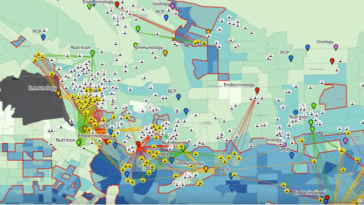
Use #ArcGISKnowledge to improve #healthcare accessibility. Many agencies adopt early intervention strategies to reduce #diabetes. #Mapping when, where, and why these strategies face community barriers can change diabetes outcomes. https://t.co/8X5PTIiE71
Liberty Utilities is unique, with no contiguous service territories. They selected @Esri's #ArcGIS for its enterprise #GIS solution and ArcGIS #Utility Network for #networkmanagement in the @Azure#cloud. https://t.co/i29w7zfC5X
The American Public Works Association’s annual Public Works Expo begins August 27 in San Diego. Here is a list of the sessions that Esri staff will be delivering. As always, #Esri will anchor the #GIS Pavilion at booth 2133. https://t.co/10AVnVocMw #PWX2023#APWA
How one email changed so much: @r_ahasan Esri 2023 intern and Geography Ph.D. candidate, candidly reflects on his summer internship with the #ArcGISPro team examining the spatial and temporal variations in #urbanheatisland effects. https://t.co/OOloWithLx #SummerInternship
Investigating a multistate criminal network with #ArcGIS AllSource. Learn how #AllSource works with the National Integrated Ballistic Information Network (NIBIN) and the U.S. @ATFHQ to help trace and reduce crimes across state lines https://t.co/m5YvxWWlEk
Esri Chief Scientist @deepseadawn again sounds a clarion call to action in @MongabayOrg: To protect the #oceans, we must #map them. https://t.co/30we3UG33J