Creator of the Cambodian-Thai Border Conflict Map
Senior Geolocator at @FaytuksNetwork
Views are entirely my own, likes/retweets/followings ≠ endorsement
31.52431, 34.45619
On 7 June 2026, an Israeli airstrike hit a vehicle in western Gaza city, in a claimed targeted assassination.
You can view the map of this geolocation and other events in the Middle East at: https://t.co/5jXocLJp6o
@FaytuksNetwork@GeoConfirmed
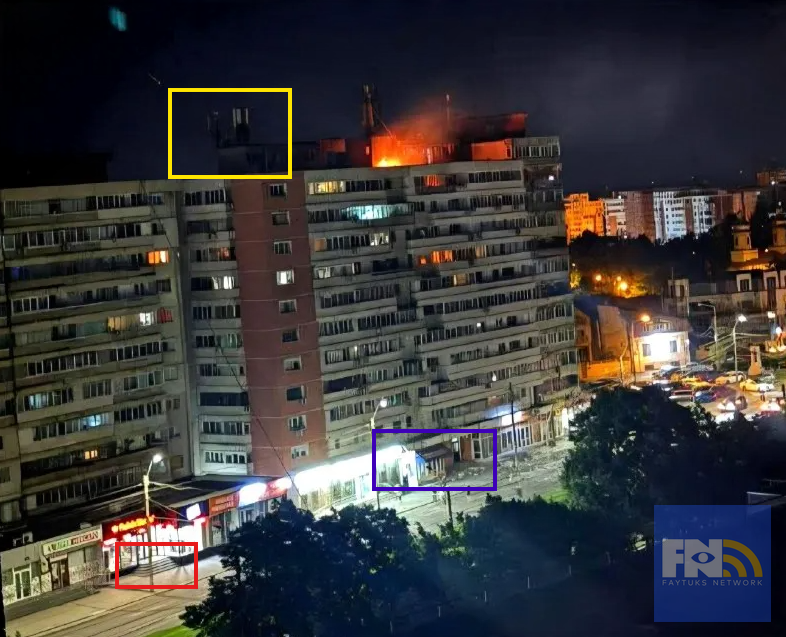
50.50661, 30.42932
A rocket strike damaged a residential building in Vynohradar, Kyiv. This part of Kyiv has not been regularly hit since the full-scale invasion of Ukraine began.
@FaytuksNetwork@GeoConfirmed
Thank you to a FN contributor for help with the geolocation.
33.88495, 35.49768
On 1 June 2026, a Lebanese gendarmerie checkpoint was set up in Beirut, Lebanon.
View the map of this geolocation and other events in the Middle East at: https://t.co/5jXocLJp6o
@FaytuksNetwork@GeoConfirmed
h/t @LayBayLT
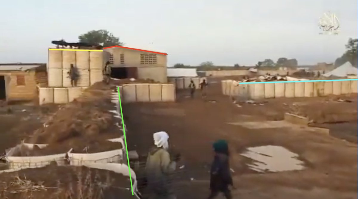
🇧🇯 #Benin: JNIM attacked two Beninese Army (FAB) camps in Koualou, Atakora, on May 25.
📌 Geolocation of camp #1: (11.034898, 0.932446) https://t.co/cL0Tst2phK
📌 Geolocation of camp #2: (11.029286, 0.928088)
https://t.co/D0k116O0rn
‼️با هدف رفع تهدید علیه نیروهای ما: ارتش اسرائیل انبارهای تسلیحاتی سازمان تروریستی حماس را منهدم کرد
⭕️نیروهای ارتش اسرائیل تحت فرماندهی جنوب، با استفاده از نیروی هوایی، در طول هفته سه انبار تسلیحاتی متعلق به سازمان تروریستی حماس را در چندین منطقه در نوار غزه هدف قرار داده و منهدم کردند. در این انبارها مواد انفجاری، سلاحهای سبک، تفنگهای تکتیراندازی و تجهیزات رزمی دیگر نگهداری میشد. در یکی از این انبارها حدود ۱۰ وانت که توسط سازمان تروریستی حماس برای فعالیتهای نظامی استفاده میشد، منهدم شد.
⭕️این تسلیحات برای آسیب رساندن به نیروهای ارتش اسرائیل که در منطقه خط زرد فعالیت م��کنند و همچنین شهروندان اسرائیل در نظر گرفته شده بود و بهمنظور رفع ��ین تهدید منهدم شدند.
⭕️پس از این حملات، انفجارهای ثانویهای شناسایی شد که نشاندهنده وجود تسلیحات در داخل این انبارها بود.
‼️ پیش از این حملات، اقداماتی برای کاهش آسیب به غیرنظامیان انجام شد، از جمله استفاده از مهمات دقیق و رصد هوایی.
⭕️نیروهای ارتش اسرائیل تحت فرماندهی جنوب مطابق با توافق در منطقه مستقر هستند و به فعالیت خود برای رفع هرگونه تهدید فوری ادامه خواهند داد
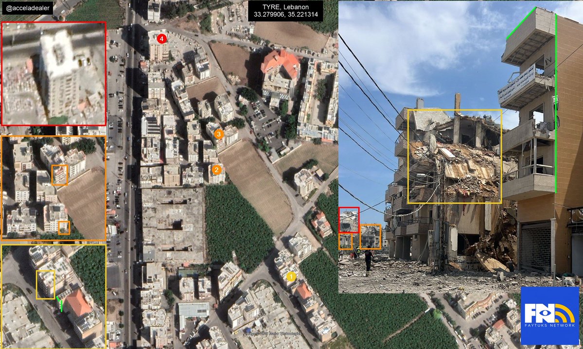
33.28014, 35.22152
On 31 May 2026, an Israeli airstrike destroyed a claimed Hezbollah headquarters in Tyre, Lebanon.
View the map of this geolocation and other events in the Middle East at: https://t.co/5jXocLJp6o
@FaytuksNetwork@GeoConfirmed
h/t @acceladealer
Heavy damage and partial collapse of multiple mid and high-rise buildings seen in TYRE, Lebanon
POV: 33.279906, 35.221314
Building 1: 33.280105, 35.221422
Building 2: 33.281523, 35.221535
Building 3: 33.281881, 35.221844
Building 4: 33.283005, 35.221937
@GeoConfirmed@FaytuksNetwork
geolocated by @acceladealer
33.41489, 35.47181
At 6 am on 30 May 2026, an Israeli drone strike hit a pickup truck on the Haboush - Deir al-Zahrani highway in Habbouch, Lebanon.
View the map of this geolocation and other events in the Middle East at: https://t.co/5jXocLJp6o
@FaytuksNetwork@GeoConfirmed
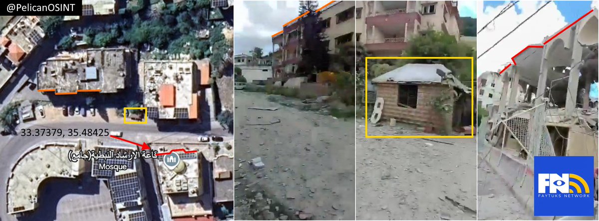
33.37379, 35.48425
On 28 May 2026, An Israeli airstrike heavily damaged the Guidance Hall in Nabatieh, Lebanon.
View the map of this geolocation and other events in the Middle East at: https://t.co/5jXocLJp6o
@FaytuksNetwork@GeoConfirmed
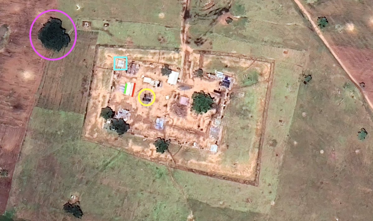
13.61714, 102.61011
Thai forces built a bunker in Poipet, approximately 200 m into Cambodian territory. According to Sentinel satellite imagery, the bunker was built between 28 and 30 March 2026.
@FaytuksNetwork@Nrg8000
You can view the map here: https://t.co/X9uBDjnAeI
Destruction of entire low-rise building (claimed IAF strike on Hezbollah headquarters) in TYRE, Lebanon
33.270614, 35.217717
@GeoConfirmed@FaytuksNetwork
source: https://t.co/vyvG1DNbE1
geolocated by @acceladealer
Faytuks Network Geo-Int team members have been hard at work mapping various conflicts around the world. Here is their most recent, a control map tracking events in Nigeria
https://t.co/7X8rVbqqsH