⚠️🔥 One day left of the oppressively hot and humid conditions. A few severe storms will be possible again this afternoon and evening, but not everyone will get a storm. It will turn much less humid for Saturday, but high temperatures will remain in the upper 80s to near 90°.
The transient cooling of the upwelling response to the recent relatively weak MJO-associated surge in the Pacific trade winds is now evident, with the ocean returning to the warmed state after the linear upwelling wave passes. The new westerly phase is also beginning to kick in.
@tjj710 I can't strip down any more naked than I already am. When I step outside for 3 minutes every orifice in my body is dripping sweat.
At least in the winter I can layer up
⚠️🥵⛈️ The hottest heat indices so far this year are expected today, topping out near 100° this afternoon in most areas. Near record breaking highs in the low to mid 90s. A Heat Advisory remains in effect through Friday for portions of the area. #PAwx#NJwx#DEwx#MDwx
Part of the super El-Nino battle in the weather community is the fact that it will lead to a much slower tropical storm season and some people just don't want to hear that
⛈️ Scattered showers and storms are forecast to develop this afternoon and evening. A few storms could be strong to severe, with locally damaging winds and brief heavy downpours possible. #PAwx#NJwx#DEwx#MDwx
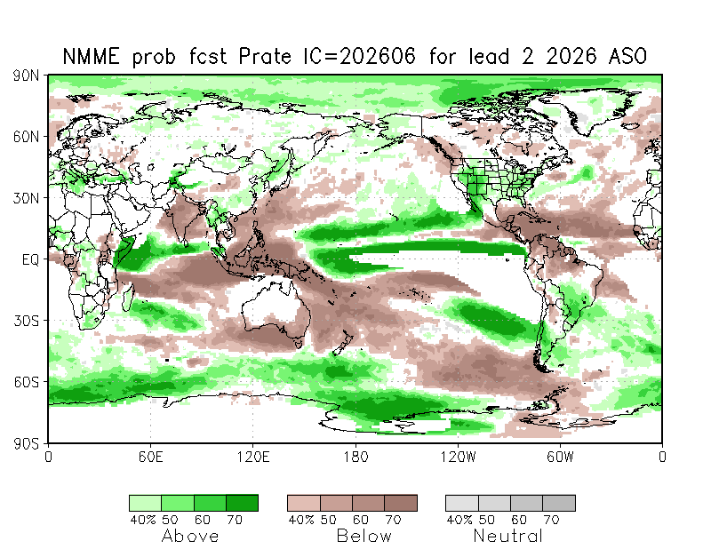
No surprises in the latest NMME climate model output. Niño intensity has ticked up in a few of the models (the CanESM5 was one of the last moderate Niño holdouts last month but it's all in on a near-record event now). I think the NCAR CESM1 broke or something this month.
The response looks extremely classic too. Wet anomalies across the tropical Pacific, with the NE and Central Pacific also active thanks to the +PMM. The Atlantic will be dry and hostile for basically the whole season, with drought possible in the Caribbean. The Gulf Coast will likely have a wet and stormy winter as the subtropical jet gets cranking.
Good Morning! Much more tranquil weather for today with temperatures cooler than yesterday. As a cold front passes, a few showers can't be ruled out, especially near the coast, but nothing like yesterday. #NJwx#PAwx#MDwx#DEwx
4 PM UPDATE: The risk of severe weather through this evening has further increased. Scattered to numerous severe storms capable of producing significant wind gusts are now possible.
Continue to stay weather alert through this evening.
#NJwx#PAwx#MDwx#DEwx
4 PM UPDATE: The risk of severe weather through this evening has further increased. Scattered to numerous severe storms capable of producing significant wind gusts are now possible.
Continue to stay weather alert through this evening.
#NJwx#PAwx#MDwx#DEwx
Looks like a fairly organized cluster out in western PA will be our main show this evening. It will be headed into a favorable environment in central PA with elevated CAPE and moderate lifted index.
Still looking pretty solid as a mid-month jet extension. Generally associated with cooler weather in the east. But the snap back may lead to hotter weather.
There is increased confidence that some strong to severe thunderstorms may make it as far southeast as the I-95 urban corridor Saturday evening. The primary threat with any severe storms remains damaging wind gusts. #PAwx#NJwx#DEwx#MDwx
This is probably the biggest Pacific Jet extension I’ve ever seen in June & it isn’t surprising to see as we discussed several days ago.
Buckle up…