Finally sarado na din ang kwento. Matagal naman na din kasing obvious na wala na talaga. Buti matagal ko ng tinanggap ang katotohanan kaya di na nakakabigla. Ganyan talaga ang buhay di para sa lahat ang salitang FOREVER.
Parang nakakapagtaka lang yung narration ng story kasi bakit alam lahat ng convo in details ng both sides? Ano yun human cctv or hightech yung radar? Or my invisible na sugong tagapagbantay sa bawat sides na taga kalat ng chikaness🤔
Daming may alam dito sa buhay ng may buhay kalahi yata ni Casper at nakakalusot sa dingding ng mga lugar kaya alam lahat ng kwento na imagination lang or napanaginipan lang nila🙄
Sabi na eh yung nagkakalat ng chismis eh supporter nung insecure na peyborit ng mga kataas taasan. Malamang malaki din ang pasobre sa kanya kaya todo promote sa idolet at todo bash dun sa pinanggigigilan nila.
True naman kasi na talagang insecure dati pa. Now nga feel na feel na ontop kasi laging laman ng mga balita. Dami pa din kasing naniniwala na totoong kaawa awa sa nangyaring sitwasyon na planado naman para makakuha lang ng atensyon at simpatiya.
@krierts Ngayon nga lang ako nakakita ng may pag bati pa ang Ex BF pero may papuso pa tapos sumagot din yung ex GF ng may papuso din ganun ba talaga pag break na 🤔
TROPICAL CYCLONE BULLETIN NO. 5
Typhoon #BettyPH (MAWAR)
Issued at 5:00 AM, 28 May 2023
Valid for broadcast until the next bulletin at 11:00 AM today.
TYPHOON “#BettyPH” MAINTAINS ITS STRENGTH WHILE MOVING OVER THE PHILIPPINE SEA EAST OF NORTHERN LUZON
https://t.co/iqWDkvVJK6
TROPICAL CYCLONE ADVISORY NO. 6
Super Typhoon “MAWAR”
Issued at 11:00 PM, 26 May 2023
Valid for broadcast until the next advisory at 11:00 AM tomorrow.
SUPER TYPHOON “MAWAR” SLIGHTLY WEAKENS AS IT CONTINUES TO APPROACH THE PHILIPPINE AREA OF RESPONSIBILITY (PAR)
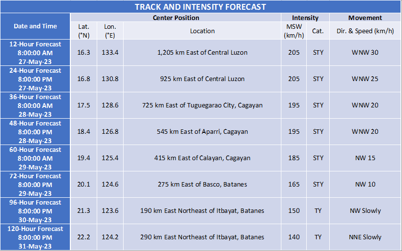
Location of Center (10:00 PM)
The center of the eye of Super Typhoon “MAWAR” was estimated based on all available data at 1,475 km East of Central Luzon (15.8°N, 135.9°E)
Intensity
Maximum sustained winds of 205 km/h near the center, gustiness of up to 250 km/h, and central pressure of 910 hPa
Present Movement
West northwestward at 25 km/h
Extent of Tropical Cyclone Winds
Strong to typhoon-force winds extend outwards up to 570 km from the center
GENERAL OUTLOOK FOR THE FORECAST PERIOD
Track and Intensity:
•Super Typhoon MAWAR is forecast to enter the PAR region tomorrow early morning. On the track forecast, the super typhoon will continue accelerating west northwestward until tomorrow before gradually decelerating on Sunday while maintaining its direction. On Monday, MAWAR will move slowly northwestward over the waters east of Batanes and may become almost stationary, then turn north northeastward on Wednesday.
•MAWAR is forecast to remain as a super typhoon tonight until the weekend, although the chance of slight weakening still remains. However, this tropical cyclone may weaken at faster rate beginning on Monday during its slowdown period due to potential unfavorable conditions (e.g., effect of upwelling of cooler ocean water and dry air intrusion), although it is expected to remain as a typhoon by the end of the forecast period.
Hazards:
•Current forecast scenario shows that the typhoon may bring heavy rainfall over Northern Luzon (especially the northern and western portions) on Monday through Wednesday. In addition, strong to storm-force conditions may be experienced over Extreme Northern Luzon and the northeastern portion of mainland Northern Luzon, while strong to gale-force conditions are possible over the northern and eastern portions of Northern Luzon mainland. As a result, wind signals will be raised by tomorrow in anticipation of these severe winds.
•MAWAR is also forecast to enhance the Southwest Monsoon which may bring monsoon heavy rainfall over the western portions of Southern Luzon and Visayas beginning on Monday and the western portions of Northern and Central Luzon beginning on Wednesday (as MAWAR begins to move away from Luzon).
Considering these developments, the public and disaster risk reduction and management offices concerned are advised to continue monitoring for updates related to this tropical cyclone.
Unless an intermediate advisory or initial tropical cyclone bulletin is released, the next tropical cyclone advisory will be issued at 11:00 AM tomorrow.
DOST-PAGASA
A STORM IS COMING📷📷
As Super Typhoon Mawar is expected to enter PAR as early as tonight, we hope you can take the extra precaution to secure your pets & allow strays to seek temporary shelter in your property. A little kindness goes a long way in helping those who.
BAD SIGN(LOOK)(May 26 8:22AM): Pre-#BettyPh (#Mawar) namaintain ang"Buzzsaw look"o"Circular Saw" ibig sabihin possible namaintain nito ang kanyang lakas o lumalakas pa ito. Based sa PAGASA meron na itong lakas na 215 KM/H.Nung nag landfall si #YolandPh ito ay may lakas na 235KM/H