Congratulations Jenna Guffogg, Mariela Soto-Berelov, Chris Bellman, Simon Jones and Andrew Skidmore on this outstanding research!
Read the RMIT news story: https://t.co/MOYeD41lJZ, and associated paper here: https://t.co/qf3nrjXxyh
📢📄 New paper exploring the association between two groups of wildfire metrics in various settings. Does high fire intensity cause major change in the spectral signature of a burned area?
https://t.co/8TtqxQeOzB
New paper on mapping stony rise landforms from the Mt Fraser lava flow in a case study area in the City of Whittlesea and Wurundjeri Woi Wurrung Country. We hope our study will assist in the protection of stony rises and Aboriginal cultural heritage.
📄 https://t.co/PHj0cCFS4g
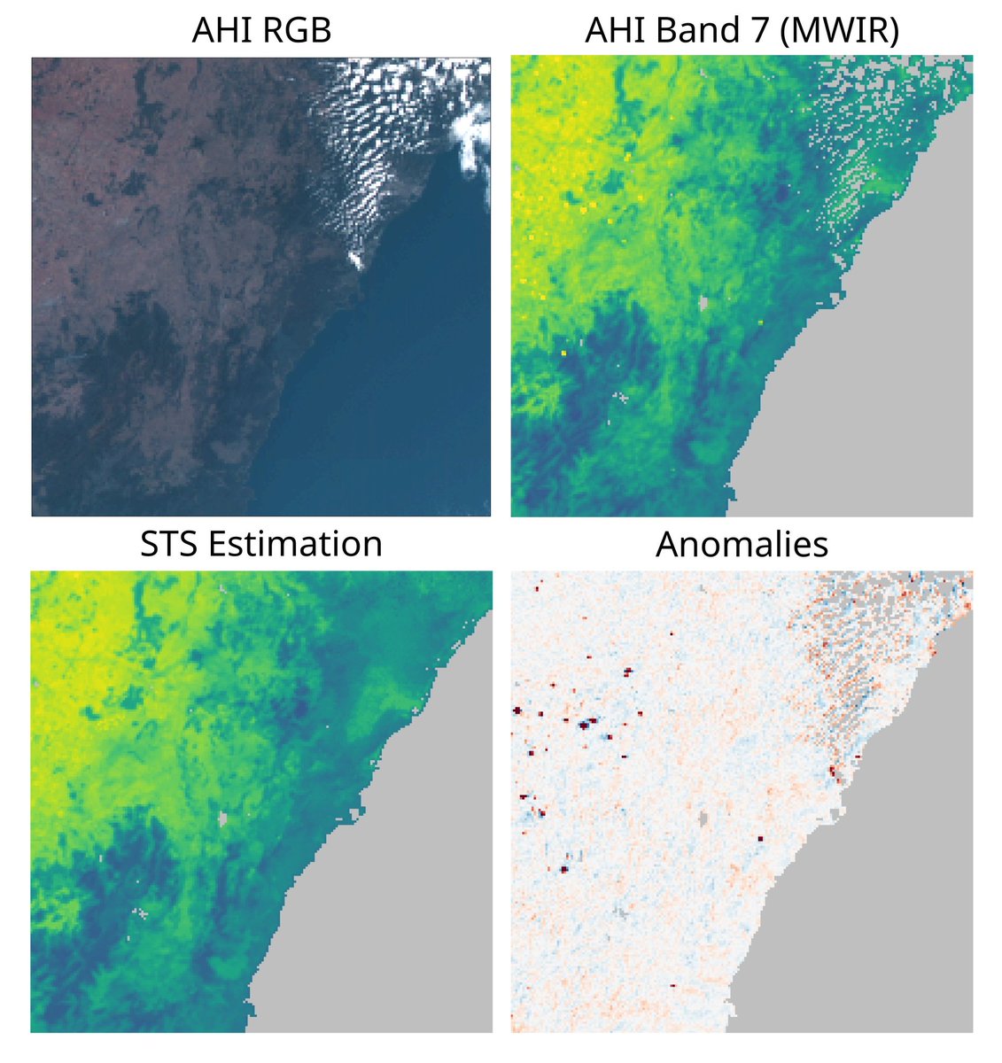
📢📄New paper: a novel method for the estimation of background temperature in perturbed geostationary MWIR imagery, using selections of like pixels that can be non-adjacent to the target pixel.
Read: https://t.co/HszZj4qtIc @janomecopter
#Forests 🌲✨ Editor's Choice Article - This study presents The Potential of Low-Cost #3D Imaging Technologies for #Forestry Applications: Setting a Research Agenda for Low-Cost #Remote Sensing #Inventory Tasks, by @JamesMcGlade et al.
More information: https://t.co/01zhX0aBPo
New paper: monitoring forest structure benefits ecology, fire, and carbon management. Bi-temporal #GEDI observations may improve accuracy. We have evaluated the compatibility of real and simulated GEDI for future combined use. @GEDI_Knights@SHuettermann https://t.co/YPTZo2jtHh
We are looking for participants to take part in a survey being conducted regarding perception of landuse and landcover (#LULC) in #Yungay#Chile
We would greatly appreciate your participation: https://t.co/lPF9j25Otv
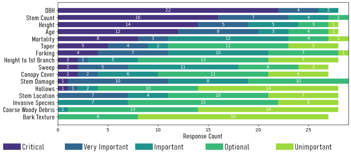
New paper: reviewing the application of terrestrial Low-Cost 3D sensors for forestry, and using survey responses from forest inventory professionals, we present a research agenda to assist in the operational adoption of RGB-D devices. Read: https://t.co/JzzOJKWQmu @JamesMcGlade
Millions of tons of plastic enter the oceans every year, ending up on remote beaches. Our recent article on using spectral signatures to detect these plastics has been recognised as the cover story for the Nov issue of #MDPI#RemoteSensing! https://t.co/DON4tWuiaN @Jenna_Guffogg
Visiting the Cocos Keeling Islands we studied plastic debris washed up by ocean currents. Spectral features from plastics can be used to detect contaminated areas and potentially be used for future remote sensing missions to detect plastics on coastlines.
https://t.co/fgSnKomoDK
Identification and preservation of koala habitat is crucial to their protection. Using field data, we examined the accuracy of 4 broad-scale low-resolution koala habitat maps in southeast QLD to see if they correctly depict food resources.
New paper here https://t.co/MUtXa9PF9G
The emergence of UAS and compact sensors (RGB and LiDAR) provide new opportunities to map fire severity. Collaborating with @TerraLuma we tested their utility to map severity in a sedgeland transition zone in Tasmania https://t.co/Xq5ysbjGKP #fire#severity#uas@SamCHillman1
Recently Professor Simon Jones spoke to @JamesPurtill about active fire detection from satellite imagery.
If you would like a definitive overview of the BRIGHT algorithm used for detection, it can be found here: https://t.co/UGY83s86jv
ABC article: https://t.co/awdil1rSlH
Through a case study in Chile, South America, we have explored how the perception of landscape is influenced by the growing accessibility of satellite imagery data.
New publication is here: https://t.co/EswRJ0eFbB
We are currently conducting a short anonymous survey that aims to capture the current requirements and challenges with the collection of forest inventory metrics and how low-cost sensors may help.
If you wish to participate the survey can be found here: https://t.co/AeAlp6eIHi
Image-based and LiDAR point clouds were captured using terrestrial and UAS platforms to compare below-canopy structural information. Using novel classification methods we concluded that below-canopy structure is present in TLS and UAS LiDAR point clouds.
https://t.co/D5zNCVi53m
Using the Microsoft Azure Kinect we captured individual stem DBH measurements of urban trees to determine the optimal #urbanforestry capture settings for this low-cost RGB-D technology. Check it out here: https://t.co/4qs7gO7hTA
@JamesMcGlade
Members of the RMIT remote sensing lab have been making the most of their time in stage-4 quarantine. Masters of Geospatial Science student Andy @Whity720 has taken to baking bagels alongside examining the structural and spectral qualities of vegetation from point clouds! #bagels
Working alongside @CSIRO we present a novel method for deploying Argo Floats so they rest on the seabed between profiles. Float depth and seabed bathymetry are used to estimate float location. We hope this method can be utilised to track floats below ice https://t.co/EXvEKnD8V2.