A geospatial non-profit committed to increasing awareness of #geospatial technology, industry best practices, and educational resources. #GIS#Geography#GEOINT
The 2026 conflict in Iran marks the rise of the "kill web"—where Geospatial AI compresses warfare from weeks to seconds. From autonomous swarms to the ethics of machine-speed violence, the cost of tactical precision is a devastating human toll. Read more: https://t.co/HbcoTY5ErN
#geoint #geoai #ai #geospatial
38 Days until @foss4gna 2025! Don't worry, we've got your back! As proud media partners, we're excited to offer the Project Geospatial community a 10% discount for the premier open source geospatial event of the year. Join us in Reston, VA, from November 3-5, 2025, to connect with industry leaders, dive into cutting-edge workshops, and explore the future of geospatial open source technology. We are especially looking forward to the B2B event hosted at the Barns at Wolf Trap. Come see Katie Picchione, Paul Ramsey, Bruce Momjian as this year's featured main stage guests!
Head over to https://t.co/KC9yvcELxi to secure your spot. When you register for the full conference, use our special discount code to save: 👉ProjectGeospatial_1103
This is your chance to be part of the conversation. See you in November!
#FOSS4GNA #FOSS4GNA2025 #Geospatial #OpenSource #GIS #FOSS #Mapping #GEOINT #OSGeo
The realities of AI/ML are reshaping & replacing traditional geospatial roles, forcing reevaluation of skills, careers, & the future of human expertise in understanding our world. The line of assistant & successor is becoming increasingly & alarmingly clear.
https://t.co/FSXp0Zs7Cp
Proposed FY26 cuts put U.S. #GEOINT leadership at risk! With foundational data from NOAA, NASA, USGS threatened, how will industry & agencies like NGA adapt? All eyes on #GEOINTSymposium for answers. Deep dive into the impacts:
https://t.co/O8Qg0XkeXC
#FY26Budget #Geospatial #techpolicy #geoint2025 #geoint #geospatial
FedGeoDay 2025, held April 22nd in Washington D.C., was a packed and energized convergence of over 200 geospatial experts dedicated to a vital mission: building resilience through open source tools and data. Project Geospatial's coverage of the event revealed a community deeply committed to collaboration, showcasing everything from NASA's critical Earth observation data applications and foundational government datasets like USGS's 3DAP to the complexities of AI reliability, the dynamics of open data initiatives like OpenStreetMap and Overture Maps, and the necessity of robust cybersecurity. The day underscored the immense potential of open geospatial solutions in facing increasing challenges and the collective effort required to harness their power for societal benefit. The palpable energy and high turnout signaled a community ready to tackle complex problems together, leveraging open platforms for a more resilient future.
Read more from our Article Highlighting Sessions from the event:
https://t.co/tVM8AHRAJZ
Watch all the sessions:
● PG's Coverage Page: https://t.co/dE6PKl2fN6
● Youtube FedGeoDay 2025: https://t.co/aQJAEIhgId
These sessions will be posted on major podcasting channels soon.
#GEOINT #OSGeo #OpenSource #Geospatial #FedCiv #FedGeo #FedGeoDay #FedGeoDay2025
The Emerging U.S. Geodesy Crisis
The United States is facing a looming crisis in its geodesy workforce, threatening the nation's capacity to maintain and advance this essential science. Our writeup delves into the definition, applications, and history of geodesy in the US, examining the workforce challenges and potential consequences if this crisis remains unaddressed.
Read the full and latest article in Geospatial Frontiers
https://t.co/FGUJEGEjou
#Geodesy #Geospatial #Maps #Geography #Geospatial #GeodesyCrisis
In the vast realm of satellite technology, few missions stand as tall as Landsat & Sentinel.
This infographic goes deep into the differences of these two, helping you navigate their roles in remote sensing & Earth observation.
#GIS#RemoteSensing#QGIS#Landsat#Sentinel#GEE
📢 Launching "Decoding Geo: AI Edition"! 🤖🌍
Dive deep into the world of geospatial tech with our AI-powered podcast series. We're using cutting-edge AI to analyze interviews, notes & data from events like #GEOINT, #FOSS4G, #Geography2050 & more!
🎧 ]Subscribe now: https://t.co/Y7Vp6aq5US #geospatial #AI #podcast
The open-source, cross-renderer Terra Draw library by @JamesLMilner has a demo site powered with @maplibre + @protomaps now!
Try it out at https://t.co/9xQqA01lh5
URGENT SPECIAL GEOSPATIAL ANNOUNCEMENT
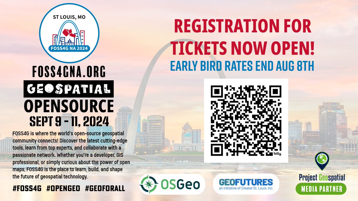
@foss4gna 2024 is coming up fast. There is still time to register and attend. It will be in St Louis, Mo Sept 9-11. Be sure not to miss this exciting event! We will see everyone there! Register now at https://t.co/KC9yvcELxi
#GEOINT #geospatial #maps #geoint #opengeo #OSGeo #GIS #opensource
Hey everyone! Registration is open for @foss4gna. It's the big annual "Free and Open Source Software For Geospatial" event. You can go to https://t.co/KC9yvcELxi directly to register.
Event Details: September 9-11, 2024
Location: St Louis, MO
FOSS4G NA is the premier conference for open-source geospatial technology and business in North America. It brings together a diverse community of developers, users, decision-makers, and enthusiasts to explore the latest advancements in open-source GIS tools, data, and practices.
The event features:
• Keynote presentations from industry leaders
• Technical talks and workshops on a wide range of topics
• Networking opportunities with potential partners and collaborators
An expo showcasing open-source geospatial products and services
FOSS4G NA is a unique opportunity to learn, connect, and contribute to the vibrant open-source geospatial community. It's the place to be for anyone interested in the future of GIS technology.
We are proud media partner of the event and are looking forward to seeing everyone there and supporting the endeavor!
#FOSS4GNA #FOSS4G #GEOINT #Geospatial #Geography #opensource #osgeo #geospatial
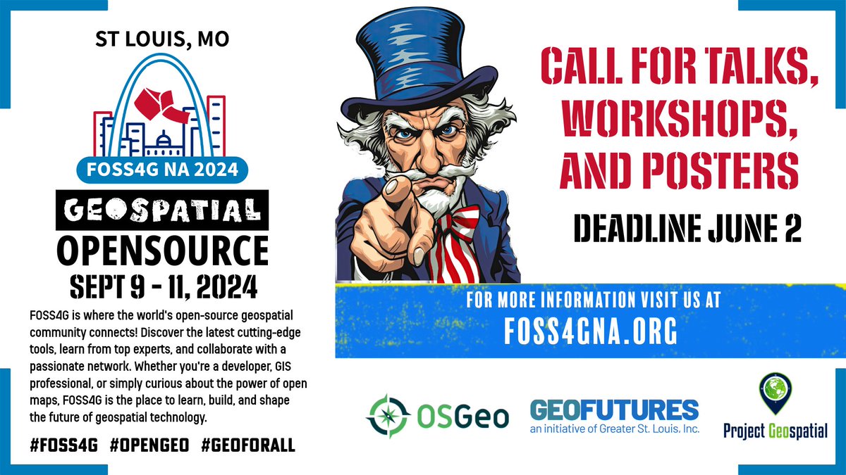
𝗪𝗲 𝗪𝗮𝗻𝘁 𝗬𝗼𝘂!
Call for Talks, Workshops, and Posters for @foss4gna in September! Submit by June 2nd!
🔹Submit through: https://t.co/bPr4zHhclH
🔹Questions? Please contact: [email protected]
🔹Find out more about FOSS4G NA: https://t.co/P0sdlJ9xyx
What is FOSS4GNA?? It stands for Free and Open Source Software for Geospatial North America. It's the leading conference focused on open-source technology in the geospatial field - that is, using software that's freely available and modifiable for tasks related to geographic information systems (GIS) and location data.
#OpenSource #OSGeo #Geospatial #GEOINT #Geo #FOSS4G
@FedGeoDay_US Content is up and AVAILABLE for everyone's post-event enjoyment, review, and sharing! At this time, you can find it on our Main Website and YouTube Channel. We are still working to get the content up into Podcasting streams and notify participants. Please standby on that front. Links Below:
* Project Geospatial FedGeoDay 2024 Page: https://t.co/Q2nSDrFrgr
* YouTube Channel: https://t.co/bPe09Q8WLo
#FedGeoDay2024 #FedGeoDay #GEOINT #Geospatial #OpenSource #FedCiv