[4/14] 6:03 PM- Strong to severe storms continue to develop and move across portions of OK and western north TX. Large hail, damaging winds, and heavy rain/flooding are currently the main concerns. #okwx#txwx
🥶It would be wise to bundle up tomorrow afternoon if you have to be outdoors, especially for a prolonged period.
Strong north winds + falling temperatures = BRRRR
By early evening, wind chill values will plunge into the 20's and 30's for many locations.
#okwx#texomawx
Tonight's softball game against Newcastle has been canceled due to rain and field conditions. 🌧️ This is a district game and we will let you know once a new date has been scheduled.
Morning update - We continue to anticipate severe weather across much of our area this afternoon and evening. Although very large (3+ inch) hail and tornadoes are possible, the biggest concern for us will be the potential for widespread 70+ mph wind gusts.
𝐎𝐒𝐒𝐀𝐀 𝐒𝐓𝐀𝐓𝐄 𝐂𝐇𝐀𝐌𝐏𝐈𝐎𝐍𝐒
As we wrap up another Championship Saturday, we want to say congratulations to all of the 2025 State Champions.
Well done, boys. 👏🏻
#OKPreps@SFWolvesBSB
Radar Update as of 10:25 PM - A cluster of storms is moving into central Oklahoma and will be approaching the OKC metro in the next hour or two. Stay weather aware and have multiple ways to receive warnings.
Currently only two storms, but golf ball size hail has been reported with these storms. Additional storms are developing to the southwest. #okwx#texomawx
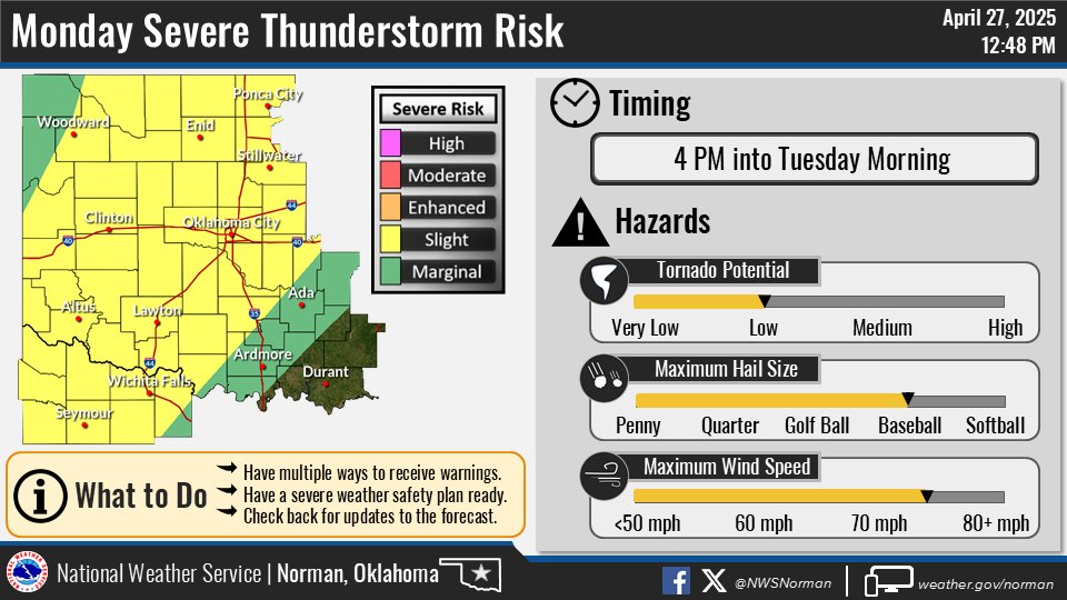
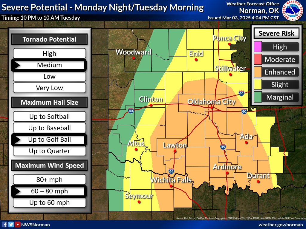
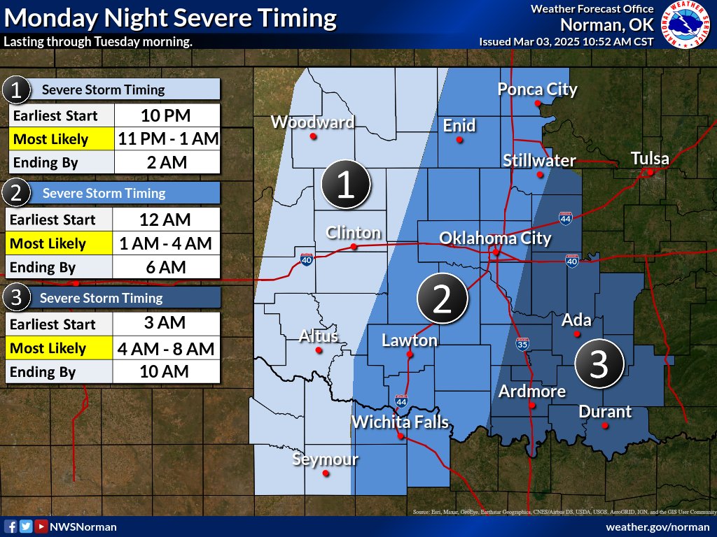
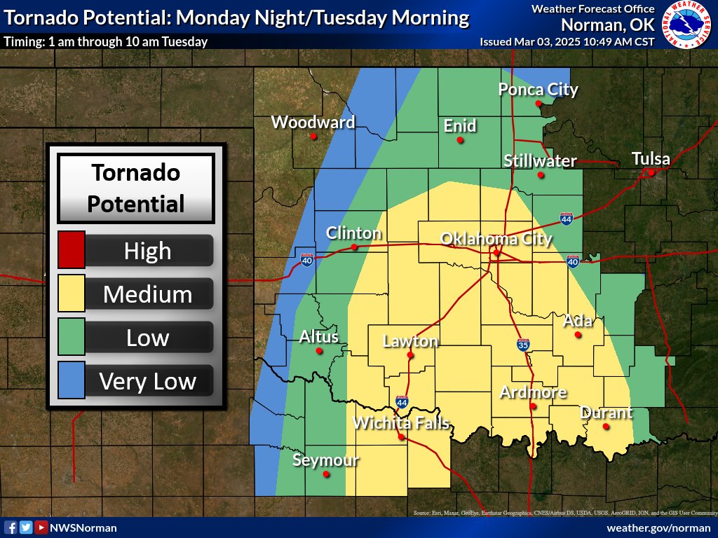
Another round of severe weather will be possible Monday afternoon into Tuesday morning. Very large hail and damaging winds are the primary hazards, but a tornado cannot be ruled out with any mature storm that forms. #okwx#txwx
Severe Weather Update...A cold front is advancing a little faster to the southeast than previously expected. Therefore, we have made an adjustment to the Slight Risk area, and altered the timing a little. #okwx#texomawx
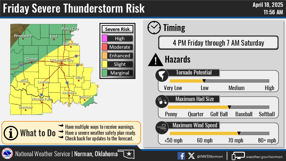
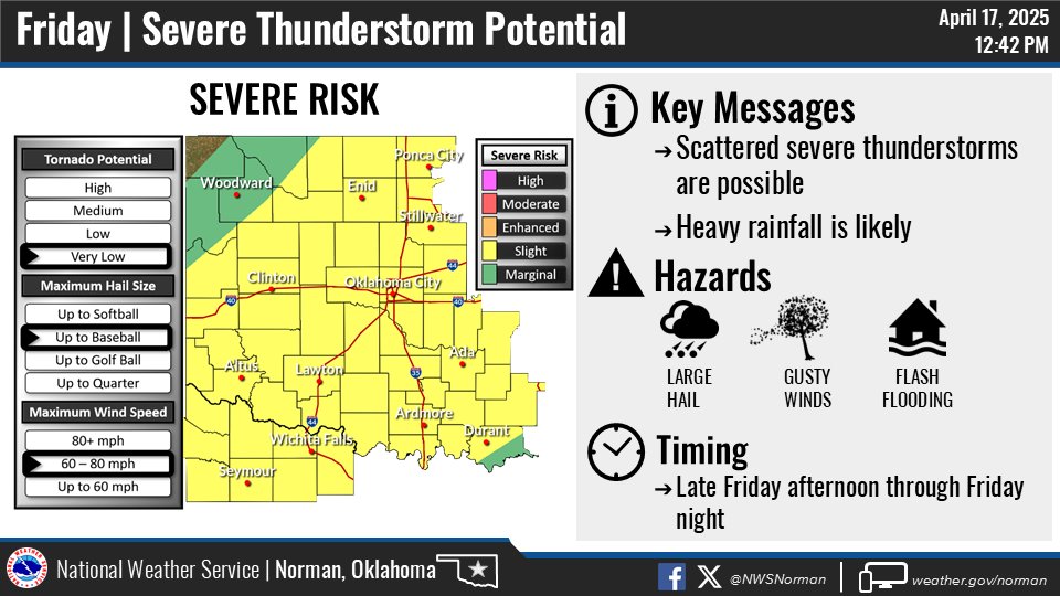
Here's the updated outlook for Friday severe storms. The main adjustment was to add the slight risk further to the northwest. The main hazards are still large hail and damaging winds. #okwx#txwx
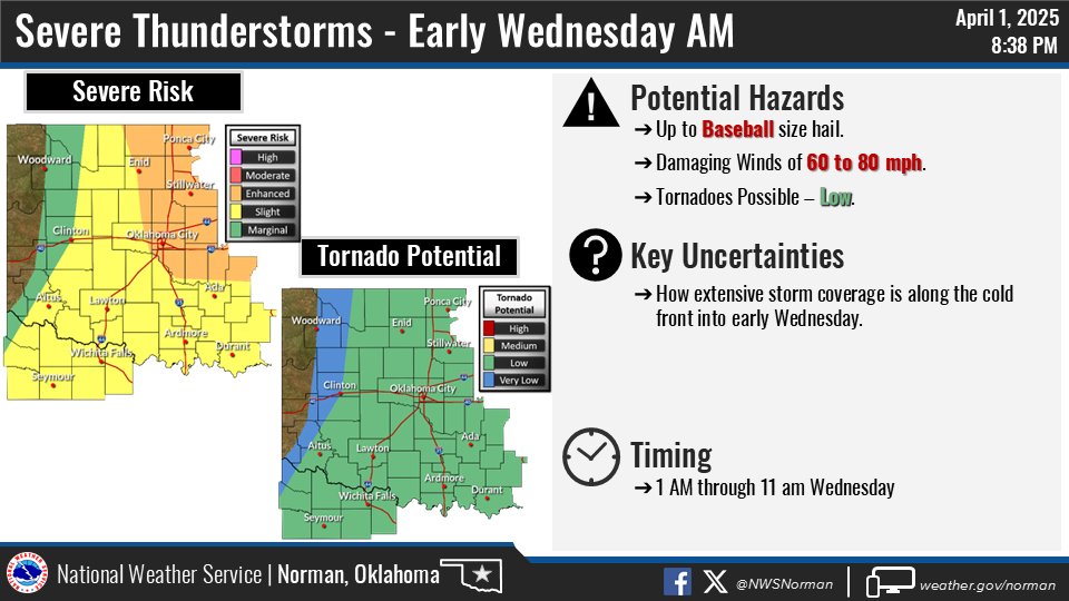
Even though the risk for severe thunderstorms has ended this evening, another round of severe weather remains possible early on Wednesday morning.
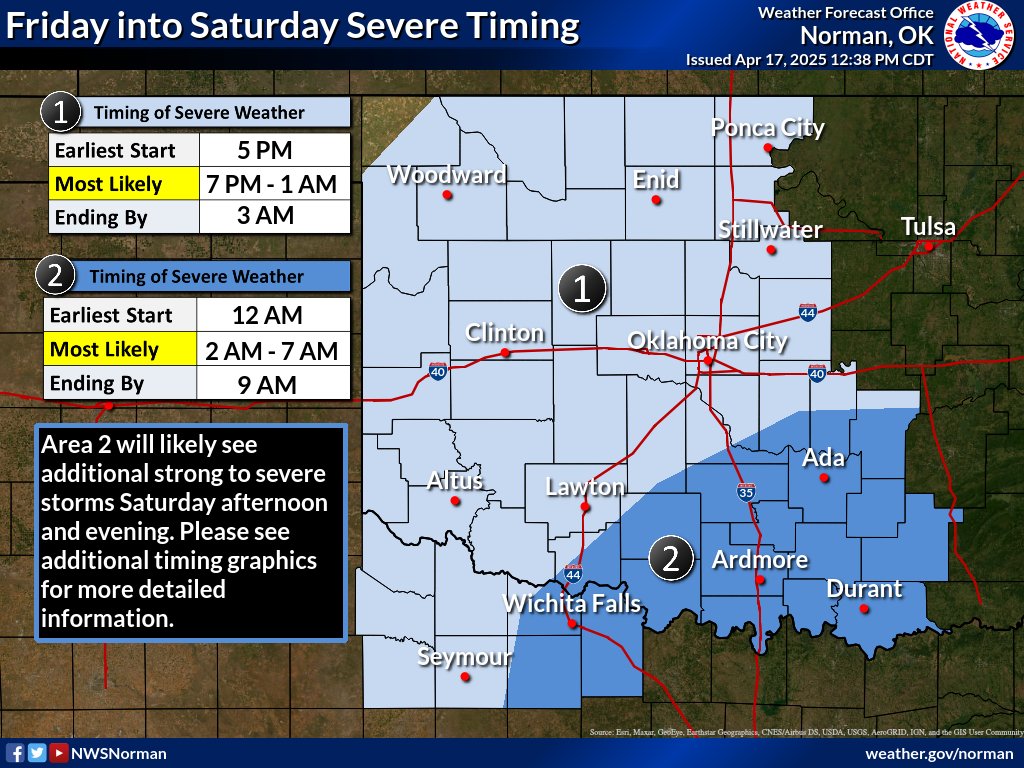
Here are the key messages for the overnight period. Remain aware and have a way to receive alerts as you sleep!
#okwx#texomawx
No major changes late this afternoon to the severe risk for tonight into Tues. Storms are currently expected to begin to develop around 10-11 pm in W OK then become a line moving across the area. Make sure you have a way to wake you up if a warning is issued. #okwx#texomawx
Severe weather update. Better instability is expected to develop late this evening and overnight, therefore, parts of the area are now in an Enhanced Risk of severe weather. The storm timing has not changed (mainly overnight/early Tuesday). #okwx#texomawx
Lady Dragons defeat Christo Rey in their home opener!! The Lady Dragon defense held Christo Rey to 1 goal while the offense put two balls in the net to win 2-1! Way to go Purcell Soccer!
6:30 PM - Winter precipitation, mostly snow, continues early this evening across parts of OK and western north TX. A few bands of heavier snow are affecting parts of central OK. Slick roadways also continue to be an issue so if you have to travel go slow. #okwx#texomawx