Ryan Shoptaugh, a native of San Antonio, will appear on KENS 5’s evening weekend newscasts as well as provide weather updates on KENS 5 digital channels. https://t.co/fZ0kRNZxb3
Rain this weekend won't be as intense as last Sunday, but still some good showers and a few downpours are looking more likely for a second Sunday in a row. Heaviest rainfall will likely be east of I-35. #txwx
Some rain totals across the region have exceeded 4" since Saturday afternoon! The average in San Antonio has been 1"-2" with localized pockets around 2"-3". Some good soaking rain!
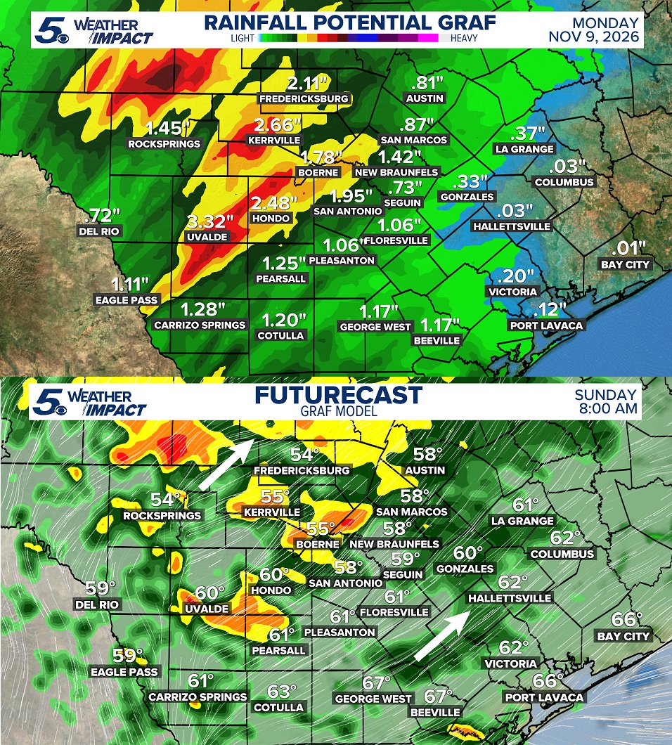
Rain picks up in coverage Sunday and Monday! Pockets of soaking downpours are looking to focus between Central and South Texas into the early part of the week. A solid 1"-3" is looking likely! #txwx
New ECMWF data shows the *strongest subtropical jet stream* in its forecast history blowing across the Pacific and U.S. this winter into next spring, with record-strength winds predicted from California to Florida.
There's even a connection to Europe.
El Niño fuels more thunderstorms near the equator, which release heat high into the atmosphere.
That extra warmth strengthens the Hadley circulation and steepens the temperature gradient between the tropics and the mid-latitudes, which strengthens the subtropical jet.
And that's why such a stormy winter is anticipated across the western, southern and eastern United States.
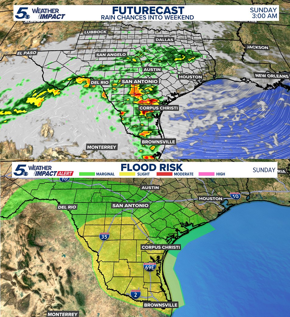
A slight risk for flooding this weekend. As rounds of rain move across South Texas Sunday, we may see some ponding and street flooding. Some areas may exceed 4" of accumulation. A cloudy, cold, and rainy weekend! #txwx
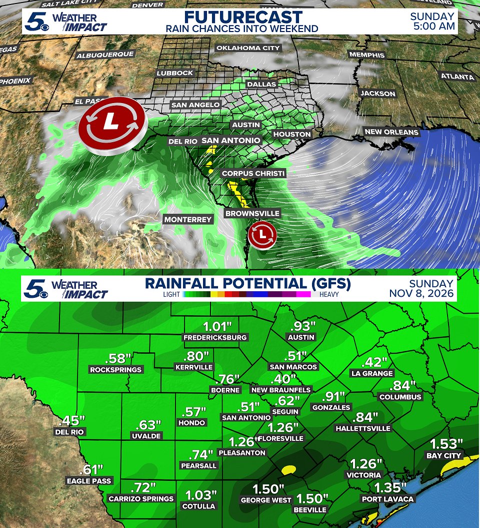
Increasing chances for showers and storms into Sunday as the next system approaches. The GFS is the model that is lowest on forecast rain totals, so this is a good signal. Add in cooler air this weekend, it'll be a chilly one. #txwx
@MatthewCappucci@KENS5 I apologize for that Matthew, didn’t mean to come off this way. I had someone share this content with me quickly, sorry for not doing due diligence, and for conveying in this regard. Again, I apologize.
COLD FRONT TUESDAY 👀 It won't be "strong" but it'll drop highs back down into the 70s for the rest of the week, bring some isolated storms Tuesday early and push out humidity this week. #txwx
Solid rain totals so far this afternoon! Highest accumulations have been across our western counties with some good downpours around San Antonio and I-35. Rain will gradually come to an end this evening. #txwx
8:10 AM - Rain will continue to stream in Thursday and Friday. Again, heaviest rain across western counties, but a few areas around the San Antonio metro may exceed 2" by Friday afternoon. Be safe! #txwx
ELECTION DAY COLD FRONT? A front will push through Texas on Tuesday, November 3rd! This will drop daytime highs back down into the 60s and 70s with lows in the 50s and 40s across the state. Similar to the last one. #txwx
While the heaviest rain will fall across West Texas and in our western counties this week, some pockets of rain may exceed 1" in areas around San Antonio. Hoping for some good rain Thursday and Friday! #txwx
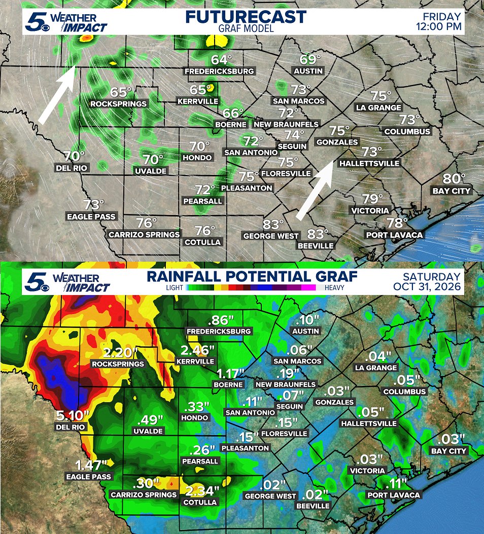
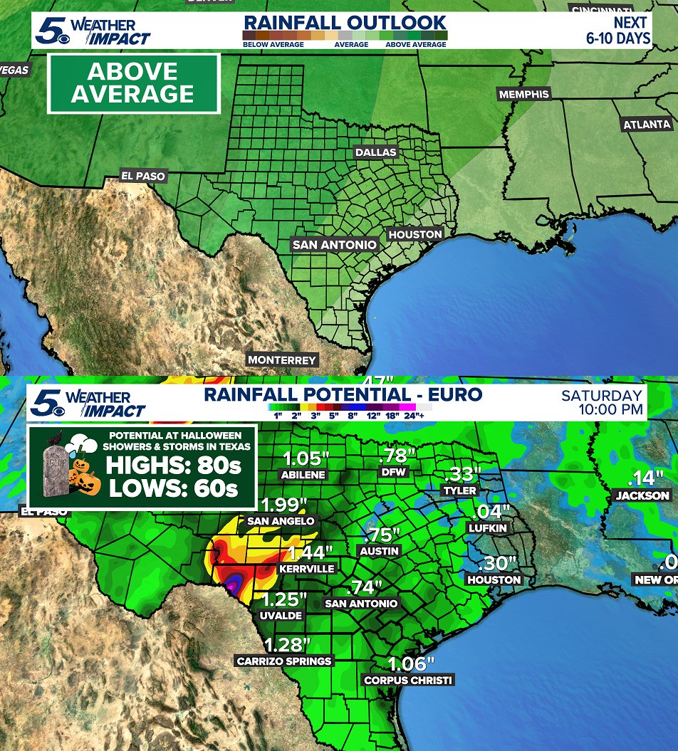
Good signal in the long range for some rain leading into Halloween. Likely the heaviest rain somewhere across West Texas with some showers and storms approaching the I-35 corridor, Friday and Halloween Day. #txwx
Our coldest morning in San Antonio since early spring! Morning temperatures dropped to 46 with colder air in the Hill Country. Our coldest morning in 214 days! #txwx
Its been a fairly normal October, rain-wise. Typical rainfall for San Antonio is around 3.75" and we're more than half way there! We may see a few chances for rain into next weekend. At the moment, only widely scattered into next Saturday. #txwx
It was our coolest morning since early spring! Morning lows dropped into the 50s and 40s area wide across the region and state. Colder across West Texas. Expect a little colder, Sunday morning. Calming winds and clear skies will help with that. #txwx
Grab a sweater or jacket this weekend! The mornings will start off CHILLY and end perfect with daytime temperatures int he 60s and 70s. If you don't have plans outside, MAKE THEM! #txwx
7:25 AM - Cold front pushing south closer to Corpus Christi this morning. Temperatures still stay cool in the 60s most of today and winds gusting near 40 MPH. The front is HERE. #txwx
COLD FRONT FRIDAY 👀 Winds will pick up in speed Friday morning gusting near 35 MPH. Overnight temperatures will drop into the 40s and 50s, Saturday morning. Get ready! #txwx