Welcome to the 5.10 Update!
This update adds the RRFS model and brings a major expansion to our Australian coverage: Australian Weather Alerts, plus a revitalized Australian radar network with new dual-pol products, additional tilts, and Bureau-standard site naming. 🧵👇🏻
Severe storms can strike after dark! With fewer visual cues and many people asleep, nighttime tornadoes can be especially dangerous. Keep emergency alerts enabled, have multiple ways to receive warnings, and know where you'll shelter.
TORNADO WATCH issued for portions of northern and central Arizona until 6 PM MST.
Storm coverage will increase this afternoon, with supercells capable of producing a few tornadoes, hail up to 2.5", and damaging wind gusts up to 70 mph.
Typhoon Champi has maintained an impressive satellite presentation over the past few days, with a well-defined eye and organized cloud bands as it tracked past Guam and across the Philippine Sea. 🌀 This GeoColor loop captures its persistent structure.
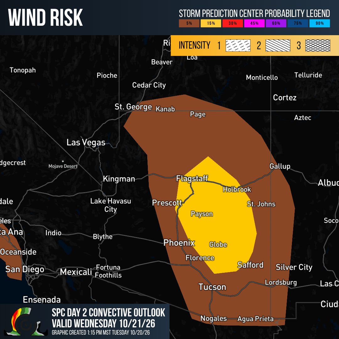
An ENHANCED risk (level 3/5) of severe weather covers parts of Arizona today and tonight! Multiple rounds of severe storms may bring 2"+ hail, damaging winds, and a few tornadoes. Tornado potential is greatest in northwest/north-central Arizona this afternoon and early evening.
A look at the nor'easter off the Mid-Atlantic coast today 🛰️ This system may develop some subtropical characteristics over the next couple of days as it moves over the Gulf Stream before moving away from the Eastern Seaboard later this week.
SPC has outlined an Enhanced Risk (Level 3/5) for portions of Arizona tomorrow, where an unusually significant severe weather threat is expected.
Large hail (potentially exceeding 2"), damaging winds, and tornadoes are all possible, with storms potentially continuing overnight.
Absolutely incredible 3D satellite presentation of Super Typhoon Champi from the Himawari-9 target sector as it continues churning in the Philippine Sea.
A powerful nor’easter will bring prolonged coastal impacts to the Mid-Atlantic through midweek! NHC is monitoring the system for possible subtropical development later this week. Regardless of development, coastal flooding, dangerous surf, and beach erosion are expected.
Severe weather doesn't take the fall off! ⛈️ Parts of the U.S. experience a secondary severe weather season during autumn. Make sure you have ways to get alerts and know your safe place if severe weather develops.
Watch Typhoon Champi’s weekend passage near Guam in this full PGUA reflectivity loop! Champi rapidly intensified before passing about 10 miles south of Merizo early Sunday morning, local time, as a Category 4-equivalent typhoon.
Super Typhoon Champi churns across the Philippine Sea with sustained winds near 160 mph, which is equivalent to Category 5 strength. 🌀 This quad pane satellite loop highlights its well-defined eye as Champi tracks northwestward!
Fall may be underway, but Atlantic hurricane season isn't over yet!
In October 2025, Hurricane Melissa intensified into a Category 5 hurricane before making landfall in Jamaica on October 28. GOES-19 imagery within RadarOmega captured the powerful late-season storm.
If you could watch one weather phenomenon unfold in person, what would it be? 🌪️
A supercell, a dramatic lightning display, a snowstorm, or something else?
Before the next tailgate, know where you'll go if the weather turns. 🏈⛈️ Identify a substantial building or hard-topped vehicle nearby, keep an eye on the forecast, and have a plan to get everyone to safety if storms approach.
Ever notice fog forming on cool fall mornings? When temperatures drop toward the dew point, moisture near the ground can condense into tiny water droplets, creating fog. Clear skies, light winds, and longer nights can make conditions favorable for fog development.
There's something about a crisp fall morning followed by a warm, sunny afternoon! 🍂
Clear skies and light winds favor overnight cooling, while sunshine warms the surface during the day. The takeaway? Clear, calm weather can bring big day-to-night temperature swings.
Did you know infrared satellite imagery works both day and night? 🛰️
GOES-19's Clean Longwave Infrared (Band 13) detects emitted radiation, allowing meteorologists to estimate cloud-top temperatures and monitor weather systems around the clock. View it all inside the app.