1897 Britton and Rey Map of Golden Gate Park, San Francisco Map showing the Golden Gate Park the Avenue and Buena Vista Park. Highlights the birds, deer, and bison living in Golden Gate Park. 10 x 54 inches This is an 1897 Joseph Britton and Jacques Josep https://t.co/cCx8g8KabF
1863 Collinson / Admiralty Nautical Chart / Map of Guangdong Coast, China China Sheet III. Eastern Coast from Chelang Pt. to Chauan Bay. Just after the Second Opium War. 19.5 x 26.25 inches This is a rare 1863 British Admiralty nautical map of Guangdong, https://t.co/3I7GzElVte
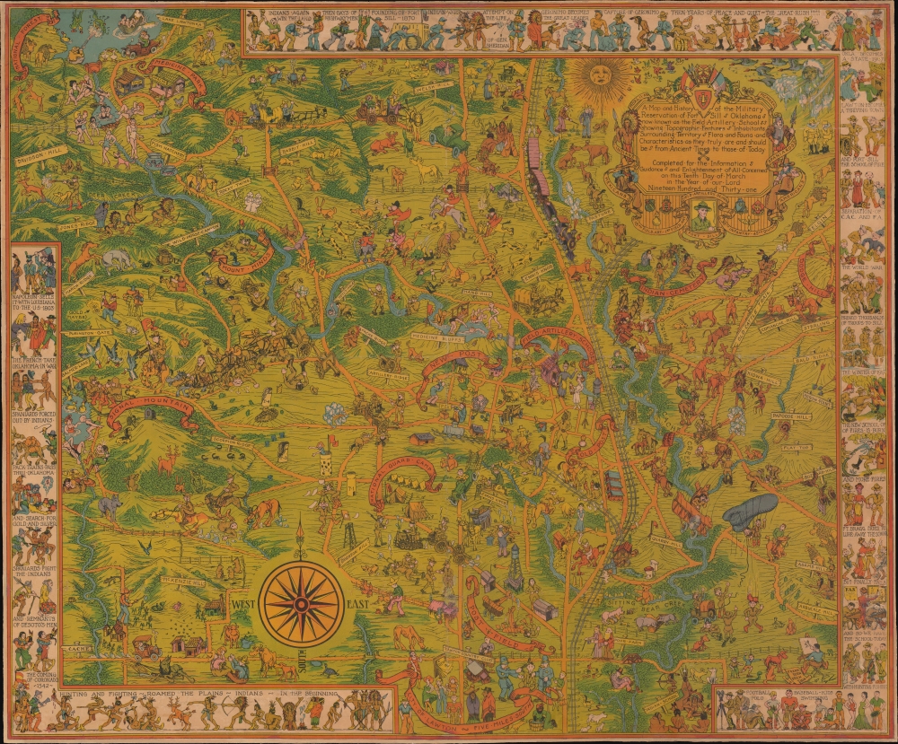
1931 Frank Dorn Pictorial Map of Fort Sill, Oklahoma A Map and History of the Military Reservation of Fort Sill Oklahoma now known as the Field Artillery School showing Topographic Features Inhabitants Surrounding Territory Flora and Fauna and Characteris https://t.co/eNmjthDEF1
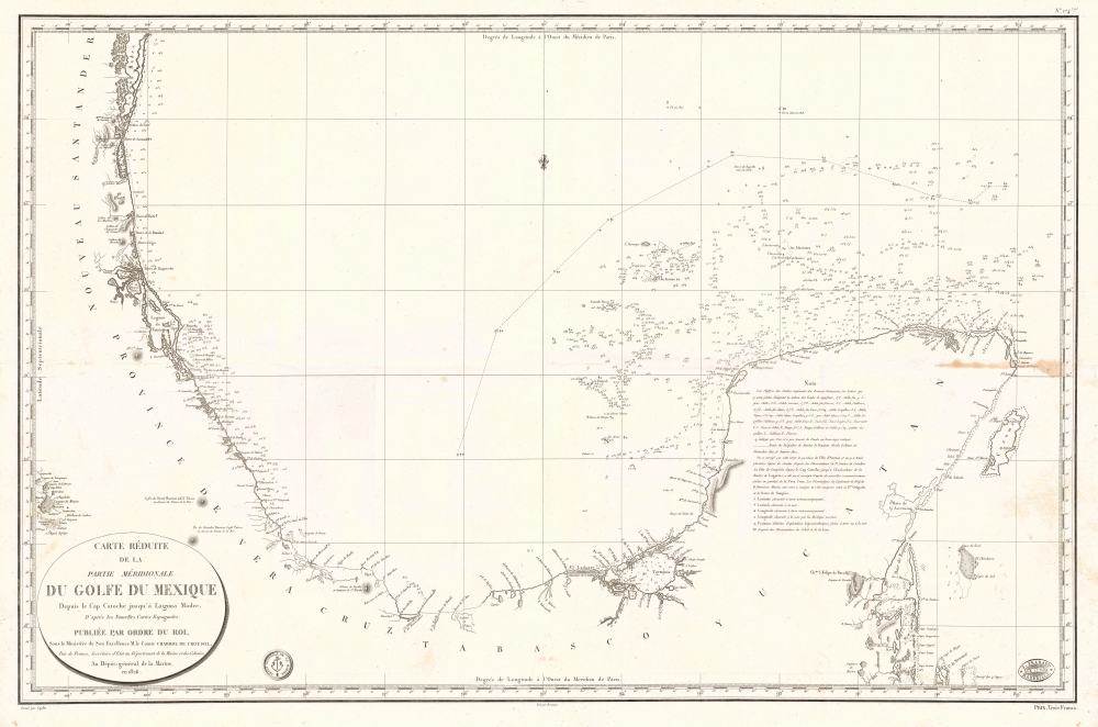
1826 Depot de la Marine Nautical Chart or Map of Bay of Campeche, Mexico Carte Réduite de la Partie Méridionale du Golfe du Mexique Depuis le Cap Catoche jusqu'à Laguna Madre. Increasing French interest in Mexico. 24 x 36 inches This is an 1826 Dépôt https://t.co/UyfLeCbdgq
1935 Visceglia City Plan of Rome, Italy Carta di Roma e suburbio. Mussolini's Mark on Rome. 34.25 x 24.75 inches A colorful, large-format 1935 Vincenzo Visceglia city map or plan of Rome, Italy - publication at the height of Italy's fascist era. Among oth https://t.co/GDYGK37jbO
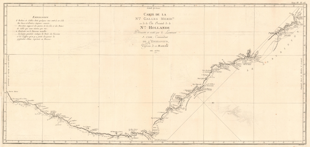
1774 Cook Map of New South Wales, Australia Carte de La Nle. Galles Meridle. Ou de la Cote Orientale de la Nle. Hollande Decouverte et visitee par le Lieutenant J. Cook, Commandant de L'Endeavour, vaisseau de sa Majeste en 1770. French Edition of the Firs https://t.co/5PyUaIAoFI
1962 AMS Map of the Moon Anticipating all 6 Apollo Landing Sites Mare Nectaris - Mare Imbrium. First Earthside lunar stereographic map - prepping for Apollo. 51.5 x 40.5 inches A seminal cartographic achievement, this is the first Earthside Stereographic https://t.co/GSGD4xYd9b
1647 Dudley Nautical Map of Hispaniola, Puerto Rico, and the Virgin Islands, West Indies Carta particolare dell'Isola Ispaniola è S. Gioni. nel'India ocidentle. con l'Isola Intorno. First usable printed nautical chart of Hispaniola and Puerto Rico. 20 x https://t.co/7TUnZyKts0
1957 Yeh City Plan of Taipei, Taiwan 臺北市圖 / [City Map of Taipei]. Taipei as the capital of 'Free China'. 30 x 20.25 inches A one-of-a-kind 1957 large-format folding map of Taipei by Yeh Hsien-k'ai. It depicts the city as it developed to accommodat https://t.co/uhmGugLYNy
1588 Livio and Giulio Sanuto Map of Morocco and Marrakesh Africae Tabula II. Best 16th century map of the region around Marrakesh. 15.5 x 21 inches This is Livio Sanuto's rare and beautiful 1588 map of central Morocco, focusing on Marrakesh and the area l https://t.co/Q1uwqOCHkj
1588 Livio and Giulio Sanuto Map of Egypt, Libya and the Lower Nile Africae Tabula VI. Geographical Reassessment of the eastern Sahara and the Lower Nile. 15.5 x 20.5 inches This elegant map of Egypt, focusing on the Lower Nile and Eastern Mediterranean c https://t.co/yp8c6eQYKG
1600 Matthias Quad Map of North America Novi Orbis Pars Borealis, America Scilicet, Complectens Floridam, Baccalaon, Canadam, Terram Corte . . . 1585. North America from the Great Age of Exploration. 9 x 12 inches A beautifully engraved, rare, and importa https://t.co/fe1XYSNHWq
1603 Ortelius Map of America Americae Sive Novi Orbis Nova Descriptio. First Printed Map to show the Chesapeake Bay. 14 x 19 inches This is Abraham Ortelius' map of the Western Hemisphere, in an attractive example of the 1587 third state. It represents th https://t.co/KXhMZN6HXI
1962 Philips / Vastenhoud Map of the World, for Short Wave Radio Enthusiasts Planisphère pour la réception des ondes courtes. Global Reach of Shortwave Radio. 31 x 43 inches This is a rare 1962 pictorial map of the world, published by the electronics https://t.co/K5S5mnjClX
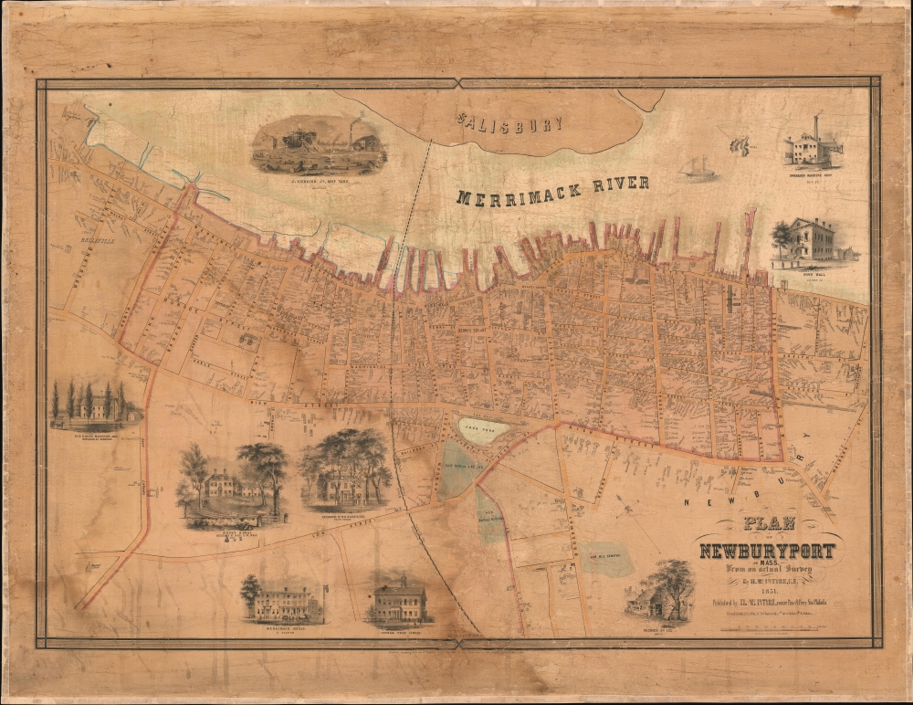
1851 McIntyre Wall Map of Newburyport, Massachusetts Plan of Newburyport, Mass. From an actual Survey by H. McIntyre C.E. 1851. Newburyport at its height as a Maritime Center. 25.75 x 38 inches A rare 1851 map of Newburyport, Massachusetts, produced by su https://t.co/qFaVzht01i
1980 Suren Yeremian Map of the Ancient Armenian Kingdom of Urartu ՈԻՐԱՐՏՈԻ ՊԵՏՈԻԹՅՈԻՆԸ [Kingdom of Urartu]. Armenian Kingdom of Urartu. 30.75 x 42.5 inches This is a rare separately issued Armenian-language 1980 Suren Yeremian map of th https://t.co/IxrTMDj2FN
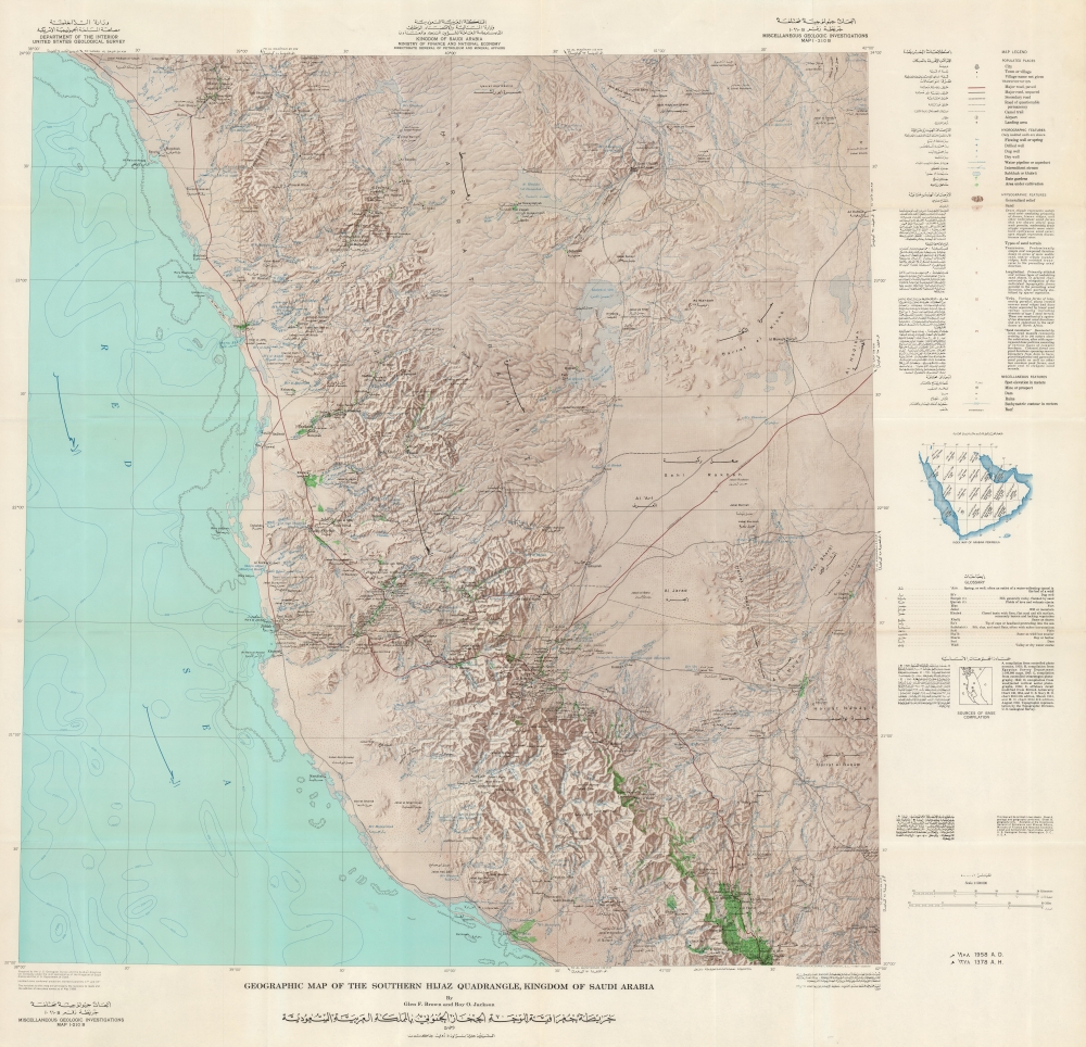
1968 Brown / Jackson Bilingual Map of the Southern Hijaz, incl. Mecca and Jeddah Geographic Map of the Southern Hijaz Quadrangle, Kingdom of Saudi Arabia Miscellaneous Geologic Investigations Map I-210B. / [خريطة جغرافية للوحة الحجا https://t.co/cYX9C0Mc1o
1940 Hagstrom Map of Midtown Manhattan Theaters, New York City Hagstrom's Map of New York Theatres, Hotels, Shopping District. Mapping New York Nightlife. 26.5 x 16.25 inches This is a c. 1940 Hagstrom map of Midtown Manhattan highlighting the city's icon https://t.co/x09an0uae2
1948 Menting KLM Royal Dutch Airlines Route Map of the World KLM Royal Dutch Airlines Winter 1948 - 49. KLM to the East Indies! 22.5 x 38.25 inches This is a highly decorative art deco large-format 1948 Jan Menting KLM Royal Dutch Airlines route map of th https://t.co/pZuqZgx0a6
1981 Forrest Pictorial View of the Hawaiian Islands The Islands of Hawaii / Islands of Hawaii Illustrated Pocket Map. Paradise of the Pacific. 16 x 22.5 inches This vibrant pictorial view of the Hawaiian Islands was drawn in 1981 by Kim Forrest for Travel https://t.co/03d0LvtaXL


![RareAntiqueMaps's tweet photo. 1957 Yeh City Plan of Taipei, Taiwan 臺北市圖 / [City Map of Taipei]. Taipei as the capital of 'Free China'. 30 x 20.25 inches A one-of-a-kind 1957 large-format folding map of Taipei by Yeh Hsien-k'ai. It depicts the city as it developed to accommodat https://t.co/uhmGugLYNy https://t.co/PHP0THEUf4](https://pbs.twimg.com/media/GgK71PMWkAAZRBq.jpg)


![RareAntiqueMaps's tweet photo. 1980 Suren Yeremian Map of the Ancient Armenian Kingdom of Urartu ՈԻՐԱՐՏՈԻ ՊԵՏՈԻԹՅՈԻՆԸ [Kingdom of Urartu]. Armenian Kingdom of Urartu. 30.75 x 42.5 inches This is a rare separately issued Armenian-language 1980 Suren Yeremian map of th https://t.co/IxrTMDj2FN https://t.co/gPpTw61evK](https://pbs.twimg.com/media/GgJbtS7WAAAruyn.jpg)