Every year, wildfires threaten lives, homes and nature.
The EU is deploying its largest-ever wildfire response:
🛩️ 22 firefighting planes, 5 helicopters
🧑🏽🚒 770+ firefighters pre-positioned in high-risk areas
🆘 24/7 emergency response centre https://t.co/6vsHRukf4x
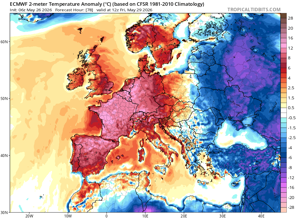
Potential Signals for Warmer & Drier Weather Mid-June 2026 ☀️
There are increasing signals that mid-June 2026 could turn warmer, drier and more settled across Ireland and parts of western Europe, although confidence remains moderate at this range.
Current ECMWF weekly anomaly guidance (15–22 June) shows a broad signal for above-average temperatures across Ireland and western Europe, with temperatures potentially running around +2°C to +6°C above average in places. A warmer-than-normal pattern is particularly evident across northern and western Europe. ECMWF sub-seasonal forecasts indicate a tendency toward higher pressure nearby and reduced rainfall signals, which can favour more settled conditions.
The pressure anomaly charts hint at higher pressure close to or west of Ireland, while recent GFS guidance also supports ridging/high pressure attempting to build toward Ireland and the UK, increasing the potential for more sunshine, lighter winds and drier spells. Rainfall anomaly charts suggest below-average precipitation signals across parts of western Europe, although rainfall forecasts at this range are naturally less reliable than temperature signals.
For Ireland, this could mean:
☀️ More settled weather at times
🌡️ Temperatures above seasonal average (+2°C to +6°C possible)
🌦️ Reduced rainfall potential compared with normal
🍃 Greater chance of high pressure influence
As always at this lead time, details will evolve, but the early signs are encouraging if you’re hoping for a more summer-like spell.
Follow for updates:
https://t.co/UMqk79yauS
Kenneth from the Donegal Weather Channel
☕You can also support my updates by buying me a coffee. By buying a coffee you are helping secure the future of the page which helps in the maintenance and running costs 👉 https://t.co/AtPIJrmFoZ
Forecast outlook based on ECMWF sub-seasonal and GFS model guidance — subject to change.
Watch @UN Secretary-General @antonioguterres' message about the emerging El Niño that is set to influence global temperature and rainfall patterns, increasing the risk of extreme weather in the coming months.
More information ➡️ https://t.co/htyps0XfsE
Rising global temperatures lead to drier conditions, increasing the likelihood of #wildfires. Simultaneously, warmer oceans provide more energy for hurricanes to form and strengthen.
https://t.co/im8fwaleIu
"disasters in 2025 included a Scottish “megafire” that torched more than 100,000 hectares.......and the Palisades and Eaton fires in Los Angeles, which were among the most destructive in US history
This isn't going away folks
https://t.co/HQHo2ZkT1v
A puny snowpack and widespread drought have experts predicting a severe U.S. wildfire season. They’re worried that the federal firefighting effort that’s in the midst of reorganization will struggle to cope. https://t.co/IaVawwwXi7
NEW DELHI — Indian Prime Minister Narendra Modi warned of the dangers of “extreme heat” gripping the world’s most populous country on Wednesday, with troops battling forest fires and local authorities reporting deaths from heatstroke. https://t.co/g8uMEeVvbI
🚨 6 people, including 5 minors, drowned amid extreme heat in UK
🌡️ Parts of London reached 35C on Tuesday, breaking record set a day earlier for hottest day in May https://t.co/5oXIEGcn3T
The record-smashing heat wave plaguing Western Europe is a “brutal” reminder of the cost of global warming, the United Nations’ climate chief has warned.
https://t.co/em6dlTbFRu
An El Niño will likely arrive later in the year, according to sea level data from Sentinel-6 Michael Freilich. The satellite—which measures the height of the entire ocean every 10 days—captured a swell of warm water hundreds of miles wide in the Pacific Ocean off the coast of South America.
A severe heatwave brought temperatures as high as 105.8 degrees Fahrenheit in Hanoi, Vietnam, straining the national power grid and leaving outdoor workers struggling https://t.co/74K4Hzn544
After London reached an unprecedented 35°C (95°F) today, southern France could make a serious run at 40°C (104°F) in the next few days.
We have never seen a heatwave this intense this early in the year across Western Europe. It's only late May.
Important add: Bilbao also tied its May highest temperature in history yesterday with 36.4C.
The heat in Central-Western Europe until the end of May will be hard to fathom:
Simply unprecedented in terms of areas,lenght and intensity.
🌡️ Unusually intense May heatwave in Europe
This weekend will bring very high temperatures to southwestern, western, and partly central Europe, locally up to 15 °C above the long-term average.
The reason is a persistent high-pressure system over Europe, drawing in hot air from North Africa along its western flank and acting as a so-called heat dome.
Air in the center of the high sinks and warms, suppressing cloud formation and allowing more solar radiation to reach the surface. As a result, hot air accumulates near the ground and continues to intensify.
Temperatures may exceed 30 °C in western and central Europe, and reach up to 38 °C in southwestern Spain.
Numerous daily temperature records are expected to be broken.
A large wildfire has burned nearly a third of Santa Rosa Island in California’s Channel Islands National Park — an area home to dozens of rare plants and animals, including some found nowhere else in the world. https://t.co/2dGemGUIjL
The United States is experiencing its driest start to a year in more than a century.
According to NOAA data and climate scientists, more than 60% of the country is currently under drought conditions, with over 20% facing extreme drought.
This is not a localized issue: the drought spans large portions of the Southeast, the Rocky Mountains, the Great Plains, and even parts of the Pacific Northwest that are typically wetter during La Niña patterns.
What makes this event especially unusual is its scale and timing. The period from January through March 2026 was the driest on record for the contiguous U.S. since comprehensive national records began in 1895.
While La Niña, a cooling of the equatorial Pacific, is playing a major role by suppressing rainfall across the southern states, this year’s pattern was compounded by unusually weak storm activity in the Northwest. As a result, both southern and western regions have become extremely dry simultaneously.
Compounding the problem is rising global temperatures. Warmer air increases evaporation and plant water loss (evapotranspiration), drying out soil, vegetation, and reservoirs much faster than in the past, even when rainfall deficits are comparable to previous droughts.
Parts of Colorado, Georgia, Florida, and the central Rockies are among the hardest-hit areas. In the West, the lack of mountain snowpack is particularly alarming, as it normally provides a critical natural water reserve for rivers, agriculture, and ecosystems through the dry summer months.
Scientists warn that these deep soil moisture deficits may persist even if summer rains arrive, because underground water reserves take much longer to replenish.
Forecasters are now monitoring the Pacific for signs of a potential strong El Niño later in 2026, which could bring much-needed relief and wetter conditions to the southern and western United States.
["Assessing the U.S. Temperature and Precipitation Analysis in March 2026." NOAA]
EUROPEAN HEAT WAVE
Hot air from MOROCCO (Today 44.1C) reached Iberian Peninsula and France.
Today 37.7C at Badajoz, SPAIN and
35.0C at Soort Hossegor, FRANCE
This is nothing to what's coming:
38/40C in Spain and 35/38C in France for 8 consecutive days.
Records will be thousands.


![Rainmaker1973's tweet photo. The United States is experiencing its driest start to a year in more than a century.
According to NOAA data and climate scientists, more than 60% of the country is currently under drought conditions, with over 20% facing extreme drought.
This is not a localized issue: the drought spans large portions of the Southeast, the Rocky Mountains, the Great Plains, and even parts of the Pacific Northwest that are typically wetter during La Niña patterns.
What makes this event especially unusual is its scale and timing. The period from January through March 2026 was the driest on record for the contiguous U.S. since comprehensive national records began in 1895.
While La Niña, a cooling of the equatorial Pacific, is playing a major role by suppressing rainfall across the southern states, this year’s pattern was compounded by unusually weak storm activity in the Northwest. As a result, both southern and western regions have become extremely dry simultaneously.
Compounding the problem is rising global temperatures. Warmer air increases evaporation and plant water loss (evapotranspiration), drying out soil, vegetation, and reservoirs much faster than in the past, even when rainfall deficits are comparable to previous droughts.
Parts of Colorado, Georgia, Florida, and the central Rockies are among the hardest-hit areas. In the West, the lack of mountain snowpack is particularly alarming, as it normally provides a critical natural water reserve for rivers, agriculture, and ecosystems through the dry summer months.
Scientists warn that these deep soil moisture deficits may persist even if summer rains arrive, because underground water reserves take much longer to replenish.
Forecasters are now monitoring the Pacific for signs of a potential strong El Niño later in 2026, which could bring much-needed relief and wetter conditions to the southern and western United States.
["Assessing the U.S. Temperature and Precipitation Analysis in March 2026." NOAA]](https://pbs.twimg.com/media/HI1Xbj2XYAAG4mJ.jpg)


