🌀 Typhoon Champi approaches Taiwan
Typhoon Champi is bringing very strong winds, torrential rain and high waves to Taiwan and nearby Japanese islands.
Across Japan's Sakishima Islands, wind gusts exceed 100 km/h (28 m/s), with 113 km/h (31 m/s) recorded on Yonaguni Island. Miyakojima has received approximately 200 mm of rain in the past 24 hours.
Champi is about 400 km from Taipei. Maximum sustained winds reach 180 km/h (50 m/s), with gusts up to 215 km/h (60 m/s). The typhoon is moving northwestwards at 18 km/h (5 m/s).
Champi will approach northeastern Taiwan on Friday before turning northeastwards towards southern Japan over the weekend. It could affect Kyushu early next week, with sustained winds expected to weaken to 55–65 km/h (15–18 m/s). Champi will gradually weaken and eventually transition into an extratropical cyclone.
Main hazards for the northeastern half of Taiwan and nearby islands:
Very strong winds: Gusts may exceed 100 km/h (28 m/s).
Extreme rainfall: Northern and northeastern Taiwan could receive 100–400 mm, locally up to 500 mm, and over 600 mm in mountainous areas. Taipei could see more than 300 mm. Flooding and landslides are possible.
High waves: Waves may reach 8 m, occasionally up to 10 m.
⚠️ Stay updated with the latest official weather warnings.
💨 Storms Austen and Boelo to bring severe weather to northwestern Europe
Two powerful Atlantic storms, Austen and Boelo, will bring very strong winds, heavy rainfall and rough seas to northwestern Europe from Thursday evening through the weekend.
🌀 Storm Austen is undergoing explosive cyclogenesis as it approaches Ireland and the UK. A strong jet stream over the Atlantic is contributing to its rapid deepening.
Overnight into Friday, Austen will mainly affect southern and eastern Ireland before moving along the English Channel, with severe weather expected across southern England and northern and northwestern France.
Wind gusts may reach 110–130 km/h (70–80 mph) in exposed areas. Falling trees, power outages and transport disruption are possible. Large waves are also expected along the coasts of Ireland, Brittany, Wales and southern England.
The storm will also bring heavy rainfall, with totals of 20–40 mm, locally reaching 60–80 mm. This could lead to localised flooding.
By Friday afternoon, the storm will move over the southern North Sea, extending its impacts to the Benelux countries and northwestern Germany.
🌀 Storm Boelo is currently developing over the Atlantic and is expected to deepen significantly on Friday and Saturday. From Saturday into Sunday, it will bring another round of heavy rainfall and very strong winds, mainly affecting Northern Ireland, Scotland and northern England.
⚠️ Damaging winds, dangerous coastal conditions and localised flooding are expected. Stay up to date with the latest weather warnings.
🌀 Super Typhoon Champi heads towards Taiwan
Champi is already the fifth super typhoon of 2026 in the western North Pacific.
At 12:00 UTC, its centre was located approximately 580 km north of Yap. Maximum sustained winds were around 260 km/h (72 m/s), with gusts reaching 315 km/h (87 m/s). The typhoon is moving northwest at around 25 km/h (7 m/s).
Over the next few days, Champi is expected to continue generally northwestwards while gradually weakening. However, from Thursday, uncertainty over its future track increases significantly.
Some model scenarios suggest Champi could cross Taiwan on Saturday and continue towards China's east coast. Others indicate a more pronounced turn towards the north or northeast, which could bring the typhoon close to the Ryukyu Islands from Friday into the weekend, and later towards the Japanese islands of Kyushu and Honshu.
⚠️ Please follow the latest weather forecasts.
🌧️⛈️ Heavy rain and flooding in the western and central Mediterranean
Heavy rain has affected Spain's Valencia region since the weekend. The rainfall is associated with Adam, the first named system of the 2026/2027 season. Adam is an isolated upper-level low, an area of cold air aloft that has become cut off from the main atmospheric flow. It increases atmospheric instability and supports the development of severe thunderstorms and very intense rainfall.
More than 300 mm of rain has fallen locally in the Valencia region in 24 hours, with totals since Saturday exceeding 500 mm in some areas.
The area of intense thunderstorms and heavy rainfall is now shifting towards the Balearic Islands and southern France. Very high rainfall totals are expected in southeastern France. In the Cévennes, 300 to 350 mm could fall locally, about a month and a half of typical rainfall.
On Tuesday, heavy rain and thunderstorms will also spread into northern Italy, particularly Liguria, before moving farther towards the Balkans.
⚠️ In the affected areas, intense rainfall could trigger flash flooding and significant rises in river levels.
🌀 Hurricane Trudy rapidly strengthens into a major hurricane
Hurricane Trudy has rapidly intensified overnight into a Category 3 hurricane, with maximum sustained winds reaching 195 km/h (120 mph). It is expected to strengthen further.
Trudy is moving slowly northwestward and is forecast to approach Mexico's southwestern and west-central coasts this weekend, potentially remaining a major hurricane.
Most forecast models keep Trudy's centre offshore. However, even small track changes could significantly affect the severity of impacts along the Mexican coast.
Main threats include damaging winds, storm surge, torrential rainfall and dangerous waves. Heavy rainfall could trigger life-threatening flash floods and landslides, particularly in Michoacán, Colima and Jalisco, Mexico.
⚠️ Follow official warnings and forecast updates.
Three tropical cyclones will hit North America this weekend
🌀 Hurricane Isaias
It is strengthening over the Gulf of Mexico and is currently a Category 2 hurricane, likely to briefly reach Category 3. Its centre is expected to make landfall around 8:00 PM local time near the Alabama–Florida Panhandle border, close to Pensacola.
Parts of the Gulf Coast face a life-threatening storm surge and damaging hurricane-force winds. Heavy rain will also bring a risk of flash, urban and river flooding across the southeastern United States.
🌀 Hurricane Simon
It is expected to reach Mexico's southwestern coast on Saturday evening and strengthen into a Category 4 hurricane today over the warm eastern Pacific. As it nears the coast, it is already bringing strong winds and intense rainfall, particularly around Lázaro Cárdenas. Severe weather will spread north towards Manzanillo, Puerto Vallarta and Tepic.
Life-threatening winds, storm surge, heavy rain, flooding and landslides are possible. Dangerous surf and rip currents will affect the coast through the weekend.
🌀 Tropical Storm Rachel
It is expected to move inland over northern Baja California early Sunday and continue into the southwestern United States later that day. It will bring strong wind gusts and heavy rain, with a risk of flash and urban flooding. Dangerous surf and rip currents are also expected along Southern California and northern Baja California.
🌀 Isaias becomes the first hurricane of this year’s Atlantic season
Hurricane Isaias strengthened from a tropical storm into a hurricane at 03:30 UTC on 8 October 2026. It became the first Atlantic hurricane of the 2026 season and the latest first hurricane since the beginning of the satellite era. It also tied the 1905 mark for the latest first hurricane in the historical Atlantic record.
Typically, the first Atlantic hurricane forms around 11 August, according to NOAA/NHC’s 1991–2020 climatology.
Isaias is located north of the Yucatán Peninsula and is moving northeastward. It is expected to gradually turn northward, with its centre forecast to make landfall somewhere between eastern Louisiana and western Florida overnight into Saturday. The system will then continue farther across the southeastern United States over the weekend and gradually weaken.
Main threats to the coasts of Louisiana, Alabama and western Florida:
Wind: Winds will begin strengthening in coastal areas today. At landfall, maximum sustained winds may exceed 100 mph (160 km/h), with even stronger gusts.
Rain: Intense rainfall is expected, with local totals of up to 10 in (250 mm). Flash flooding and urban flooding are possible, along with isolated river flooding.
Storm surge and high waves: The combination of storm surge, high waves and high tide may flood low-lying coastal areas. Life-threatening surf and strong rip currents are also possible.
⚠️ Please follow official warnings.
🌀 Hurricane Nolo becomes Typhoon Nolo / Typhoon No. 28
On Sunday, 4 October at 21:00 UTC, Hurricane Nolo crossed the International Date Line and entered the western Pacific, where it was reclassified as a typhoon.
The system may now be referred to as Typhoon Nolo, while its original identifier, 15E, may still appear in some contexts. RSMC Tokyo/JMA lists it as Typhoon No. 28.
Responsibility for the system also shifted from the Central Pacific Hurricane Centre to RSMC Tokyo/JMA.
This is the first hurricane-to-typhoon transition since Dora in August 2023.
Nolo first formed in the eastern Pacific on 13 September as Tropical Depression Fifteen-E. In mid-September, it temporarily weakened below tropical cyclone status, but later re-formed and strengthened into a hurricane. It then passed south of Hawaii as it continued westward across the central Pacific. After more than three weeks travelling across the Pacific, it reached the International Date Line. So far, it has travelled more than 7,000 km (4,300 mi).
Nolo is continuing generally westward and is expected to maintain a similar intensity in the short term. Gradual weakening should follow later.
On Thursday, 8 October, it is forecast to pass north to northeast of the Japanese island of Minamitorishima. It should then gradually turn northwestward and continue into waters south to southeast of Japan.
🌀 Rachel becomes a major hurricane
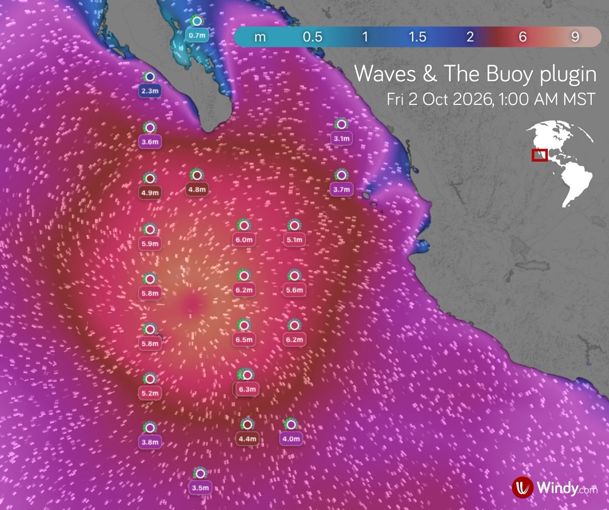
Hurricane Rachel has strengthened into a Category 3 major hurricane, becoming the eighth major hurricane of the season in the central and eastern North Pacific.
Its outer rainbands are bringing heavy showers and thunderstorms to southern Baja California. Large waves are affecting the southern part of the peninsula and Mexico's west coast.
At 1:00 AM MST on Friday, 2 October 2026, Rachel’s centre was located about 420 km (260 miles) south of Cabo San Lucas, near the southern tip of Baja California. Maximum sustained winds are around 190 km/h (120 mph), with gusts up to 240 km/h (150 mph). The hurricane is moving very slowly westward at around 4 km/h (2 mph).
Rachel is expected to strengthen into a Category 4 hurricane within the next few hours and pass very close to the uninhabited San Benedicto Island, north of Socorro Island.
Rachel will then continue moving westward and is expected to gradually weaken.
⚠️ Large waves generated by Rachel will continue to cause dangerous surf and rip currents along the west-central coast of Mexico and the Baja California Peninsula.
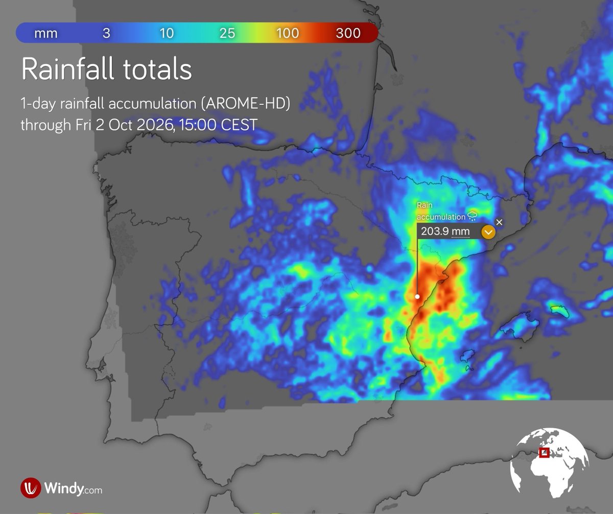
⛈️ Severe thunderstorms will affect eastern Spain, with extremely high rainfall totals possible
Thunderstorms are beginning to develop across eastern Spain and the Balearic Islands. Their development is linked to strengthening easterly winds, which are bringing large amounts of moisture from the Mediterranean Sea into the lower atmosphere. As a result, the storms may produce exceptionally intense rainfall.
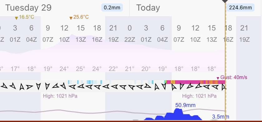
The Spanish meteorological service AEMET has issued warnings for extreme rainfall from this afternoon into Friday morning, roughly for coastal areas between Reus and Valencia.
Intense and repeated thunderstorms and showers may produce more than 90 mm in one hour and 200–300 mm in less than 12 hours. Flash flooding is possible.
On Friday, severe thunderstorms may also affect southeastern Spain.
⚠️ Please follow official weather warnings and forecasts.
🌧️⛈️ Heavy rainfall and a risk of flash flooding across the Southern and Central Plains, USA
A frontal boundary is moving across the central United States, with thunderstorms developing along and ahead of the front.
Their development is supported by abundant moisture from the Gulf of Mexico, combined with unusually high tropical moisture associated with the remnants of Hurricane Polo. The front will move slowly, allowing thunderstorms to repeatedly affect the same areas.
Today, Thursday, the heaviest rainfall is expected mainly across Texas and the Southern Plains. The highest totals and most significant impacts are forecast in the Texas Hill Country. According to the NOAA/NWS Weather Prediction Centre (WPC), hourly rainfall rates are likely to reach 1–2 inches per hour (25–50 mm/h), with short-term rates potentially as high as 3–4 inches per hour (75–100 mm/h). Repeated thunderstorms could bring more than 6 inches (150 mm) of rain in 24 hours.
Numerous flash floods, rapid rises on small streams and mudflows in some areas are possible.
Heavy rainfall is also expected farther northeast, particularly across Iowa, Illinois, Wisconsin and the Mid-Mississippi Valley.
On Friday, the main risk will shift towards southern, central and eastern Texas, where another 50–100 mm of rain may fall. Heavy rainfall will also spread along the Gulf Coast and farther towards the Ohio Valley.
⚠️ The main hazards remain flash flooding, flooded roads and mudflows in some areas.
🌧️⛈️ A major Mediterranean rainfall event is affecting southern France, the first of the season
Very heavy rain accompanied by thunderstorms has been affecting southern France, especially the Languedoc region, since Tuesday. Rainfall intensity may increase further today. On Thursday afternoon, the most intense storm-related rainfall is expected to gradually shift eastwards.
According to Météo-France, hourly rainfall totals in the Cévennes may reach 50–80 mm, while total rainfall over the event may reach around 200 mm, locally 250–350 mm.
⚠️ Such intense and persistent rainfall can trigger flash floods, river flooding, landslides and mudflows.
What is a Mediterranean rainfall event?
It is a period of very intense rainfall that most often affects the French Mediterranean regions in autumn. Warm, moist air from the Mediterranean Sea moves inland and, as it is forced to rise over mountainous terrain, favours the development of strong and repeated thunderstorms. Over several hours to several days, rainfall totals can therefore far exceed typical monthly amounts.
These events occur on average three to six times a year, mainly between September and December.
🌧️⛈️ Severe weather will affect the eastern Mediterranean and the Aegean Sea
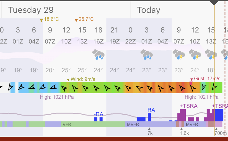
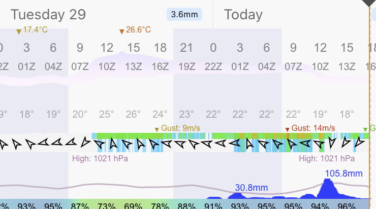
A period of very unsettled weather is developing across parts of the eastern Mediterranean, bringing heavy rain, thunderstorms and strong winds.
The greatest risk of very heavy rainfall is currently centred on Crete, where the Hellenic National Meteorological Service (HNMS) warns of locally very heavy rain and thunderstorms, especially in northwestern Crete. These conditions may continue intermittently into the weekend.
The heavy rainfall is linked to a low-pressure system over the eastern Mediterranean, which is drawing moist air towards Crete. Combined with atmospheric instability and the island’s mountainous terrain, this can significantly enhance rainfall totals.
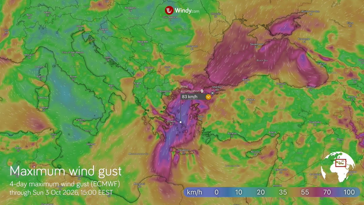
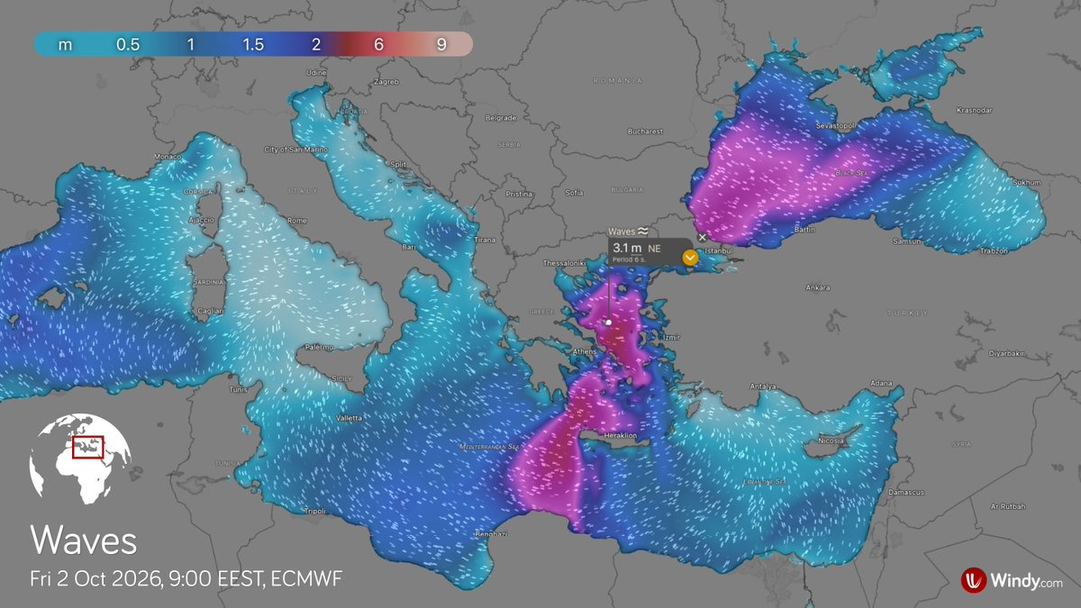
Very strong northeasterly winds will affect much of the Aegean Sea, locally reaching gale force and creating very rough sea conditions.
⚠️ The main hazards are intense thunderstorms, strong winds, flash flooding and dangerous conditions at sea.