A pretty classic South Florida radar loop.
You can see sea breeze and storm generated boundaries interacting across the region, with new thunderstorms developing where they merge.
Always cool to watch these small scale features show up so clearly on radar. #flwx
@SCweather_wx Mmm that northerly flow moving in bringing all that dry air, we like to see that, we’ll see how much it lowers the temps, hopefully by a noticeable amount for the Carolinas.
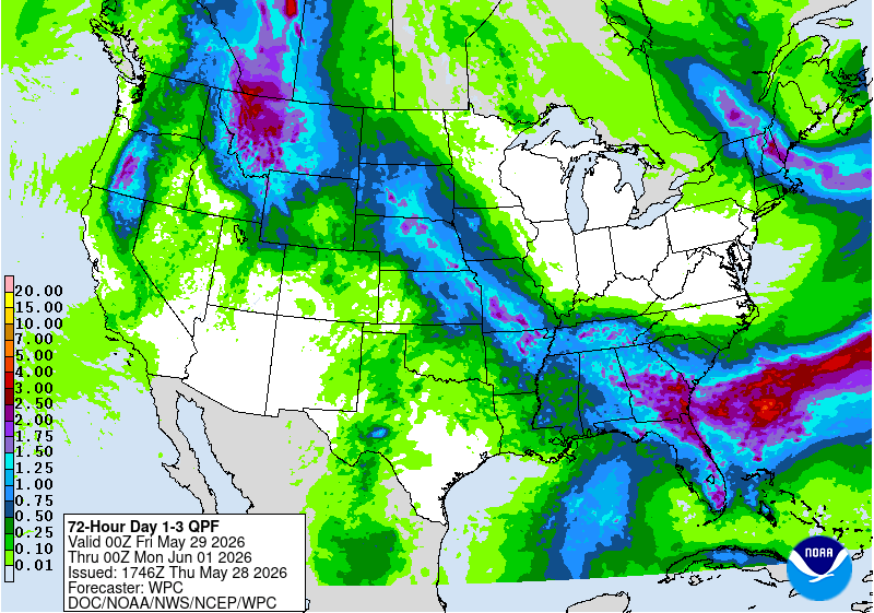
Guidance continues to show a wetter/unsettled pattern across Florida and parts of the Southeast heading into early June, although some of the more aggressive rainfall signals from previous ensemble runs have trended downward over the last couple of cycles.
Even so, a prolonged fetch of tropical moisture and above-normal PWAT values should support daily rounds of showers and thunderstorms with locally heavy rainfall possible at times.
Right now, this appears more like a typical early wet-season tropical setup rather than a widespread high-end flooding event, but some areas could still pick up locally higher totals where storms repeatedly develop. #flwx #sewx
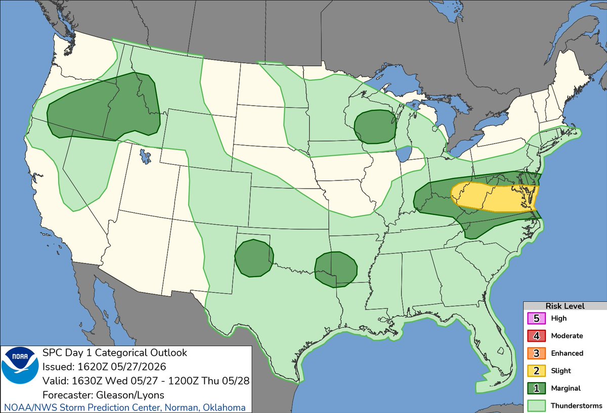
Slight risk in place across parts of the Mid-Atlantic today as a more organized severe setup develops this afternoon/evening.
Strong instability combined with increasing shear should support scattered severe thunderstorms capable of damaging winds and isolated hail, with a few storms potentially becoming organized. #wvwx #ohwx #vawx
Florida is still looking at a notably wetter pattern heading into late next week and early June.
Guidance continues to show a prolonged fetch of deep tropical moisture advecting northward into the state, with PWAT values climbing well above climatological normals for late May/early June. With weak steering flow and multiple embedded shortwaves possible, this kind of setup can support efficient rainfall rates and periods of heavy convection.
The CPC has already introduced a Moderate Risk for heavy precipitation across parts of Florida from June 2-4.
Still way too early for exact totals and placement, but the signal for a sustained tropical moisture plume and above-normal rainfall is definitely there. #flwx
Really cool look at pyrocumulus development over northern Utah yesterday.
The intense heat from the fire creates strong localized ascent, allowing the smoke plume to rise high enough for condensation and cloud development to occur. Pretty impressive vertical growth shown in this timelapse.
If you're on the Wasatch Front, you probably noticed a large pryocumulus cloud develop over a prescribed fire! Here's a timelapse of the plume development and a display of the instability in place over northern Utah #utwx
I’ve never been a fan of an hourly forecast. But I HATE hourly forecasts in a Summer type pattern.
The public gets fixated on them & it’s next to impossible to figure out where a pop up downpour / storm is going to fire.
Let’s talk about next week and beyond for Florida.
Global guidance continues to advertise a much more tropical and moisture-rich pattern setting up across the Florida Peninsula heading into late next week and potentially into next weekend.
PWAT values are forecast to climb well above climatology for late May as deep tropical moisture advects northward from the Caribbean/Gulf ahead of a lingering frontal boundary across the Southeast.
With weak steering flow and a very moisture-loaded airmass in place, the potential exists for repeated rounds of convection capable of producing efficient rainfall rates and localized flooding concerns. Ensemble guidance has also remained fairly consistent in signaling widespread rainfall totals across much of the state.
There’s still uncertainty regarding mesoscale details, convective evolution, and whether any sort of weak surface reflection develops, but the overall synoptic setup is becoming increasingly supportive of a prolonged wet period across portions of Florida. #flwx
@SCweather_wx@WxFront WeatherFront is such a nice software/app, i use it all the time on my phone and it’s so smooth. May be time to leave radarscope lol
@PettusWX I definitely like the look for a few brief spin up tornados forming in and around Alabama/TN. I wouldn’t even be surprised to see a quick one in Georgia, though less likely. Good luck with the chase!
Some areas around the Charlotte metro already picked up 2”+ of rainfall yesterday and with a more active pattern setting up across the Southeast, additional rounds of showers and thunderstorms look increasingly likely through the weekend.
Increasing moisture and higher PWAT values along a lingering frontal boundary should support multiple rounds of convection for the next couple of days.
Considering how significant the rainfall deficits and drought conditions have become across parts of the Carolinas recently, this is definitely a welcomed trend. It won’t be a washout, but some locations could end up seeing more rain over the next several days than they’ve seen in quite a while.
Here’s one possible look at how radar could evolve through Sunday morning. #ncwx #scwx #gawx
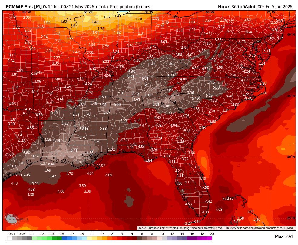
A very wet period is commencing today. Here is the EPS forecast precipitation amounts and anomalies the next 15 days. Hopefully putting a big dent in the drought. Have your umbrellas on hand for a while.
Rain chances continue to look increasingly promising across much of the Southeast/Carolinas heading into late week and the upcoming weekend as a front settles into the region and overall pattern becomes more active.
It likely won’t be a complete washout every day, but multiple rounds of showers/storms could bring some much needed rainfall to areas currently dealing with ongoing drought conditions. #ncwx #scwx #gawx