Rutherford Weather | Stay Ahead of the Storm
Rutherford Weather is here before, during and after impactful or severe weather for Rutherford County, Tennessee with Bryan Barrett, Meteorologist Justin Bailey and a team of meteorologists from Weatherology.
⚠️Weather Update for Tuesday⚠️
We have a chance for more numerous storms tracking through the area tomorrow (Tuesday). While the overall severe risk is on the lower end (a Level 1 out of 5 for the northern third of the county), you'll still want to stay weather-aware.
Here is what you need to know:
🌬️ Main Threat: Low-end chance for damaging wind gusts of 60+ mph.
⚡ Timing: Keep an eye on the sky throughout Tuesday as storm coverage picks up.
Make sure you have a way to receive warnings tomorrow just in case a storm strengths in your neighborhood! 📱⛈️
Well - that didn’t take long!
A Flood Watch has been issued for our area from Monday morning through Monday evening.
Atmospheric conditions are highly favorable for heavy rainfall across Middle Tennessee. While the exact location of the heaviest downpours is still being tracked, excessive runoff could quickly lead to flooding in our local rivers, creeks, streams, and low-lying or flood-prone locations right here in Rutherford County.
🛑 What You Should Do:
Monitor the Forecast: Keep an eye on Rutherford Weather for live updates and be alert for potential Flood Warnings.
Be Prepared: If you live or commute through flood-prone areas, have a plan in place and be ready to act if water starts to rise.
Turn Around, Don't Drown: Never drive through flooded roadways. Most flood-related fatalities happen in vehicles.
#RutherfordWx #TNwx #FloodWatch #SafetyFirst #Murfreesboro #Smyrna #LaVergne
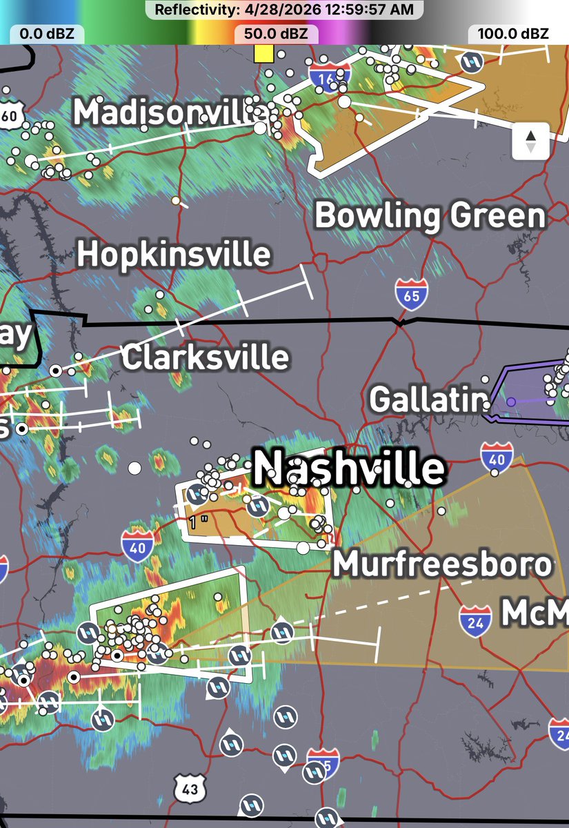
☔ We are tracking a heavy rain threat over the next few days with a sharp southern gradient that we need to watch closely.
The Big Concern:
The rainfall model (video) shows a massive 3 to 5+ inch deluge setting up just to our south and west (near Franklin and Lewisburg). While Murfreesboro is currently on the lighter edge—modeled for 1.21 inches by Tuesday morning—any slight northward shift of just 15–20 miles will pull those torrential 3+ inch totals right into Rutherford County.
Quick Timeline:
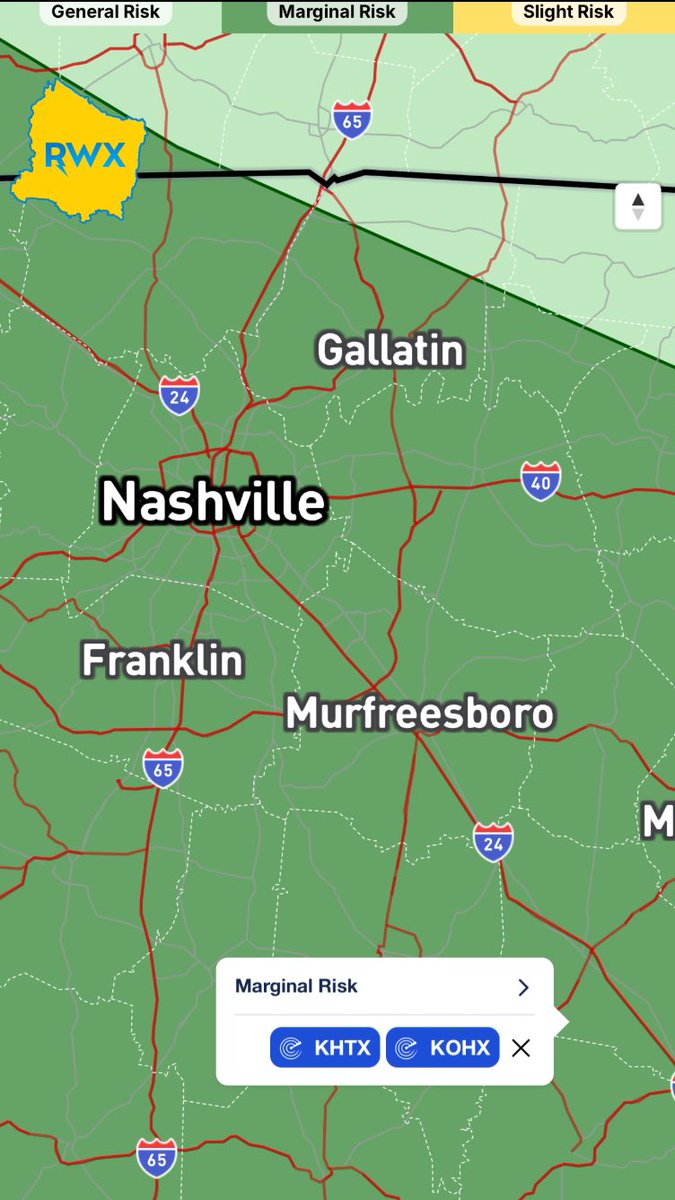
* Sunday, June 7: A Slight Risk is already clipping southern areas like Rockvale and Christiana, with a Marginal Risk elsewhere (1st image).
* Monday, June 8: The Slight Risk expands county-wide as heavy rain moves in (2nd image). Murfreesboro hits 1.15 inches by 5:00 PM, according to the models.
* Tuesday, June 9: The system moves further east, leaving us in a Marginal Risk as it pulls away (3rd image).
Reminder: Atmospheric boundaries wobble, so stay weather-aware! If you see flooded roads, Turn around, don't drown!
We are monitoring the radar for any northward shifts. Stay tuned to Rutherford Weather for updates!
#TNwx #RutherfordTN #MurfreesboroWeather #FlashFloodPreps
🚨 Rutherford Weather is a TAB finalist for Best Local News for the 2nd year in a row! After winning 3 major awards last year, we're ready to keep the streak alive ⛈️🏆
THANK YOU for trusting us during every storm!
This is 1 of 6 nods for WGNS Radio, leading all TN radio & tying TV giants WKRN/WSMV for most in the state!
Story: https://t.co/oA8EEGst9U
Monday is our last day in this sticky, muggy pattern, but it’s going out with a threat of severe weather. Most of Middle TN is under a Level 1 of 5 (Marginal Risk).
⚠️ Quick Details:
Impacts: Damaging wind gusts (main threat) and large hail.
Timing: Round 1 hits 9 AM – 1 PM as a line moves NW to SE. A second round is possible late afternoon/evening, but confidence is low.
The Catch: If the morning storms are strong, they’ll zap the energy for the evening. If morning storms fizzle, evening storms become more likely.
Keep Rutherford Weather handy for the morning commute. Once this clears, the humidity drops! 🌤️
#TNwx #RutherfordWeather
⚡️ Severe weather is possible Friday afternoon into the early evening, and our area is under a 1/5 marginal risk.
Timing:
Friday afternoon through early evening.
Threats:
Damaging wind and heavy rain are the main threats, though there is also a low-end tornado risk.
Please stay weather-aware and have a way to receive alerts.
#SevereWeather #StormWatch #FridayWeather
Good News, Rutherford County! The severe weather threat is fading fast…the WATCH IS CANCELED!
Latest radar and satellite show storms are losing their "fuel" and weakening. This is a great sign that the threat isn't nearly what we thought it could be earlier.
Expect rain to continue overnight, but no severe weather is very minimal. Enjoy the rain…we need it!
Let’s get ready again Rutherford County!
A Severe Thunderstorm Watch is in effect for Rutherford County until 1AM. Scattered hail up to ping-pong ball size possible as well as some scattered gusts to 70 mph. A tornado or two can’t be ruled out.
Storms are popping up all around us here in Rutherford County. One of the strongest, moving east out of Hohenwald at 1AM, is about 2 hours away at its current speed. We will keep you updated!
The forecast remains on track: we are still a few hours away from the arrival of storms.
While it's quiet now, tornado watches and warnings are active to our west.
Expect activity to pick up between 11:00 PM and pre-dawn.
Since this is an overnight event, please ensure you have a way to receive warnings that will wake you up if you go to bed (Weather Radio for example).
If storms reach severe limits, we will go LIVE . Stay weather-aware! 📱⚡
It feels like severe weather season took its sweet time this year, but it’s officially knocking on the door. The SPC has outlined Rutherford County and the western 2/3 of Tennessee in their probabilistic outlook for next Monday and Tuesday. Much of Dixie Alley is under the spotlight, so now is the time to dust off those weather radios and double-check your safety plans. Stay weather aware!