Expect another day of high fire danger, with strong w-sw winds & low relative humidity. Some improvement is forecast for Thu, as a cold front brings cooler air & slightly higher humidity, though the plains may still see elevated fire danger as gusty winds persist. #cowx
Areas of high fire danger will continue today into Wednesday, with west winds gusting as high as 50 mph at times, along with relative humidity dropping below 10 percent each afternoon. Continue to practice fire mitigation and avoid activities that could start a wildfire! #cowx
A Red Flag Warning is in effect for portions of the Plains on Sunday from 10AM to 9PM due to strong southwest winds and very low humidity values. A Fire Weather Watch is in effect for Monday afternoon/evening for Las Animas and Baca Counties. #COWX
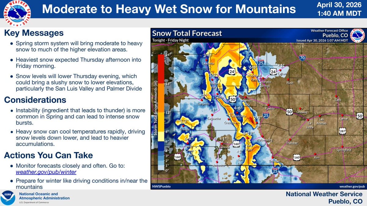
Here is the latest update to the snow forecast! Heaviest amounts over our eastern mountains, with some slushy, lighter snow over the Palmer & San Luis Valley. Be prepared for slick driving conditions! Snow continues through Fri PM. Details at https://t.co/pZtSo4MaKk #cowx
Here is the latest look at some of our incoming winter weather. Expect frequent updates as we continue refining the forecast. Check out the full details at https://t.co/H5rsRPRAf1 #cowx
Critical fire weather conditions will persist across the Upper Arkansas Valley/the San Luis Valley and the srn I-25 corridor on Sat, as strong sw winds and low relative humidity remain in place. Cooler with slightly higher humidity elsewhere. #cowx
Fire Weather continues today & Sat across the region. Southwest winds 15-25 mph with gusts 35-40 mph will prevail today along with very low humidity values. For Saturday, coverage will be limited to the San Luis Valley & gap wind prone areas of the southern I-25 corridor. #COWX
To reduce the risk of wildfire and support public safety, we are planning for a possible Public Safety Power Shutoff (PSPS) beginning on Wednesday, April 22, around 9 a.m. MT for some customers in Garfield, Mesa and Pitkin counties, and around 11 a.m. MT for some customers in Alamosa, Conejos, Costilla, Rio Grande and Saguache counties.
Weather conditions are expected to start improving around 7 p.m. on Wednesday, April 22. Crews will begin restoring power as soon as it is safe to do so.
We also continue to monitor a high wildfire risk event along the northern Front Range expected on Thursday, April 23.
Prepare for potential outages now, especially if you use medical equipment that requires electricity. To learn more about the evolving situation, visit https://t.co/SiA4MnS49l.
You can also visit our outage map for updates: https://t.co/FeysRWk2D0
A passing storm system will bring snow to the mountains and Palmer Divide areas today as a strong cold front pushes southward. Ahead of the front, strong winds and dry conditions are expected across the southern plains, bringing fire weather concerns. #cowx
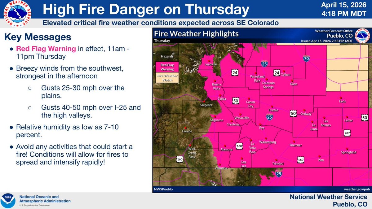
High fire danger is expected Thursday, due to gusty winds and dry surface conditions. Red Flag Warning is in effect for most of our area. Make sure to avoid any actions that could start a fire! #cowx
The start of the week brings another day of dry and windy conditions, which means another high fire danger day. A Red Flag Warning is in effect for much of the area today, so please continue to avoid activities that could start a wildfire! #cowx#firewx
Warmer than normal temperatures and dry, windy conditions are expected for tomorrow. Red Flag Warnings remain in effect for much of the area. Please avoid activities that could start a wildfire! #cowx
Fire danger increases across the region on today, as increasing westerly flow combines with critically dry conditions. Please use caution to avoid any activities which could spark a wildfire on Monday. #cowx
🚩Red Flag Warning for the San Luis Valley floor and the areas shaded in red below from noon - 7 PM.
Please avoid any activities that can spark a wildfire 🔥
Red Flag Warnings and near record temperatures have snuck their way right back into our weekend forecast. Please take extra care not to start a wildfire today!! #cowx
Red Flag Warnings are in place across much of the area this afternoon and evening. Record setting heat is also expected yet again today. A cold front arrives later this afternoon/evening, which will usher in gusty north winds and cooler temperatures for our Friday. #cowx
High Fire Danger is expected across the San Luis Valley and Fremont County today, with more widespread critical fire weather conditions possible tomorrow. Please avoid any activities that could start a wildfire! #cowx