10:15 PM: Monitoring outflow boundary from storms moving south from the Big Country. Activity may slide into portions of the Hill Country and Southern Edwards Plateau but struggles to reach elsewhere. Winds pick up along and behind the outflow, up to around 50 mph for some. #txwx
Seasonably hot with no rain next 7 days. Highs will range from the 90s and triple digits along the Rio Grande Plains, with peak heat index values ranging from 100 to 106. Remember to practice heat safety and stay hydrated! #txwx
Warm, humid tonight with late low clouds. Summer heat will maintain all of next week with highs in the low-to-upper 90s (up to 103°F in Del Rio). When humidity is factored in, afternoon heat indices will range from 100 to 107°F for most locations, with no rain expected. #txwx
A Heat Advisory is in effect Today from NOON to 8 PM. Peak heat indices between 102°F and 112°F are expected. Please stay hydrated, limit outdoor activities, and check on vulnerable neighbors. Stay safe. #txwx
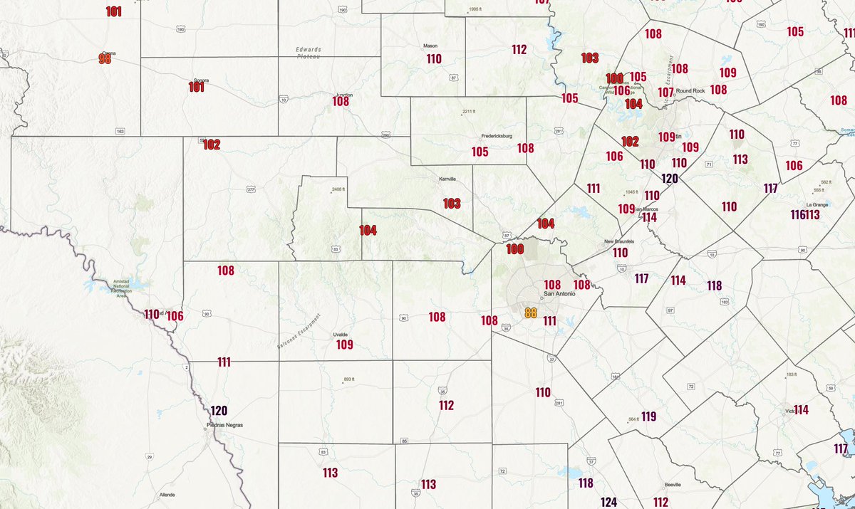
Here is a look at the current heat indices across South-Central Texas. Most ranging in the 105 to 115 degree range with a few locations higher and lower. Ignore the 88 degree reading in southwest San Antonio as that value is erroneous. Stay safe by practicing heat safety! #txwx
**EXTREME HEAT WARNING**
The National Weather Service in Austin/San Antonio has issued a Extreme Heat Warning for Williamson Hays Travis Bastrop Lee Uvalde Medina Bexar Comal Guadalupe Caldwell Fayette Maverick Zavala Frio Atascosa Wilson Karnes Gonzales De Witt Lavaca Dimmit Counties.
...EXTREME HEAT WARNING IS IN EFFECT FROM NOON TODAY TO 8 PM CDT THIS EVENING...
WHAT...Dangerously hot conditions with heat index values of 113-118 expected.
WHERE...A portion of south central Texas.
WHEN...From noon today to 8 PM CDT this evening.
IMPACTS...Heat related illnesses increase significantly during extreme heat and high humidity events.
PRECAUTIONARY/PREPAREDNESS ACTIONS...
Drink plenty of fluids, stay in an air-conditioned room, stay out of the sun, and check up on relatives and neighbors.
Do not leave young children or pets in unattended vehicles. Car interiors will reach lethal temperatures in a matter of minutes.
To reduce risk during outdoor work, the Occupational Safety and Health Administration recommends scheduling frequent rest breaks in shaded or air conditioned environments. Anyone overcome by heat should be moved to a cool and shaded location. Heat stroke is an emergency!
Thursday, June 18th, will be the hottest day during this time period with heat index values rising above 100°F, with some locations exceeding 115°F, with those temperatures starting to be near the following locations.
Eagle Pass and Crystal City starting at 10:00AM
La Pryor, Uvalde, Sabinal, Brackettville, and Del Rio starting at 11:00AM
Comstock starting at 12:00PM
The hottest temperatures will be from early afternoon into the late evening hours.
The Extreme Heat Warning is still in effect until 8:00PM Thursday, with heat index values expected to be near to or above 115°F.
The estimated heat indexes based on future models will be listed below with the time frame on when it will be at its highest in each location.
Dimmit County
Catarina, 121°F at 6:00PM
Carrizo Springs, 118°F at 7:00PM
Big Wells, 123°F at 4:00PM
Asherton, 118°F at 7:00PM
Zavala County
Crystal City, 119°F at 7:00PM
La Pryor, 116°F at 6:00PM
Batesville, 118°F at 4:00PM
Uvalde County
Uvalde, 115°F at 4:00PM
Knippa, 114°F from 3:00 to 4:00PM
Sabinal, 112°F at 5:00PM
Utopia, 114°F at 5:00PM
Kinney County
Brackettville, 113°F from 3:00 to 4:00PM
Maverick County
Quemado, 112°F at 4:00PM
Eagle Pass, 115°F at 3:00PM
Chula Vista, 115°F at 7:00PM
El Indio, 114°F at 4:00PM
Val Verde County
Del Rio, 115°F at 5:00PM
Comstock, 109°F from 3:00 to 4:00PM
Remember to stay hydrated, limit prolonged outdoor exposure, and check on those most vulnerable to heat.
**EXTREME HEAT WARNING**
THE NATIONAL WEATHER SERVICE IN AUSTIN/SAN ANTONIO HAS ISSUED A EXTREME HEAT WARNING FOR THE FOLLOWING COUNTIES:
ATASCOSA, BASTROP, BEXAR, CALDWELL, COMAL, DE WITT, DIMMIT, FAYETTE, FRIO, GONZALES, GUADALUPE, HAYS, KARNES, LAVACA, LEE, MAVERICK, MEDINA, TRAVIS, UVALDE, WILLIAMSON, WILSON, AND ZAVALA COUNTIES.
...EXTREME HEAT WARNING IS IN EFFECT FROM NOON TO 8 PM CDT THURSDAY...
WHAT...Dangerously hot conditions with heat index values up to 112 expected.
WHERE...The Hill Country, Edwards Plateau, and northern Rio Grande Plains.
WHEN...From noon to 8 PM CDT Thursday.
IMPACTS...Heat related illnesses increase significantly during extreme heat and high humidity events.
PRECAUTIONARY/PREPAREDNESS ACTIONS...
Drink plenty of fluids, stay in an air-conditioned room, stay out of the sun, and check up on relatives and neighbors.
Do not leave young children or pets in unattended vehicles. Car interiors will reach lethal temperatures in a matter of minutes.
To reduce risk during outdoor work, the Occupational Safety and Health Administration recommends scheduling frequent rest breaks in shaded or air conditioned environments. Anyone overcome by heat should be moved to a cool and shaded location. Heat stroke is an emergency!