GPR can support a more detailed understanding of subsurface stratigraphy in placer deposit exploration. A pulseEKKO® survey revealed the fluvial architecture of a buried paleovalley.
Learn more: https://t.co/rpo3VImweE
NOGGIN® is an adaptable GPR platform designed to support efficient data collection and clearer subsurface interpretation. Easily add another frequency, a new configuration or accessories to your existing Noggin system.https://t.co/zGGs8djDVJ
Did you know that the #SPIDAR NIC-500X allows any combination up to 8 pulseEKKO #GPR transmitters (Tx) and receivers (Rx) to be networked together, and any Tx can fire to one or more Rxs simultaneously?
Learn more: https://t.co/YYjrkdyMwt
Join us for an overview of Sensors & Software’s versatile NOGGIN® GPR systems, including the new SplitView™ feature.
📅 Two sessions available (same content, choose the time that works best for you):
8 am ET: https://t.co/BJ005MYGb4
2 pm ET: https://t.co/HQ6xiWCpGk
GPR can support the identification and mapping of metallic and non‑metallic pipes and cables, including PVC, asbestos cement, and utilities with compromised tracer wires.
Learn more: https://t.co/QWWiSU3K9W
🎉 Happy Victoria Day! Sensors & Software will be closed on Monday, May 18th and will resume regular business hours on Tuesday, May 19th. We wish everyone a safe and enjoyable holiday.
Did you know the #SPIDAR NIC-500X can connect up to 8 pulseEKKO #GPR transmitters (Tx) and receivers (Rx)? Even better—any transmitter can send signals to one or multiple receivers at the same time.
Learn More: https://t.co/YYjrkdyMwt
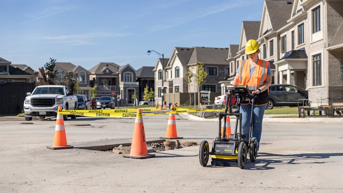
We’re introducing the new Noggin® GPR System, featuring SplitView.
SplitView is designed to display a real-time cross-section of GPR data alongside a map view of survey paths and user-added interpretations.
Learn more: https://t.co/cvcQiO6Azk
Did you know that the #SPIDAR NIC-500X allows any combination up to 8 pulseEKKO #GPR transmitters (Tx) and receivers (Rx) to be networked together, and any Tx can fire to one or more Rxs simultaneously?
Ground‑penetrating radar (GPR) can offer valuable insight into subsurface conditions—especially in critical infrastructure settings.
Read the full story:
https://t.co/tw7BiWWGgS
Sensors & Software’s GPR-SG accessory bundles provide an out-of-the-box solution to integrate high-accuracy GNSS positioning into your GPR data.
Learn more about GPR-SG: https://t.co/SnhYX1yqjq
We’re excited to announce that we’ll be participating in the 2026 CGA Conference & Expo, taking place April 27–30, 2026 in Colorado Springs, CO.
If you’ll be there, stop by our booth.
https://t.co/ijawvk4qZb
Participe en el próximo curso impartido de forma presencial de GPR organizado por Geological Society of America (GSA) e impartido por Sensors & Software.
📅 Abril 21 – GPR Short Course
🔗 https://t.co/3BSQSRv1gC
Join our NULCA‑accredited, in‑person training courses in Mississauga to build foundational skills in locating and mapping underground utilities using GPR and Precision Locators.
📅 GPR Training – April 27
📅 Precision Locators – April 28
https://t.co/LrrFYkvxUC
Did you know the #SPIDAR NIC-500X allows up to 8 pulseEKKO #GPR transmitters and receivers to be networked together, with any transmitter able to fire to one or more receivers simultaneously?
Learn more: https://t.co/AF8ub42BiM
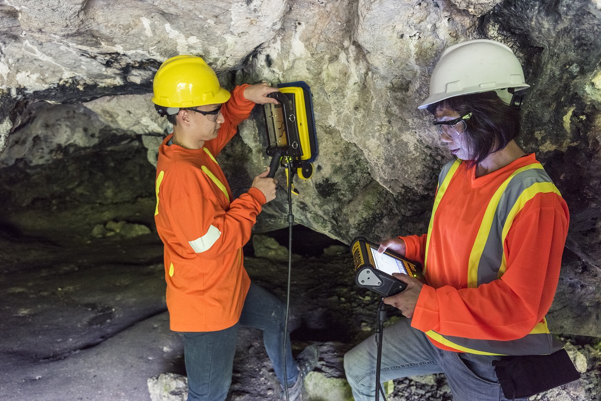
Did you know? The flexible & adaptable #NOGGIN#GroundPenetratingRadar can be used in a variety of configurations to support different project needs and applications.
Learn more: https://t.co/zGGs8djDVJ
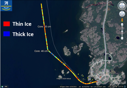
Collecting ice thickness data with GPR and GNSS can support a more detailed understanding of evolving ice conditions. Transforming field measurements into mapped outputs and summary reports helps teams to more clearly review conditions along their route.
https://t.co/6PsTnMMRCR
Environmental site assessments often require sites to be cleared for borehole drilling. In this case study, #GPR was used to map storage tank locations at a gas station to allow borehole soil sampling to be safely performed.
https://t.co/g1LEkS5U0E
Curious about ice survey results?
Following data collection, the IceMap™ GPR summary report is designed to efficiently highlight key survey statistics — including minimum and maximum ice thickness and areas of comparatively thinner ice.
Learn more:
https://t.co/6PsTnMMRCR
In a Subsurface Utility Engineering (SUE) project supporting a municipal water line installation, Sensors & Software GPR technology was used to inform planning decisions where existing records were limited.
Learn more:
https://t.co/xkXXS4pvY3