Exploring a very detailed shaded map of Baltimore, Maryland, US. The full map is 24000 x 24000 pixels with 0.5 m resolution.
Data source: U.S. Geological Survey, National Geospatial Program.
#geography#gischat#cartography#GIS#shadedmaps
A very detailed shaded map of Baltimore, Maryland, US. The full map is 24000 x 24000 pixels with 0.5 m resolution.
Data source: U.S. Geological Survey, National Geospatial Program.
#geography#gischat#cartography#GIS#shadedmaps
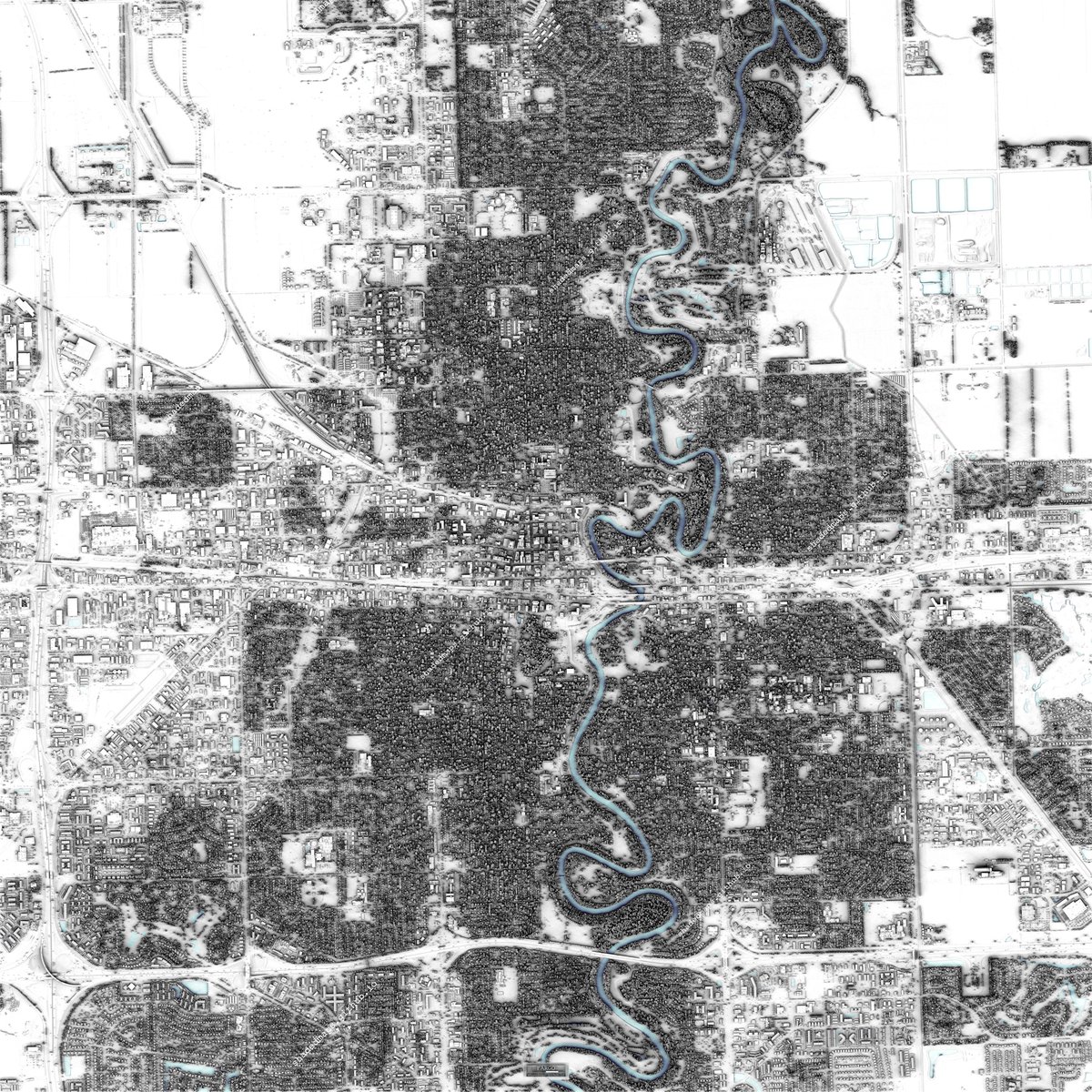
Exploring a very detailed shaded map of Minneapolis, Minnesota, US. The full map is 16000 x 16000 pixels with 0.5 m resolution.
Data source: U.S. Geological Survey, National Geospatial Program.
#gischat#shadedrelief#dataviz#cartography#geography
A very detailed shaded map of Minneapolis, Minnesota, US. The full map is 16000 x 16000 pixels with 0.5 m resolution.
Data source: U.S. Geological Survey, National Geospatial Program.
#gischat#shadedrelief#dataviz#cartography#geography
Exploring a very detailed shaded map of Fargo, North Dakota, US. The full map is 18000 x 18000 pixels with 0.5 m resolution.
Data source: U.S. Geological Survey, National Geospatial Program.
#cartography#gischat#geography#shadedrelief#maps
A very detailed shaded map of Fargo, North Dakota, US. The full map is 18000 x 18000 pixels with 0.5 m resolution.
Data source: U.S. Geological Survey, National Geospatial Program.
#cartography#gischat#geography#shadedrelief#maps
Exploring a very detailed shaded map of New York City [Manhattan], New York, US. The full map is 33000 x 66000 pixels with 1 ft resolution.
Data source: NYC Office of Technology and Innovation (OTI).
#GIS#maps#dataviz#shadedrelief#shadedmaps
A very detailed shaded map of New York City [Manhattan], New York, US. The full map is 33000 x 66000 pixels with 1 ft resolution.
Data source: NYC Office of Technology and Innovation (OTI).
#GIS#maps#dataviz#shadedrelief#shadedmaps
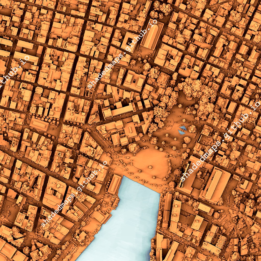
Exploring a very detailed shaded map of Monte Carlo, Monaco. The full map is 15092 x 16000 pixels with 0.5 m resolution.
Data source: Institut national de l'information géographique et forestière.
#lidar#cartography#shadedmaps#gischat#shadedrelief
A very detailed shaded map of Monte Carlo, Monaco. The full map is 15092 x 16000 pixels with 0.5 m resolution.
Data source: Institut national de l'information géographique et forestière.
#lidar#cartography#shadedmaps#gischat#shadedrelief
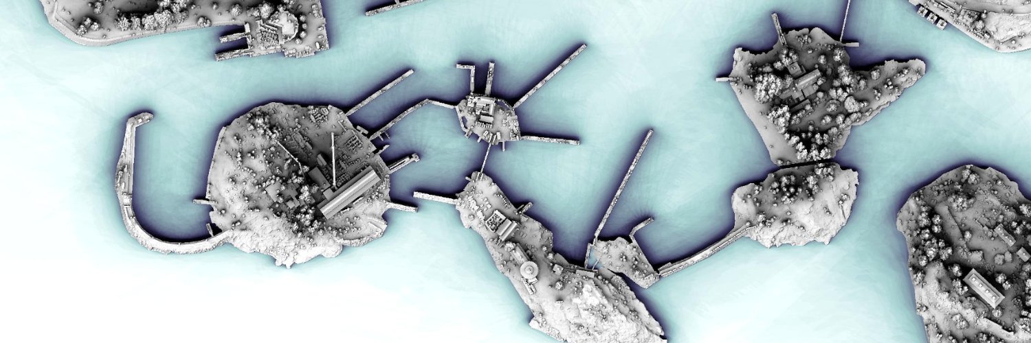
Exploring a very detailed shaded map of Pointe-à-Pitre, Guadeloupe, France. The full map is 24000 x 20000 pixels with 0.5 m resolution.
Data source: Institut national de l'information géographique et forestière.
#shadedmaps#geography#GIS#cartography#dataviz
A very detailed shaded map of Pointe-à-Pitre, Guadeloupe, France. The full map is 24000 x 20000 pixels with 0.5 m resolution.
Data source: Institut national de l'information géographique et forestière.
#shadedmaps#geography#GIS#cartography#dataviz
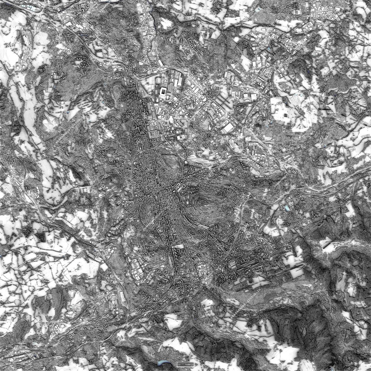
Exploring a very detailed shaded map of Saint-Étienne, France. The full map is 20000 x 20000 pixels with 0.5 m resolution.
Data source: Institut national de l'information géographique et forestière.
#shadedrelief#shadedmaps#geography#cartography#dataviz
A very detailed shaded map of Saint-Étienne, France. The full map is 20000 x 20000 pixels with 0.5 m resolution.
Data source: Institut national de l'information géographique et forestière.
#shadedrelief#shadedmaps#geography#cartography#dataviz
A very detailed shaded map of Metz, France. The full map is 20000 x 20000 pixels with 0.5 m resolution.
Data source: Institut national de l'information géographique et forestière.
#shadedmaps#shadedrelief#lidar#maps#GIS
Exploring a very detailed shaded map of Metz, France. The full map is 20000 x 20000 pixels with 0.5 m resolution.
Data source: Institut national de l'information géographique et forestière.
#shadedrelief#cartography#dataviz#gischat#geography
Exploring a very detailed shaded map of Montreal, Canada. The full map is 22386 x 24403 pixels with 0.5 m resolution.
Data source: Government and Municipalities of Québec.
#cartography#GIS#geography#gischat#shadedrelief
A very detailed shaded map of Montreal, Canada. The full map is 22386 x 24403 pixels with 0.5 m resolution and is available at https://t.co/hs0XhI8Ann
Data source: https://t.co/jzhgJTV2bR [Government and Municipalities of Québec].
#gischat#maps#shadedrelief#GIS#shadedmaps
Diagonal panning video from a very detailed shaded map of Limoges, France. The full map is 16000 x 16000 pixels with 0.5 m resolution and is available at https://t.co/hs0XhI8Ann
Data source: https://t.co/RAMiVVJQQR [Institut national de l'information géographique et forestière].


![ShadedMaps's tweet photo. A very detailed shaded map of New York City [Manhattan], New York, US. The full map is 33000 x 66000 pixels with 1 ft resolution.
Data source: NYC Office of Technology and Innovation (OTI).
#GIS #maps #dataviz #shadedrelief #shadedmaps https://t.co/IMBOgh4Ako](https://pbs.twimg.com/media/HKdGYebXIAAXqA4.jpg)
![ShadedMaps's tweet photo. A very detailed shaded map of New York City [Manhattan], New York, US. The full map is 33000 x 66000 pixels with 1 ft resolution.
Data source: NYC Office of Technology and Innovation (OTI).
#GIS #maps #dataviz #shadedrelief #shadedmaps https://t.co/IMBOgh4Ako](https://pbs.twimg.com/media/HKdGYLRWoAAjxne.jpg)
![ShadedMaps's tweet photo. A very detailed shaded map of New York City [Manhattan], New York, US. The full map is 33000 x 66000 pixels with 1 ft resolution.
Data source: NYC Office of Technology and Innovation (OTI).
#GIS #maps #dataviz #shadedrelief #shadedmaps https://t.co/IMBOgh4Ako](https://pbs.twimg.com/media/HKdGXmaXkAAFJJq.jpg)


![ShadedMaps's tweet photo. A very detailed shaded map of Montreal, Canada. The full map is 22386 x 24403 pixels with 0.5 m resolution and is available at https://t.co/hs0XhI8Ann
Data source: https://t.co/jzhgJTV2bR [Government and Municipalities of Québec].
#gischat #maps #shadedrelief #GIS #shadedmaps https://t.co/DqUz8x8yR0](https://pbs.twimg.com/media/HI6k1RPXAAEz6Uw.jpg)
![ShadedMaps's tweet photo. A very detailed shaded map of Montreal, Canada. The full map is 22386 x 24403 pixels with 0.5 m resolution and is available at https://t.co/hs0XhI8Ann
Data source: https://t.co/jzhgJTV2bR [Government and Municipalities of Québec].
#gischat #maps #shadedrelief #GIS #shadedmaps https://t.co/DqUz8x8yR0](https://pbs.twimg.com/media/HI6k1AMWwAAfjvs.jpg)
![ShadedMaps's tweet photo. A very detailed shaded map of Montreal, Canada. The full map is 22386 x 24403 pixels with 0.5 m resolution and is available at https://t.co/hs0XhI8Ann
Data source: https://t.co/jzhgJTV2bR [Government and Municipalities of Québec].
#gischat #maps #shadedrelief #GIS #shadedmaps https://t.co/DqUz8x8yR0](https://pbs.twimg.com/media/HI6k0UwXEAEIvEv.jpg)


![ShadedMaps's tweet photo. A very detailed shaded map of New York City [Manhattan], New York, US. The full map is 33000 x 66000 pixels with 1 ft resolution.
Data source: NYC Office of Technology and Innovation (OTI).
#GIS #maps #dataviz #shadedrelief #shadedmaps https://t.co/IMBOgh4Ako](https://pbs.twimg.com/media/HKdGY31WgAAEfbQ.jpg)


![ShadedMaps's tweet photo. A very detailed shaded map of Montreal, Canada. The full map is 22386 x 24403 pixels with 0.5 m resolution and is available at https://t.co/hs0XhI8Ann
Data source: https://t.co/jzhgJTV2bR [Government and Municipalities of Québec].
#gischat #maps #shadedrelief #GIS #shadedmaps https://t.co/DqUz8x8yR0](https://pbs.twimg.com/media/HI6k1jdXAAAwJ0O.jpg)


