Dry air and gusty west winds increase the threat of quick brush fire spread this afternoon and evening. Be careful with any spark or heat producing tools. If a brush fire is detected, dial 9-1-1 without delay.
***FLOOD WATCH*** is in effect tonight into Thursday. Another round of heavy rain is expected for our area. Expect 2-3" with higher amounts possible. Check to make sure drains are clear and test sump pumps if you have one.
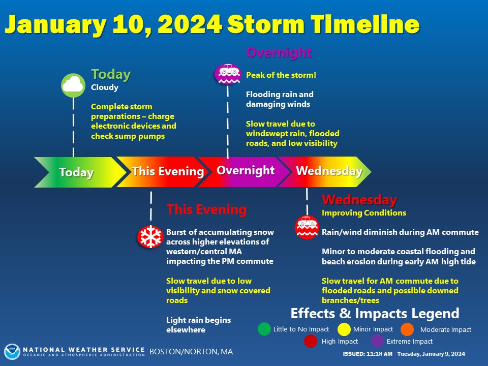
Storm Impacts:
- Burst of accumulating snow in higher elevations.
- Flooding rain & damaging wind overnight.
- Coastal flooding early Wed AM
Conditions improve quickly for 2nd half of Wed AM commute but plan on extra travel time! https://t.co/aqcnsXtpuk
#ctwx#mawx#riwx
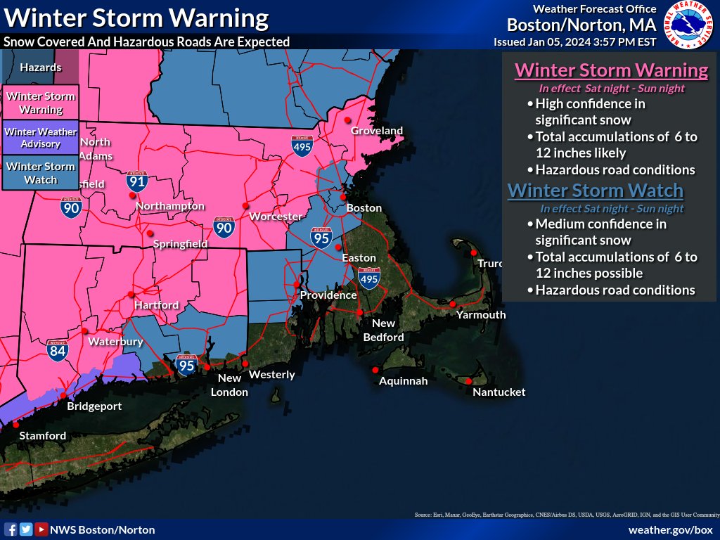
Winter Storm Warning
* High Confidence in 6-12 inches of snow
* Hazardous travel expected
Winter Storm Watch
* Medium Confidence in 6-12 inches of snow
* Rain snow line uncertain east of I-95
* Flash freeze possible late Sunday afternoon
* Hazardous travel likely
Good morning. As you begin your AM commute, use extra caution as trash carts and branches are in roadways in some locations. At this time, 69 RIE customers are without power and 1.49" of rain has fallen at the EOC weather station. Highest gusts are 42MPH so far.
***HIGH WIND WARNING*** in effect for Monday from 5AM til 7PM. Sustained winds of 20 - 30MPH will gust to 50 MPH+ at times. In addition, heavy rains accompanying the wind may result in poor drainage flooding and river rise. Use extreme caution throughout the day.
***FLOOD WATCH & HIGH WIND WATCH*** for tommorow night into Monday night. A repeat performance of last Sunday's storm plays out again this week. Prepare your family and homes for poor drainage flooding and wind damage. Take down seasonal decorations that can catch the wind.
Good morning. Please use caution on roadways this AM. There is some ponding on roadways due to rain and some debris from trees and overturned trash carts due to the wind. A Flood Watch continues until 7pm this evening.
🌬️ Not to be a Grinch, but with tomorrow's High Wind Watch in NYC, now is the perfect time to secure any outdoor furnishings and holiday decor that could become dislodged.
Let’s make sure to keep any Santas on the loose to today only. 🤞
***WIND ADVISORY*** in effect 7pm tonight until 1pm Monday. South winds 20 to 30MPH will gust to 50MPH. A multi-hazard storm system will bring high wind and heavy rain later today. Prepare your homes and be ready should a power outage occur.
Today we remember @Smithfield_PD Sgt. Norman Vezina, who drowned 55 years ago today. After a young boy fell through the ice at a local pond, Sgt. Vezina entered the water to rescue him, because helping people is what police officers do. Sgt. Vezina is a true Smithfield hero.
***FLOOD WATCH*** in effect from Sunday afternoon til Monday evening for our area. Multi-hazard storm is expected to bring heavy rain and high winds to our area starting later tommorow. Remain alert for changes in the forecast.
IMPORTANT: On Wednesday, Oct. 4th at 2:20 p.m. ET, there will be a nationwide emergency alert test on cell phones, wireless devices, radios, and TVs.
This is a standard test that occurs at least once every three years. No action is needed.
Info & FAQs: https://t.co/KKyrIr4e03
***FLOOD WATCH*** in effect from 11AM today and continuing until Thursday morning. More periods of heavy rain expected today and into the evening hours which may cause a repeat of Monday's flooding event. Remain vigilant for dangerous conditions throughout today.