High Pressure will gradually build in across the West over the next few days. Daytime temperatures in #SoCal will get back up into the low 80's for LA/OC Metro areas next week, with mid to upper 80's Inland Valleys. Coastal locations will see temps in the 70's thanks to the Marine Layer burning off late there. #CAwx
@davidhp92 Likely the last Pacific storm bringing any showers to SoCal until next Fall. We may get some tropical remnant stuff or stray Monsoon moisture this Summer, but that remains to be seen.
Latest HRRR Simulated Radar depiction 5/28/26 - One last chance for some showers this evening for #SoCal as the upper Low axis moves through the region before shifting East. Clouds decrease tomorrow and temperatures rebound into the weekend. #CAwx
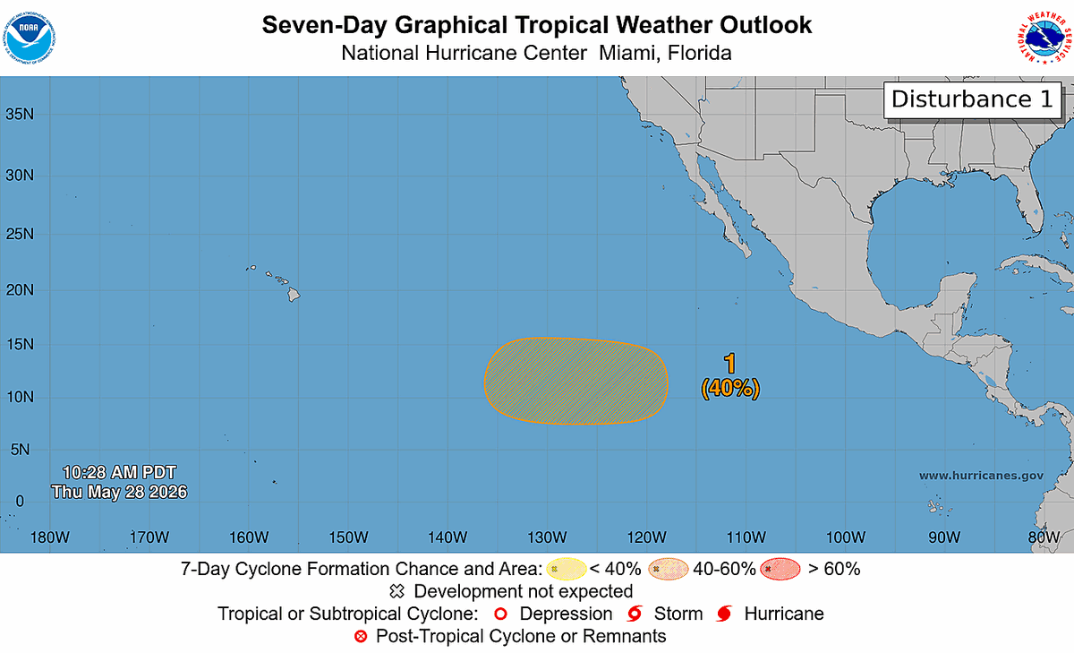
May 28 11 AM PDT: There is a medium chance (40%) of tropical cyclone formation well to the southwest of the Baja California peninsula next week. Visit https://t.co/Oy8uoeRKme for more details.
HRRR Simulated Radar through Friday AM - Chances for drizzle or even a brief shower will continue across #SoCal through Thursday PM before the system clears out, although most locations will remain dry. A warming trend gets underway this weekend as the Low moves off to our East. #CAwx
@PRIFIRE5150@NWSFlagstaff “Change Daily��? It really sounds like you’re thinking of the CPC outlooks (6-10, 8-14 Day, etc) This is the annual Monsoon Outlook (for June though September) put out by the NWS in Arizona every year. CPC data is only one part of the tools they use to come up with it.
Looking like an above average Monsoon season ahead for the interior Southwest including #SoCal Mountains and Deserts.
Likely a better than average shot of rainfall from decaying Tropical systems during late Summer/Early Fall for all of SoCal as we anticipate an active Hurricane Season in the Eastern Pacific thanks to a developing El Niño.
The 2026 Monsoon Outlook. As of late May the odds are tilting toward above average precipitation and temperatures across all of Arizona. Feel free to share/post graphics wherever you like. (graphics shown are in both english and spanish). #azwx
Continued cooler weather across the area will be accompanied by windy conditions across the mountains and deserts. Please drive with care if venturing into these areas 🚗🚚
3KM NAM Simulated Satellite depiction - A cut off Low will spin over Northern California over the next few days. This will strengthen the Marine Layer across #SoCal enough to produce drizzle & light showers during Night & Morning hours through Thursday. #CAwx
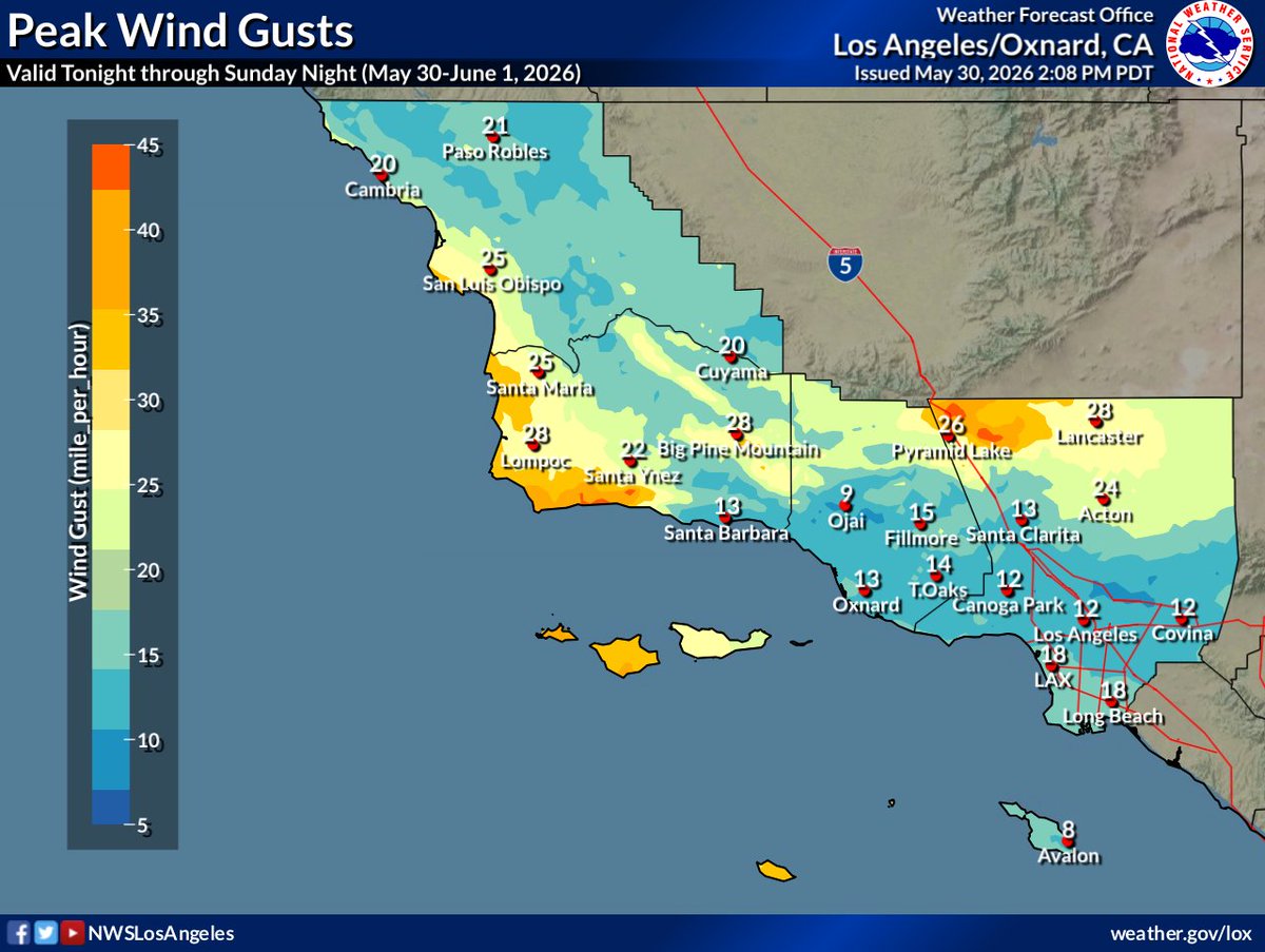
Still looking windy this weekend for #SoCal:
- W-NW wind, gusting 40-65 MPH today-Sun
* Strongest (gusts 55-65 MPH) tonight-Sun Night
* Interior sections as well as SW Santa Barbara county
- Gale force gusts (35-45 kt) across most of the coastal waters. #CAwx
@derek12650901 This is a downsampled image for distribution on Social Media. The full-resolution full disk image is 55.2mb, 21696x21696px @ 72dpi. Downsampling + image compression will do that.
Nice full-disk view of the Earth from GOES-16 today. If you look closely you can see the Marine Layer doing its "May Gray" thing over #SoCal Coastal areas. A typical sight for this time of year.
Here's @NOAASatellites#GOES16 today at local satellite noon (19:00UTC) with the CIMSS Natural Color enhancement. GOES-16 is out of storage for testing for about 2 weeks. Happy #FullDiskFriday!
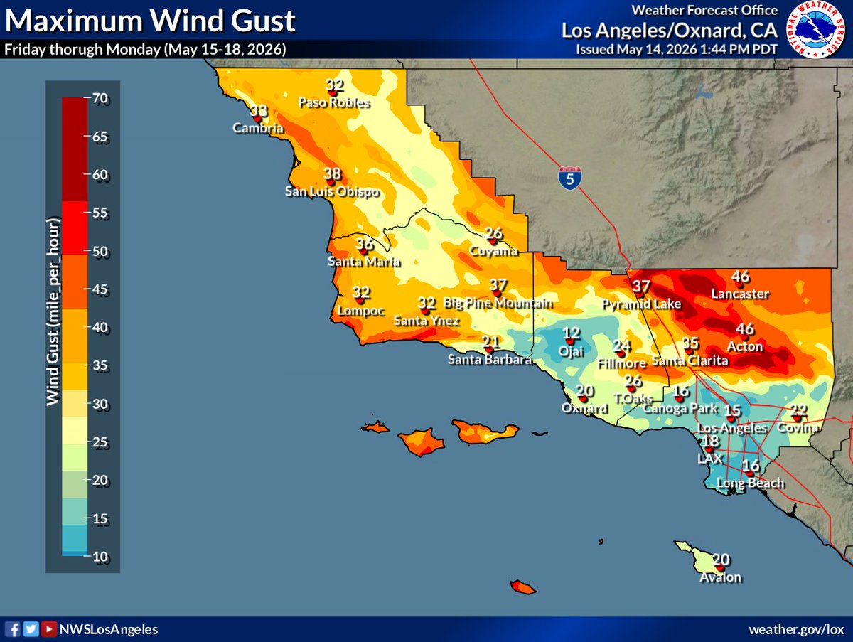
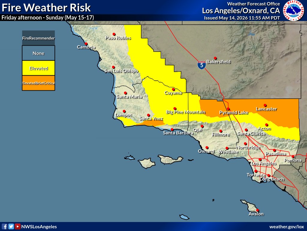
Windy with elevated to brief critical #FireWx conditions this weekend:
* W-NW winds gusting 35-50 MPH interior sections and western Santa Ynez Mountains
* Min RH 8-15% interior sections except 20-30% SW #SantaBarbara county
* High risk of fast-moving grass/shrub fires.
#CAwx
What does #ElNiño really mean for California winter precipitation? In short: it depends on how strong El Niño becomes. Weak events exert only a negligible influence, but strong ones can profoundly increase the likelihood of wet winters and heavy downpours. https://t.co/F4eZljJJzF
'Tis the "May Gray" season - Low Clouds push inland during the overnight hours and linger well into the morning before daytime heating "burns" them off. The cycle repeats again overnight. This will be a common pattern through the next several weeks, which is typical for late Spring in #SoCal. #CAwx
@craigmatthews48@BenNollWeather@washingtonpost And the waters to the North of the Niño region are warmer than even in 2015, which at the time was impressively warm overall compared to previous events.
@craigmatthews48@BenNollWeather@washingtonpost Looks like a lot more warmth is expected in the Niño 3 & Niño 1+2 regions with this event compared to 2015.
But the Eastern Pacific looks to be warmer overall this time compared to any of the previous events, so perhaps less of a temperature gradient to work with.
A rapidly increasing onshore flow and eddy circulation has deepened the marine layer which will cause significant cooling to the valleys and Inland Empire of Southern California today…
10am PDT Temperatures
Yesterday vs Today
VNY 77° / 59° -18°
ONT 79° / 65° -14°
RAL 82° / 63° -19°
@NWSLosAngeles@NWSSanDiego