@SpatialManager - WFS vectorial data in DWG - New Zealand Land Information
Access and import authoritative LINZ (Land Information New Zealand) vector into your DWG
Available for @AutoCAD, @BricsCAD, @ZWCAD, @GstarCAD and @Desktop
Blog entry and video: https://t.co/jffNZS8x8R
@SpatialManager - Create polygons from points
Generates polygons (closed polylines) by sequentially joining the individual points that define their perimeter
Available for @AutoCAD, @BricsCAD, @ZWCAD and @GstarCAD
Blog post and video: https://t.co/otceWsNi23
@SpatialManager - Simplify polylines
Reduces the vertices in polylines or polygons to simplify their geometry, optimizing complexity while preserving the overall shape
Available for @AutoCAD, @BricsCAD, @ZWCAD and @GstarCAD
Blog post and video: https://t.co/0Pb5Q2NjTF
@SpatialManager 10.5 ready for @GstarCAD 2026 SP3
The recently released version 10.5 of ‘Spatial Manager’ is the first one compatible with GstarCAD 2026 SP3
Blog post: https://t.co/BySJb2IflZ
@SpatialManager - Envelope of geometries
Generates an envelope or bounding box for the selected geometries, representing the smallest rectangle that completely contains each object
Available for @AutoCAD, @BricsCAD, @ZWCAD and @GstarCAD
Blog and visdeo: https://t.co/1BBP4j6R7J
@SpatialManager for @AutoCAD 2027 compatible
The latest ‘Spatial Manager’ version (10.4) has been recently released and it is ‘AutoCAD 2027’ compatible
@SpatialManager - Create polylines from points
Converts individual points into connected polylines
Available for @AutoCAD, @BricsCAD, @ZWCAD and @GstarCAD
Blog post and video: https://t.co/lOhKX1VvSe
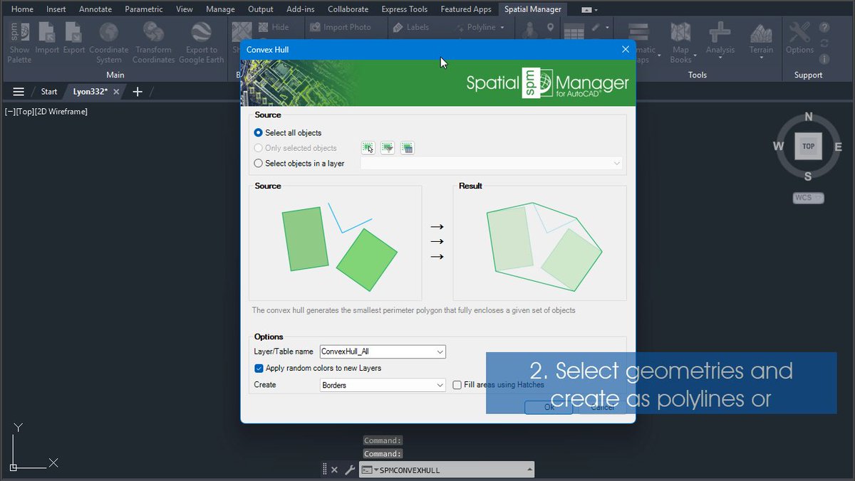
@SpatialManager - Create convex hull of geometries
Creates the smallest convex polygon that fully encloses a selected set of geometries
Available for @AutoCAD, @BricsCAD, @ZWCAD and @GstarCAD
Blog post and video: https://t.co/AkDPNe9iHC
@SpatialManager - Create legend for thematic map in DWG
Inserts a thematic map legend directly into the drawing
Available for @AutoCAD, @BricsCAD, @ZWCAD and @GstarCAD
Blog post and video: https://t.co/mRyhyMzMCl
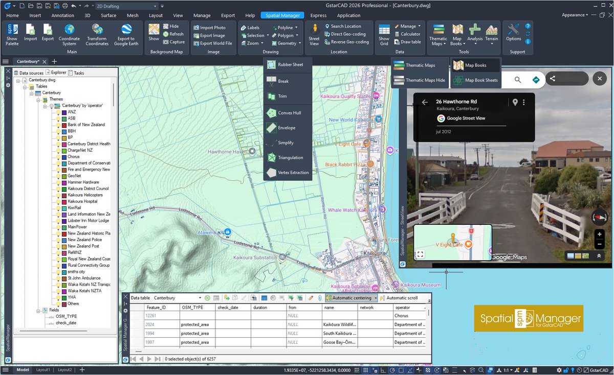
@SpatialManager - Import New Zealand Land Information in DWG
Download and import official Land Information New Zealand (LINZ) data into a DWG
Available for @AutoCAD, @BricsCAD, @ZWCAD, @GstarCAD and @Desktop
Blog post and video: https://t.co/42Bnp6PgO6
@SpatialManager - Trim geometries
Allows a closed boundary to be used as a trimming edge to cut intersecting geometries
Available for @AutoCAD, @BricsCAD, @ZWCAD and @GstarCAD.
Blog post and video: https://t.co/tX4jJsp72P
@SpatialManager - Segmentize polylines and split at intersections
This tool identifies intersections within complex linear geometries and automatically splits them
Available for @AutoCAD, @BricsCAD, @ZWCAD and @GstarCAD
Blog post and video: https://t.co/Cx6db4F9g1
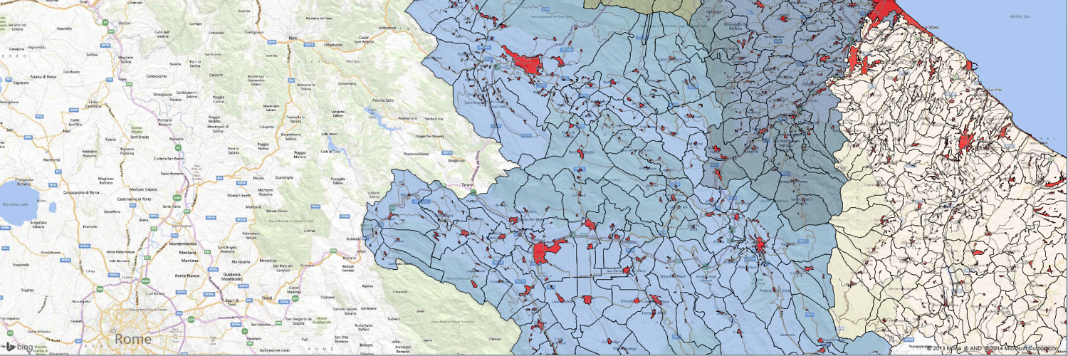
@SpatialManager - Color objects by their data in DWG
Thematic Maps allow you to view objects colored by their data values
Available for @AutoCAD, @BricsCAD, @ZWCAD and @GstarCAD
Blog post and video: https://t.co/VuOJcKuaop
@SpatialManager - Background maps in multiple views in DWG/DXF
Background maps can be displayed simultaneously in multiple views
Available for @AutoCAD, @BricsCAD, @ZWCAD and @GstarCAD
Blog post and video: https://t.co/QB5cGIl6i2
@SpatialManager - Create sheets for a map book in DWG or DXF
Create sheets for map books in a grid pattern or optimized for the best fit
Available for @AutoCAD, @BricsCAD, @ZWCAD and @GstarCAD
Blog entry and video: https://t.co/ePGdHpSnfK
@SpatialManager 10.3 ready for @GstarCAD 2026 SP2
The recently released version 10.3 of ‘Spatial Manager’ is the first one compatible with GstarCAD 2026 SP2
Blog entry and links: https://t.co/7LCez3BM6w
@SpatialManager - Vertex extraction
The Vertex Extraction tool creates individual point features from the vertices of existing geometries
Available for @AutoCAD, @BricsCAD, @ZWCAD and @GstarCAD
Blog post and video: https://t.co/iLzPhUoIzA