Day one of the Commonwealth MDA Summit in Vancouver, well underway. Good conversations on deceptive vessel behaviour, AIS gaps, and building a fuller operational picture from satellite imagery and AI. More sessions ahead, then day two tomorrow.
We are very pleased to have supported the @HighNorthNews' latest investigation, authored by @malte_humpert, into renewed movement around Russia's sanctioned Arctic LNG 2 project.
The analysis examines the first Train 3 construction modules to leave China in nearly two years, tracking their journey toward the Russian Arctic aboard sanctioned heavy-lift vessels. Vessel-detection data from SynMax's maritime domain awareness platform, Theia, was instrumental in identifying the heavy-lift barge and tracking the transfer of the modules between Chinese ports before they were loaded aboard oceangoing transport vessels.
SynMax is pleased to be attending the Commonwealth Maritime Domain Awareness Summit 2026 in Vancouver, Canada, on 3–4 June.
Hosted by @CommonwealthSy, the summit brings together maritime authorities, policymakers, naval leaders, and industry experts to explore the technologies, partnerships, and information-sharing frameworks shaping the future of #MaritimeDomainAwareness.
If you'll be attending the summit and would like to connect with our team, please reach out via DM. We look forward to seeing you in #Vancouver.
#MaritimeDomainAwareness #MaritimeSecurity #MaritimeIntelligence
SynMax is delighted to be attending Posidonia 2026 at the Metropolitan Expo in Athens, Greece, from the 1st to the 5th of June, alongside our partners @LLIntelligence .
One of the world's most renowned shipping exhibitions, Posidonia brings together maritime professionals from across the globe. It is a privilege to be among them, and we look forward to connecting with the wider maritime community across the week.
Visitors can find us at the Lloyd's List Intelligence (LLI) booth, stand 2.203 in Hall 2, where our team will be on hand to discuss our partnership, through which we provide LLI customers with access to satellite intelligence reports, supporting with deeper visibility when investigating incidents or uncovering increasingly deceptive shipping practices.
If you would like to arrange a meeting with our maritime SMEs, please don't hesitate to reach out directly via DM. We look forward to seeing you in Athens.
@PosidoniaEvents
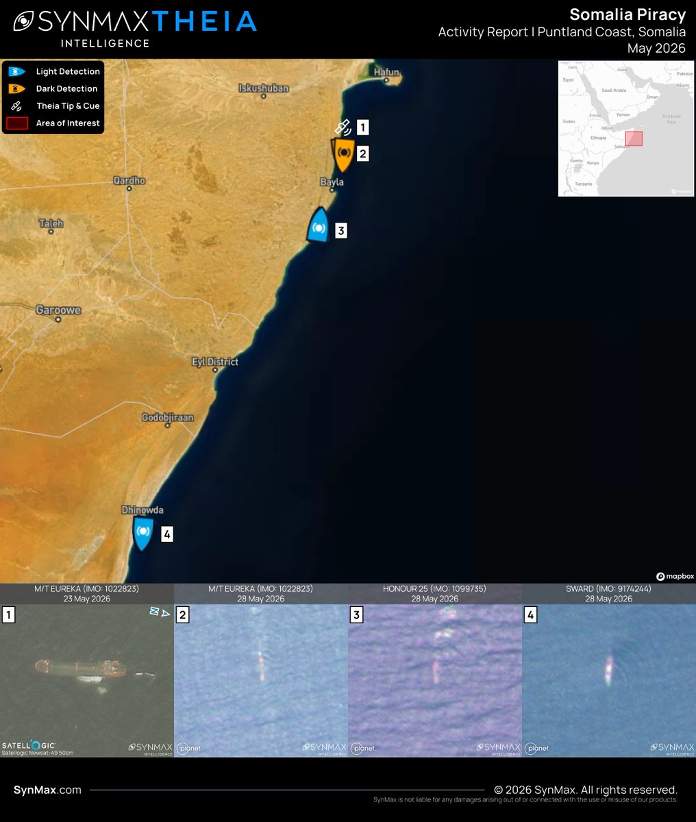
Between the 21st of April and the 2nd of May 2026, three commercial vessels were hijacked off the coast of Somalia and Yemen in a significant resurgence of Somali piracy, assessed to be highly likely carried out by Somali pirate action groups (PAGs) operating from the Puntland coast.
The HONOUR 25 (IMO 1099735), the SWARD (IMO 9174244), and the M/T EUREKA (IMO 1022823) remain under pirate control. SynMax's maritime domain awareness platform, Theia, has tracked the vessels throughout their ordeals, detecting each off the Puntland coast as recently as the 28th of May.
The HONOUR 25 (IMO 1099735) is a Palau-registered product tanker. She was seized on the 21st of April while en route from Berbera, Somaliland, to Mogadishu, while laden with refined oil. Theia detected her on the 28th of May, anchored off the Puntland coast south of Bayla.
On the 26th of April, the SWARD (IMO 9174244), a 100-meter general cargo ship built in 1998 and flagged in St. Kitts and Nevis, was hijacked approximately six nautical miles northeast of Garacad, Somalia. At the time, she was reportedly transiting to Mombasa with a cargo of cement. Theia imaged her on the 28th of May in the vicinity of Dhingwda, approximately 200km south of the other two vessels.
The M/T EUREKA (IMO 1022823) is an 88-meter, Togo-flagged product tanker, built in 2006. She was seized off Yemen's Shabwa coast on the 2nd of May while transporting diesel from the UAE. Continuous tracking and the ability to dynamically tip-and-cue high-resolution imagery enabled the tasking of @Satellogic imagery of the M/T EUREKA on the 23rd of May, confirming her position in the vicinity of Bayla.
The geographic spread of the three vessels along the Puntland coastline is consistent with established patterns of Somali piracy. It is believed that organized crime groups in Somalia are taking advantage of the Iran war to launch hijackings, as international naval patrols, first deployed in 2008 to counter the pirates, have been stretched thin by current events around Hormuz and the Red Sea.
Theia ingests more than 40 million km² of satellite imagery daily, fusing electro-optical and SAR imagery with real-time global AIS to automatically detect, identify, and track tens of thousands of vessels, regardless of their signal output. Tip-and-cue capabilities automatically task high-resolution imagery of vessels of interest, while SynMax's Agentic AI enables the precise interrogation of vast, preprocessed datasets, massively increasing analysts' capacity and exposing true unknown unknowns.
SynMax has joined the Esri Partner Network.
For existing Esri customers, the integration streamlines workflows by embedding SynMax's intelligence layers where they already operate. For SynMax customers, it opens access to Esri's world-class geospatial platform. For both, it delivers a new class of decision-ready data within a single operational environment.
Striking high-resolution imagery of Arctic Metagaz with hull damage clearly visible.
Arctic Metagaz is a 277m LNG carrier, OFAC/UK/EU sanctioned, with AIS off since March 2. Reportedly damaged and unmanned since March. LNG and fuel onboard. Position has stabilized off Libya, suggesting anchor rather than drift.
33M+ vessel detections. 59,000 AIS spoofing instances. 136,000 STS transfers. 164,000+ dark ship detections.
That's not an investigation backlog. That's what Theia processed in 2025, automatically, from 130M+ km² of daily satellite imagery.
12 case studies. Year in Review live now: https://t.co/9e9CsCrjsE
Service and sacrifice are the foundation of the freedoms we work to protect.
This Memorial Day, SynMax honors and remembers the American service members who gave their lives in defense of this country.
In the last week, we have been proud to continue our relationship with @Reuters, contributing SynMax intelligence to four investigations examining the strategic significance of the Strait of Hormuz and its ongoing impact on global geopolitics.
The articles explore a range of issues, including the movement of tankers carrying Iranian crude, a Chinese container ship crossing the strait, Iran's consolidation of control through checkpoints and diplomatic arrangements, and the transit of a supertanker carrying Iraqi crude after it was held by the US Navy.
Read Reuters' investigations here:
https://t.co/XTMtZKliJC
https://t.co/wgyPURV9lT
https://t.co/ebQWClLWRX
https://t.co/OSzfSUzRAw
It’s fantastic to have collaborated once again with @Reuters, providing data for their special report on Iran's consolidation of control over the Strait of Hormuz.
The investigation examines how Iran has established a multi-tiered clearance mechanism for vessels transiting the strait, administered by the Islamic Revolutionary Guard Corps (IRGC).
SynMax's analysis exposes the scale of the disruption: between the 18th of April and the 6th of May 2026, fewer than 60 vessels transited the strait. Before the war, between 120 and 140 ships made the crossing on a typical day.
Iran is consolidating control of Hormuz with island checkpoints, diplomatic deals – and sometimes ‘fees’
My Reuters Special Report with colleagues. https://t.co/FdXT2I65U6
Loading at Jose Terminal, Venezuela. STS south of Curaçao. U.S. seizure 3 days later. Theia documented the entire sequence through satellite imagery before, during, and after.
136,000 STS transfer events tracked by SynMax through imagery in 2025.
Year in Review: https://t.co/9e9CsCrjsE
Our CEO Eric Anderson spoke with @SpaceWatchGL about SynMax's shift from data vendor to intelligence company, and why agentic AI changes what's possible in maritime analytics.
Full piece: https://t.co/ChmRUCbjg9
Over the last month, we are very proud to have collaborated with @Reuters across a series of articles, providing data from our maritime domain awareness platform, Theia, to examine disruption, oil flows, and geopolitical risk around Iran, Syria, Russia, the UAE, China, India, and wider global energy markets.
Reuters’ reporting highlights the importance of ground truth maritime data in understanding how shipping patterns, AIS gaps, dark fleet activity, tanker movements, and disrupted trade routes are shaping one of the world’s most strategically significant maritime corridors, and we are honored to support these important investigations.
Find the series of articles here:
https://t.co/N4Zuj5L8Rs
https://t.co/0kMkY0Rueb
https://t.co/dCZtVSkQw5
https://t.co/Or868uUM1T
https://t.co/n54qlh2FGu
https://t.co/WmyUPsvgD5
https://t.co/5b32tzDbf2
https://t.co/gDvdbUNmGQ
https://t.co/tl3dXdhyLr
https://t.co/r4OUb526CZ
https://t.co/0sCvYPlicQ
https://t.co/BdmHJ7K3mz
https://t.co/YQO72DXyvl
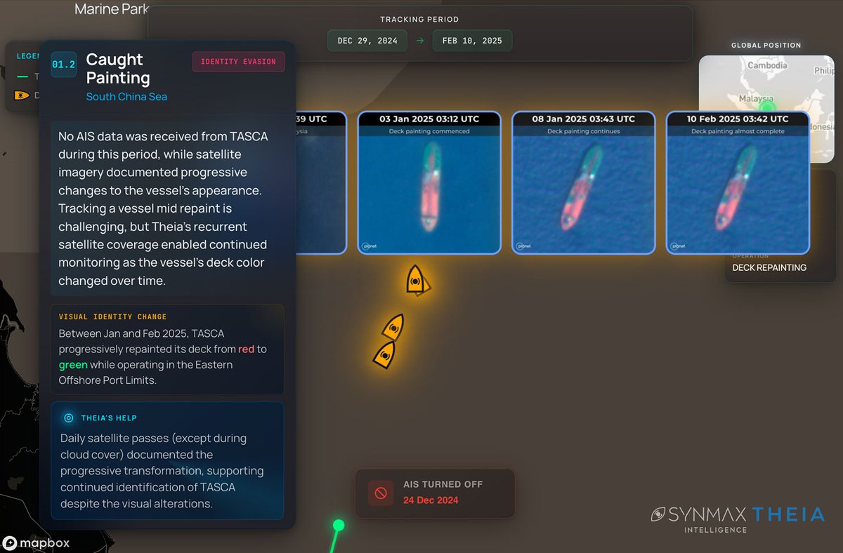
A sanctioned tanker went dark, then repainted its deck mid-ocean to avoid identification.
Theia tracked the change day by day through satellite imagery. 164K+ dark ship detections in 2025. AIS-independent, systematic, daily.
Full case in our Year in Review: https://t.co/9e9CsCrjsE
Reuters used SynMax satellite data and analysis generated through Theia in reporting on UAE crude tanker movements through the Strait of Hormuz during AIS-dark periods in April.
Theia identified dark transits, STS activity, loading operations, and downstream delivery routes using satellite imagery, vessel-pattern analysis, and AIS correlation.
When AIS goes dark, Theia keeps tracking. Read more at: https://t.co/0kMkY0Rueb
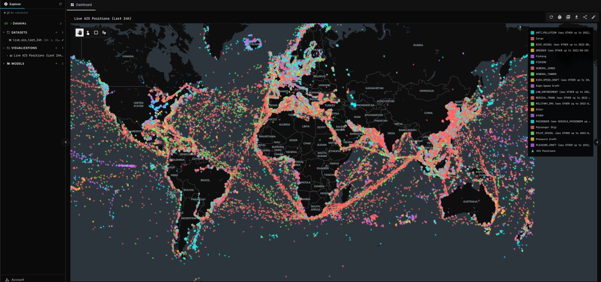
Live AIS across Theia and SynMax Agents. Every broadcasting vessel streaming in real time.
But here's what this layer doesn't show you: the vessels that turned their transponders off or are broadcasting false positions.
AIS tells you what vessels want you to see. Theia shows you what's actually happening with multi-intelligence to fill in what AIS alone will always miss.