Alright followers… here we go again. The #ElNino conversation is getting absolutely WILD, so I figured it was time for another update. This is a long one, so if you want to use Grok to know what it all means, go for it.
First, let’s get one thing straight:
Yes, #ElNino is real. Yes, it’s strengthening. And yes, the ocean anomalies are impressive. I’m not arguing any of that. What I AM pushing back on is the ridiculous amount of El Niño hype that is already happening. We’ve gone from talking about El Niño to comparing every model run to 1982, 1997 and 2015… and now the #PolarVortex has officially entered the free GFS’s imagination. 🤦♂️😂
SMH, folks. A few months ago, I spent a LOT of time talking about all of the teleconnection patterns and how they could interact with El Niño — QBO, PDO, PNA, NAO, AO, MJO, Polar Vortex, blocking, Pacific jet configuration, etc. - https://t.co/vNfh0TRWhL
I’m not getting into all of that today. We’ve talked about it enough and you can google it if you want to take a deeper dive. What I’m watching now is the trend. The tropical Pacific continues to warm, and the anomalies are becoming more impressive. But here’s the thing that keeps getting lost: El Niño tells you what the tropical Pacific is doing. It does NOT automatically tell you exactly what North America is going to do.
That’s the part people seem to forget. You can’t just look at an ENSO chart and say, “Well, this is going to be another 1982, 1997 or 2015.” There are too many other pieces moving around.
And please… for the love of God…
STOP POSTING THE 384-HOUR GFS LIKE IT’S A FORECAST. 😂
One run shows a monster storm.
The next has a ridge.
Then suddenly we have a Polar Vortex sitting over the Northeast at Day 16.
Then it disappears.
Then it comes back.
Then somebody posts it with:
“WINTER 2026-27 IS GOING TO BE EPIC!!!”
🤦♂️
Come on.
This is why I care much more about trends, persistence and how the atmosphere responds than one operational model run.
And then there’s the tropical activity…
How many times are we going to do this?
Another tropical storm forms south of Baja and immediately the internet starts screaming:
“IS THIS THE ONE THAT HITS SOCAL?!?”
😂😂😂
Folks… these systems are going to keep forming in the eastern Pacific due to the warm to hot ocean temps in that region, see the map below. That is not surprising with the current ocean temperatures and El Niño background. #polo has just formed too.
And yes, some of these storms will track east of #SoCal, while others will track west of Southern California and remain offshore. Again — and I’ll say it again — I am NOT saying there won't be showers or some residual tropical moisture coming into Southern California. There absolutely can be. We’ve already seen how a system can remain offshore and still send moisture, surf and some rainfall into the region, like on labor day weekend.. The @NWSLosAngeles was even highlighting the potential for showers and a small thunderstorm chance from Marie’s remnants while keeping the storm itself well offshore.
But there is a BIG difference between:
“Residual tropical moisture gets into #SoCal”
and
“A hurricane is making a direct hit on Los Angeles.”
Those are NOT the same thing.
And yet somehow every time a tropical system spins up south of Baja, social media goes completely insane.
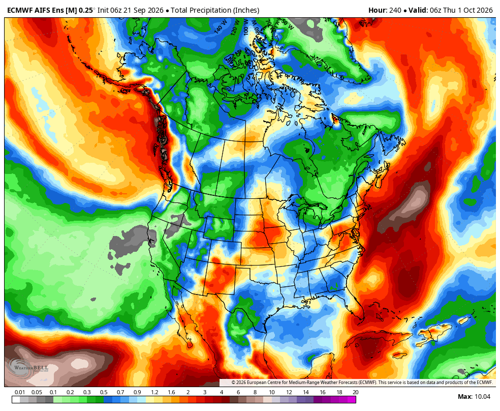
Now I’ve also posted some of those 10+ day Euro AI precipitation maps.
And yes…
I know.
They are basically weather porn this far out. 😂
I post them because they are interesting to look at — NOT because I think a precipitation bullseye 10–15 days out is going to verify exactly as shown.
It won't.
So take a look at the maps.
Look at the trends.
Look at where the models are trying to send moisture.
But PLEASE don't take a Day 10+ precipitation map and start planning your flood evacuation.
😂
That's not forecasting.
That's entertainment.
Now, what about #SoCal this fall?
This is where I have a pretty good idea of what I think we're going to see. I expect Santa Ana winds to make appearances off and on during October. Not necessarily one giant, continuous Santa Ana event — but periodic offshore wind events with warm to hot, very dry winds, followed by periods where temperatures back off and things cool down again. And honestly.....That would be pretty normal for an El Niño fall.
You can absolutely have periods of Santa Ana conditions before the pattern becomes wetter later in the season.
So don't look at a hot October and say:
“SEE! EL NIÑO IS A BUST!”
No.
The atmosphere doesn't work that way.
We can get:
Santa Ana winds
Warm/hot temperatures
Offshore flow
Dry conditions
…and then turn around and cool down again.
That back-and-forth is something I’ll be watching very closely.
Meanwhile, everyone else can keep refreshing the 18Z GFS looking for January. 😂
I'll stick with the actual trends.
Images below:
- Global SST's - Can you can see the impressive #elnino and the very warm water around Baja, but look below the equator #elnino, and you can see the #lanina forming.
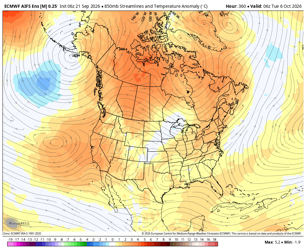
- Beginning of October will be warm in #socal. Look for santa ana winds to form.
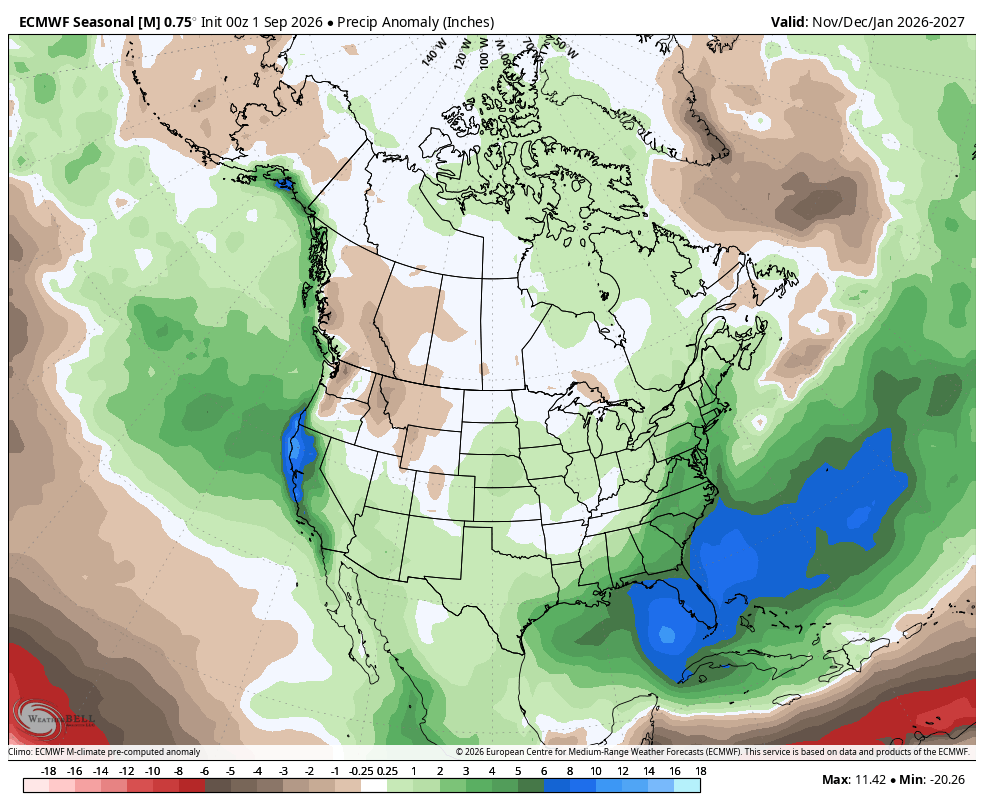
- The euro seasonal models are showing a lot of precipitation starting in November thru 2027, on the west coast. However, how cold is it going to be?? My guess is it will high elevation snow levels, which is not good.
- Euro AI model for the prep for the country and look at #socal. Meager amounts as of now, so I guess #polo is not giving us a direct hit. LOL
I will have more later this week, but again, see the images below. Not everything is what it seems, as #lanina is right on the heels of this #elnino. Don't buy into the #wxtwitter hype machine. I keep it real.......More later!
#RealWeatherForecast #Weather #ElNino #SoCal #SantaAnaWinds #PolarVortex #GFS #LongRangeWeather #Meteorology #cawx
Wow, the new Grok features in the Summer Update can do a lot more than I expected.
It truly knows every detail about the car. I see myself using this a lot while on FSD.
@KeepSafeHelp Hi, I’m having an urgent problem with my Keepsafe account and I’m not sure my in‑app support request went through (I didn’t receive any email confirmation). Thank you very much for any help or for confirming my request is queue
@Fade_Cob2 Both are low blows. End of story. That said, future opponents should test him with body shots. Even if they catch him low, they'll get a warning and take some gas out of him.
@MichaelBensonn@Canelo@terencecrawford I like Crawford by decision in a relatively boring fight. Bet we watches a ton of tape from the Mayweather fight and GGG trilogy. Times him, pot shots him and moves around strategically.
@SteveBoxman Totally agree. That said, I think the Manny that fought Cotto would have given Floyd a scare or two although the end result on paper would have been the same.
@TeamYouTube
This feature is not working on my iphone. Can you please let me know when it will be rolled out to everyone and if there are any setting I need to change/add? THANK YOU. Great feature.
@YouTubeTV@YouTubeTV This feature is not working on my iphone. Can you please let me know when it will be rolled out to everyone and if there are any setting I need to change/add? THANK YOU. Great feature.