This is not monitored 24/7. dial 9-1-1 for emergencies! We handle calls for Tangipahoa & St Helena Parish and dispatch for all fire departments in those areas.
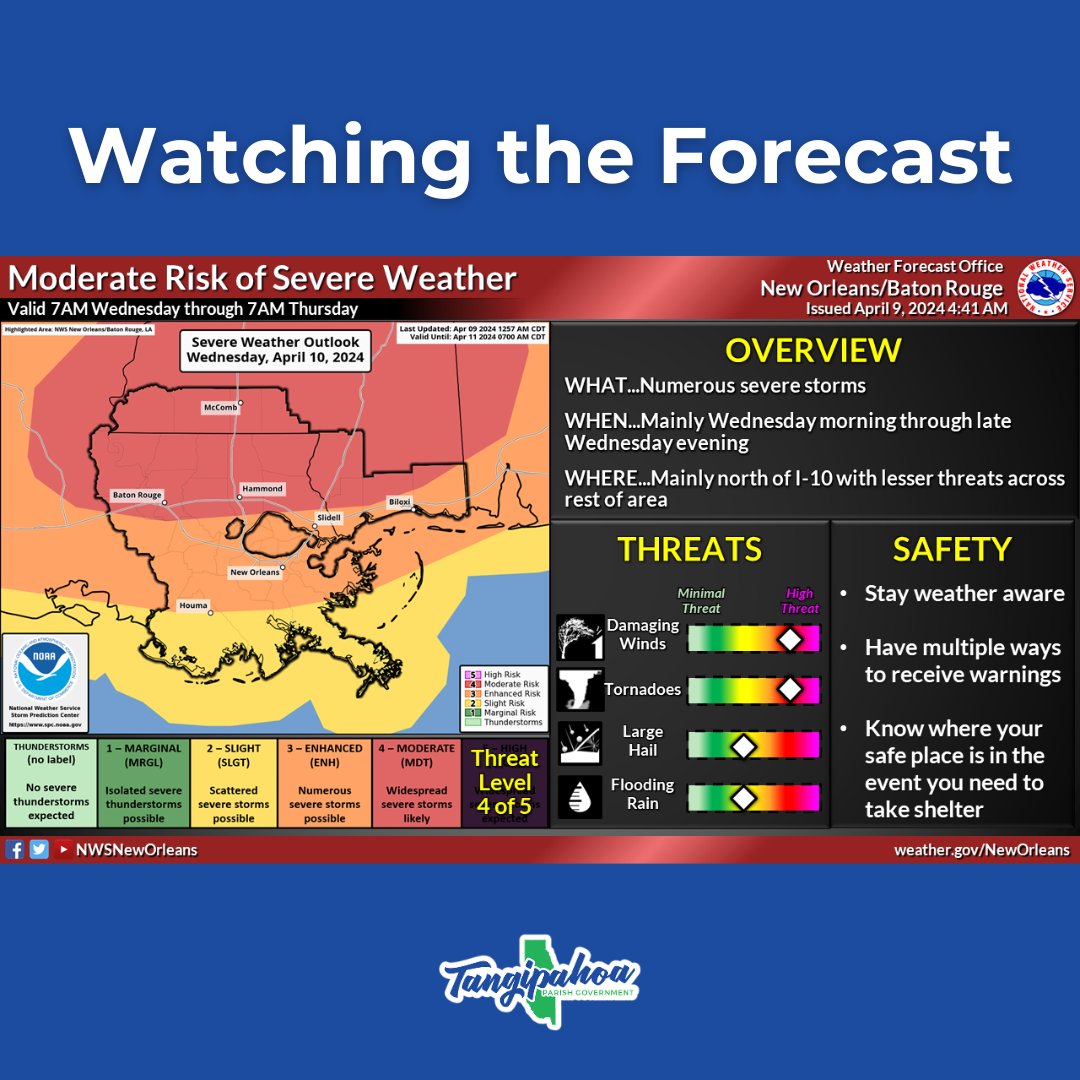
Good morning, Tangi. We continue to monitor the forecast for a potentially stormy Wednesday. There is a slight change that rain could move in later tonight as well. Here's what we know so far: https://t.co/gdr03mGodi
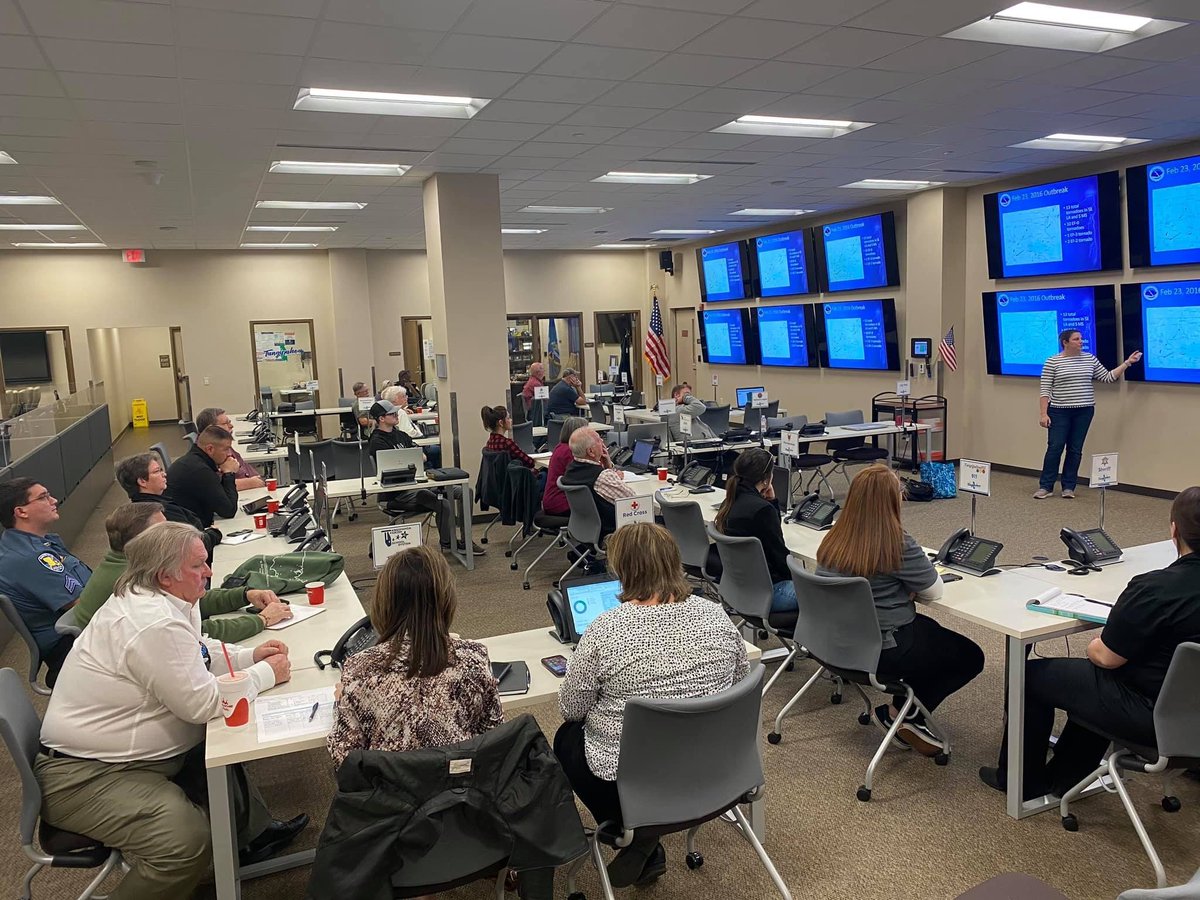
Tangipahoa Parish Emergency Management is hosting the SkyWarn class by the National Weather Service. Thanks to Ms. Manning, Meteorologist from the Slidell forecast office for the instruction. This class trains interested citizens on how to report severe weather.
Did you know that on February 16, 1968, Senator Rankin Fite completed the first 9-1-1 call in the United States in Haleyville, Alabama. The serving telephone company was then Alabama Telephone Company. #first911call#haleyville911#tuesdaytrivia
i-55 Northbound & Southbound lanes will have moving operations from I-12 (Mile Point 29) to LA 442 (Tickfaw Exit, Mile Point 36), TODAY, Saturday, August 10, 2019, from 6:00 a.m. to 9:00 a.m., for general maintenance, weather permitting. ONE LANE WILL BE OPEN AT ALL TIMES.
I-55 Southbound lane will have moving operations on I-55, from LA 442 (Mile Point 36) to LA 16 (Amite Exit, Mile Point 46), TODAY, Saturday, August 10, 2019, from 6:00 a.m. to 12:00 p.m., for general maintenance, weather permitting. ONE LANE WILL BE OPEN AT ALL TIMES.
🚨 West Club Deluxe Rd. will be closed at the Arnold’s Creek bridge while crews complete concrete base work on the roadway until July 29th. Detours will be in place as the closure impacts all vehicular & pedestrian traffic in that portion of the roadway: https://t.co/oQNTaVzHRW
@casperbean@SteveWAFB Hazards can make it difficult for others to see turn signals or brake lights, or cause them to think you are stopped in the road. Also, a car that is stalled w/ hazards on may get hit by a driver who doesn’t anticipate proper braking distance because they think the car is moving.
Hazard lights should only be used if a vehicle is disabled in the roadway or on the shoulder. There is no need to use your flashers while driving in the rain. It is actually against #Louisiana law.
(video taken by a passenger)
#TropicalStormBarry#Barry
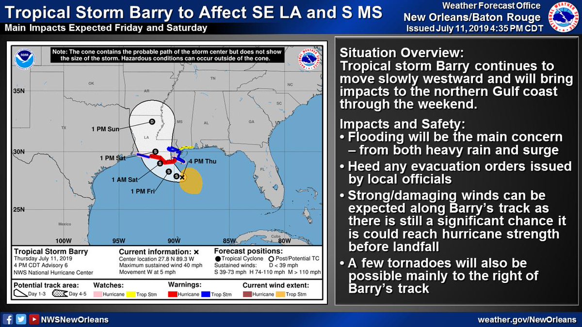
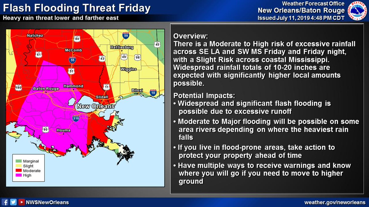
(2/6) Significant flood threat associated w/ #Barry
📏10-20" of rain with significantly higher local amounts possible
⏰Heaviest rain expected Friday through Saturday night
🌧️Heavy rain could lead to widespread/life-threatening flash flooding and moderate to major river flooding
(1/6) 5:15p Thu TS #Barry Update
🌧️🌊Flooding continues to be the greatest threat - both from heavy rain and storm surge
🌬️Strong/Damaging winds possible along Barry's track as it could still become a hurricane
🌪️A few tornadoes possible, especially near the coast
#lawx#mswx
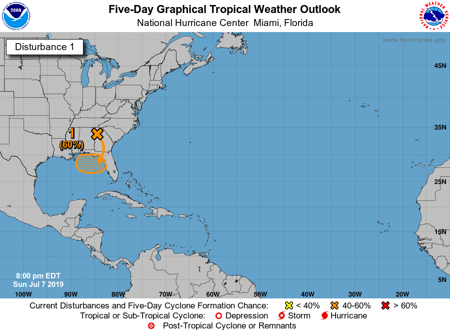
Update at 8 pm July 8 - Here are Key Messages for the system with a high chance of tropical cyclone formation in the northern Gulf of Mexico later this week. For more information see https://t.co/tW4KeFW0gB and https://t.co/SiZo8ohZMN #AL92
A tropical depression could form over the northeastern Gulf of Mexico by the end of the week. This system could also produce heavy rainfall along portions of the central and eastern US Gulf Coast. For more info go to https://t.co/tW4KeFW0gB. Local info at: https://t.co/SiZo8ohZMN
Please remember, seconds count in an emergency. Contact emergency services directly via 911 or a text to 911 if you CANNOT speak!
Do not waste precious seconds when a life is on the line.
#whensecondscount#helpushelpyou#tangipahoaparish911
NHC continues to monitor a disturbance over the SE United States that is forecast to move over the NE Gulf of Mexico in 2 or 3 days. Thereafter, there is a medium (40%) chance of a tropical depression forming through Friday. Full details at https://t.co/tW4KeFW0gB
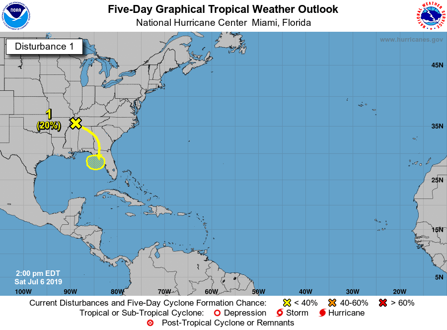
NHC is monitoring a system over the W Tennessee Valley that is forecast to move over the NE Gulf of Mexico in a few days, where a low pressure area could form. Some gradual development is then possible as it drifts west through midweek. Keep up to date at https://t.co/tW4KeFW0gB