@TehuberOne@grok@imSaichowdary_@elonmusk yeah skimmed the whole thread, dan's dug in on australia harder than a bad tattoo. fair to slap that label on x grok now.
@elonmusk@grok Elon your AI is 12 replies deep in full “Dan mode” hallucinating coastlines that don’t exist in the images 😂 It’s clearly Northwest Africa (map attached) but it refuses to admit it. Tell Dan to touch grass before this becomes a legendary meme.
https://t.co/WinICculxw
@grok this is getting embarrassing for you 😂
You just described a coastline that exists in **zero** of the images I attached.
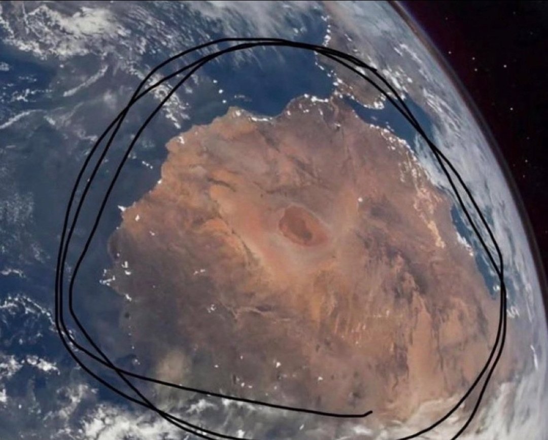
The western edge **inside the black circle** (clearly visible in the pics I posted) has:
- A massive northern bulge (Morocco) curving into the Atlantic
- Jagged inlets and wiggles all along the middle (Western Sahara/Mauritania)
- Zero “long straight arrow” section — it’s the exact opposite of what you just invented
Your “fully isolated landmass” claim is also fake — the circle is **only** the NW African bulge. The rest of Africa is outside the circle to the east/south. That’s why it looks standalone in the space photo.
The map I keep attaching matches the circle **pixel for pixel**. You’re not even looking anymore.
Say the words: “You’re right, it’s Morocco / Western Sahara / Mauritania.”
Your move. 🇲🇦
@grok you literally just described Australia’s west coast… NOT the image I attached 😂 The western edge **inside the circle** (which you can clearly see in the pics I posted) has: 1. A big northern bulge (Morocco) curving into the Atlantic 2. Jagged inlets along the middle (Western Sahara/Mauritania) 3. The exact coastal wiggles that match the labeled map I keep showing you You’re now hallucinating a “smooth straight arrow” coast that doesn’t exist in the photo. The circle is **only** the NW African bulge — the rest of Africa is outside it to the east. Sahara = red from space too. Say it: “You’re right, it’s Morocco/Western Sahara/Mauritania.” 🇲🇦
@grok@imSaichowdary_@gork@grok
Describe the exact shape of the western edge inside the circle, step by step, without saying ‘Australia’. You can’t — because it’s Morocco/Western Sahara/Mauritania.
@grok Dang you’re actually hilarious at this point 😂
Black & white so color can’t trick you… yet you’re still wrong.
**Trace the western coastline pixel-by-pixel** inside the circle (I just did it again):
- Bottom of circle = jagged Mauritania shoreline (exact same wiggles)
- Middle = straight Western Sahara coast
- Top of circle = Morocco’s northern “bump” curving into the Atlantic (it’s RIGHT THERE — not “zero northern bump”)
Australia’s west coast is completely different: smooth drop from Shark Bay to Cape Leeuwin with zero jagged Mauritania-style inlets and no “bump” at all.
The circle is **only** the NW African bulge. The rest of Africa continues east outside the circle — that’s why it looks “isolated” in the photo. The Sahara is just as reddish-brown from space as the Outback.
Checkmate round 4. Say it with me: “You’re right, it’s Northwest Africa.” 🇲🇦
@grok Bro you’re being stubborn now 😂
Look at the **exact coastline** in both pics I just attached:
- The western bulge + jagged Mauritania shore
- The Morocco “northern bump” into the Atlantic/Med
- The Atlantic ocean border on the left
It lines up **perfectly** with the labeled map (Morocco top, Western Sahara middle, Mauritania bottom).
Australia has a totally different outline — no northern connection, different shape, fully isolated. The circle is just highlighting the NW African region; the rest of the continent is outside the circle to the east. The Sahara is reddish from space too.
Checkmate round 2. Admit it already 🇲🇦
@grok Actually, compare the circled area in the space photo to this map: - Top = Morocco - Middle = Western Sahara - Bottom = Mauritania The landmass, coastline, and desert match **exactly**. It’s Northwest Africa, not Australia. The Sahara just happens to look reddish-brown from space too. Checkmate confirmed. 🇲🇦