BALTIMORE BEAUTY WEDNESDAY: These are the type of days we dream of in middle of the dog days of summer. Gorgeous! Comfortably cool morning. Comfortably warm this afternoon. Great for all outdoor activities. Sun glare and very high ragweed pollen your biggest problems. Enjoy!
GOOD TUESDAY MORNING MARYLAND! Kids & adults have shorter workweek ahead. For kids attending their first day of school in Carroll, Caroline, Harford, & Cecil counties we've got a beauty of a day. Patchy AM fog then gorgeous for everyone. Jacket early this AM to short-sleeves @WJZ
REFRESHINGLY COOL @ BEACHES: A northeast wind has ramped up and that means we're dealing with a MODERATE risk of rip currents at the ocean beaches. Water and air temperatures almost match. Tomorrow the rip current risk is HIGH if you're extending your stay. Listen to lifeguards!
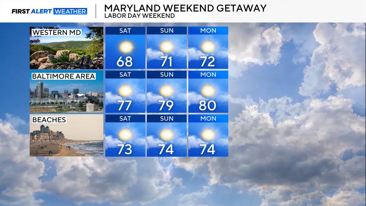
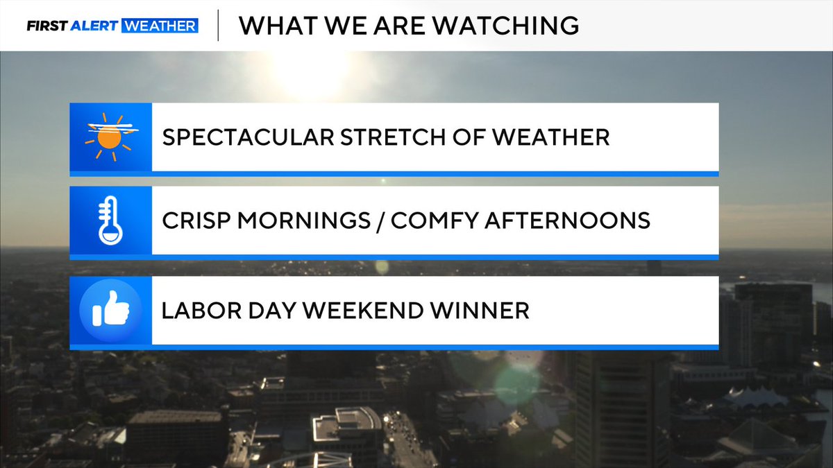
LOVELY LABOR DAY WEEKEND FOR MARYLAND: It's a rarity these summer holiday weekends are picture perfect all three days. Well we picked a four-leaf clover this year. Gorgeous! While it may not be the warmest, still decent for beaches. Ideal for hiking, state parks, grilling! Enjoy!
GOOD MORNING! Great news on this terrific Tuesday. Weather looks FANTASTIC! Crisp & comfy this morning. Sunny & pleasantly warm this afternoon with highs near 80°. Humidity levels stay low. We keep this winning stretch right through Labor Day Weekend. Slight shower chance Friday
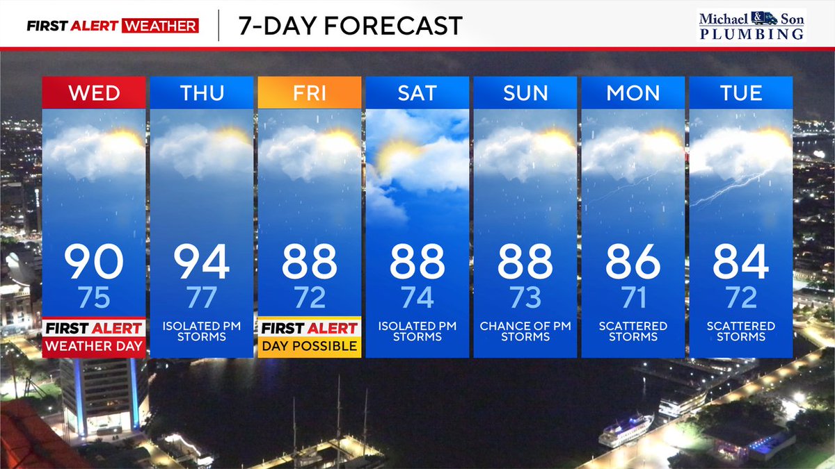
First Alert Weather Day for a chance of scattered PM storms. Heat index could reach as high as 103°. Storms mainly west of 95 corridor fire up after 2 PM. Keep an eye to the sky & please do not try crossing flooded roads
Hot and humid with a chance of afternoon storms. Monday could be more active and possibly an Alert Day... we'll keep you posted, #wjz#firstalertweather
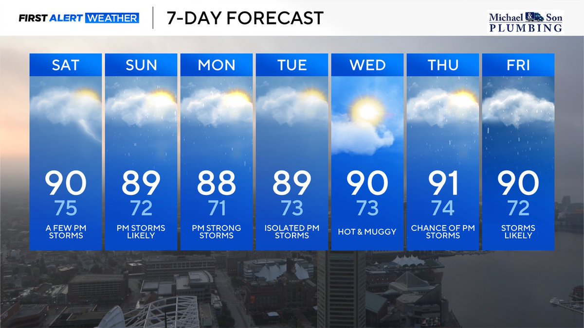
Dog days of Summer are in full force. Hot and humid for the next week... each with a chance of t-storms. Stay cool, hydrated and keep an eye to the skies during the afternoons. #wjz#firstalertweather
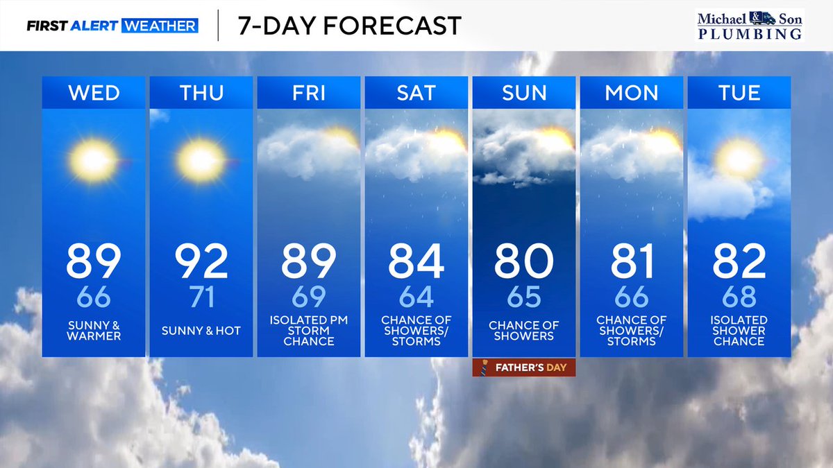
*Air Quality Alert for today. Temps reach the low 90s. Rain chances Friday - Monday. Father's Day is not a washout but have a back-up plan for dad's outside plans. #wjz#firstalertweather
Welcome to a taste of early Summer. High temperatures hit upper 80s today. Thursday may be our hottest day of the year so far. Rain chances return Friday and make for a damp Father's Day weekend. #wjz#firstalertweather
Morning showers make for a damp commute. Temperatures are mild and we dry out this afternoon. Sun returns Wednesday PM. We stay warm through weekend with a chance of showers each of the next several days. #wjz#firstalertweather
Very mild week ahead with highs in the mid to upper 70s and lows in the 50s. Next chance of showers is Friday into Saturday. Enjoy a pleasant Spring stretch. #wjz#firstalertweather
Gusty and mild today with a Wind Advisory in effect from 10 AM to 8 PM. Temps in the mid 60s with gusts as high as 41 mph. Otherwise, becoming mostly sunny and breezy. Rest of the week is pleasant with showers arriving Friday into Saturday. #wjz#firstalertweather
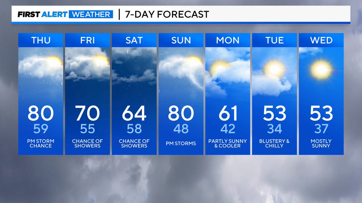
Partly sunny and mild Monday. Keeping an eye out for strong thunderstorms late tonight. Rest of the week is relatively comfortable and calm with our next chances for storms Tuesday & Saturday. #wjz#firstalertweather
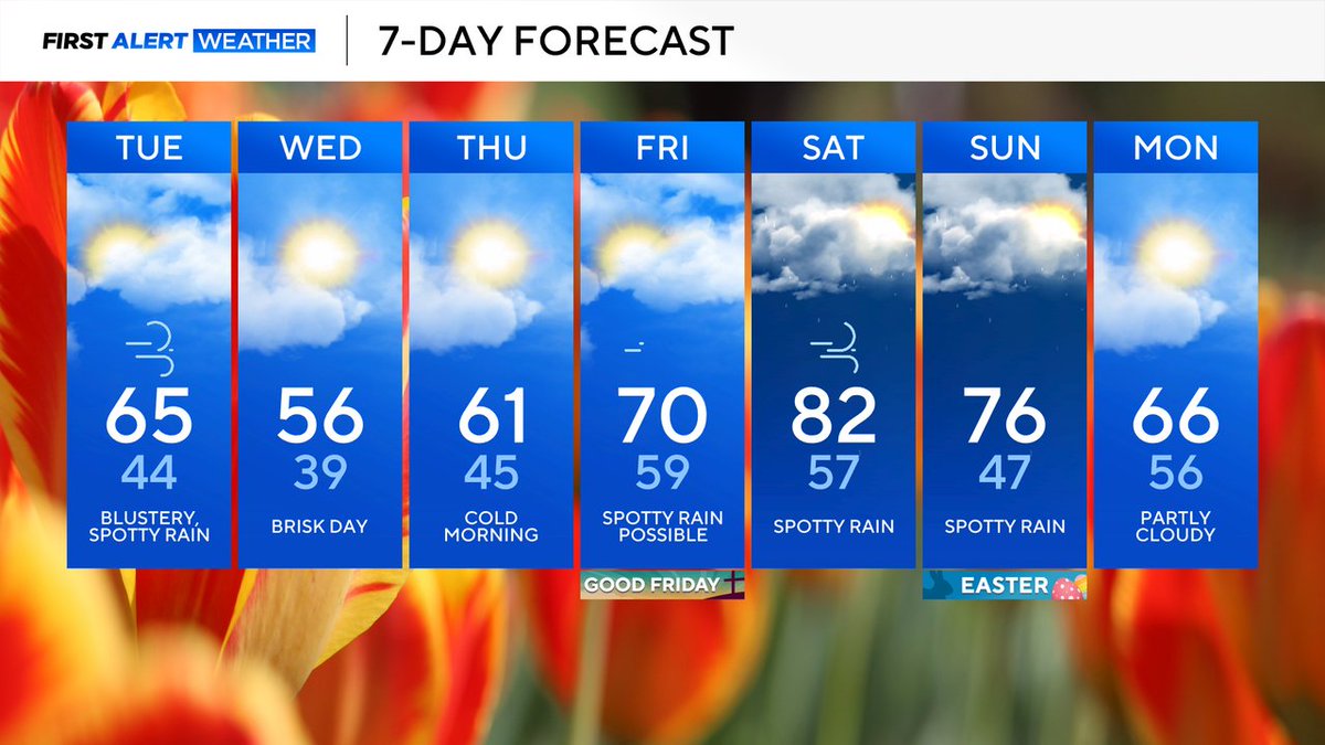
Cool and damp Monday. Turning sunny and chilly for next few days. Showers return for weeks' end. Plan for a fickle first full week of April. #wjz#firstalertweather
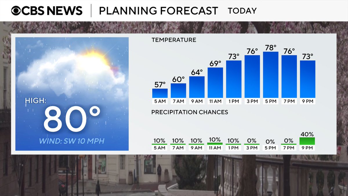
Unsettled weather through the weekend. Expect a chance of showers and gusty thunderstorms mainly after 5PM today. Otherwise, cloudy and warm with a high near 80°. Temp roller coaster for next few days. #wjz#firstalertweather
Gray and very warm with a chance of late day thunderstorms. Highs near 80° with storms most likely after 5pm. Storms could bring gusty winds and hail. Stay tuned. #wjz#firstalertweather