Tonight will feature lows mainly in the mid 50s to lower 60s. Parts of northern Oneida County will likely see lows in the lower 50s or even some upper 40s. #NYwx#PAwx
Mostly sunny + warm today; heat & humidity build more on Tuesday; peaking at dangerous levels Wed-Thu-Fri. Make a plan now for how you will keep cool! Also: Isolated to scattered thunderstorms Tuesday, a few of which could be strong to severe. #pawx#nywx#heatwave
Today will be the "coolest" day over the course of the next week, with near-normal temperatures. Heat builds into the area the beginning of next week. Most of the area will be mostly sunny today, but clouds and a few showers will be present across parts of NE PA. #NYwx#PAwx
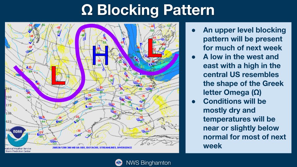
An Omega blocking pattern will be over the country for most of the next week. For our region, conditions will be mostly dry and temperatures will be near or slightly below normal for most of the week.
Good afternoon! Rain has overspread the area and this will continue through the afternoon. A bit of a lull in the rain is possible this evening, before more showers fill back in after midnight tonight. #NYwx#PAwx
Very happy to say we finally have a blooming lilac tree in our back yard and it smells great! Hard frosts have killed this tree the last several years. It survived some frosty nights this spring to bloom 😎
Tornado Warning for northern Oswego and southern Jefferson counties until 5:45pm. Chief Meteorologist @JimTeskeNC9 has the latest right now on @NewsChannel9
Today will feature more sun than yesterday, but still scattered to broken fair weather clouds ⛅️ into the afternoon hours. 10 AM temps are in the 40s, and will rise into the 50s 🌡️ for highs this afternoon. NW winds will be a bit breezy, between 15-25 mph. Enjoy🙂 #nywx#pawx
Good morning and welcome to May! It will feel more like early to mid April, rather than the first day of May, but it will be mostly sunny this morning. Clouds will increase this afternoon as another round of showers moves into the area from the west. #NYwx#PAwx
Mild & dry today (Highs 58-65°). 🌥️ Rain arrives late tonight, continuing through Saturday. 🌧️ a little wet snow may mix in for high elevations Sat night. ☀️ Sun returns Monday! #NYWX#PAWX
Latest Update: Still expecting storms to begin firing up around 3-5PM this afternoon across the NW Finger Lakes region, moving east along I-90 into Syracuse metro area & Oneida County as well. Isolated damaging winds, hail & even a tornado will be possible. Stay weather aware!