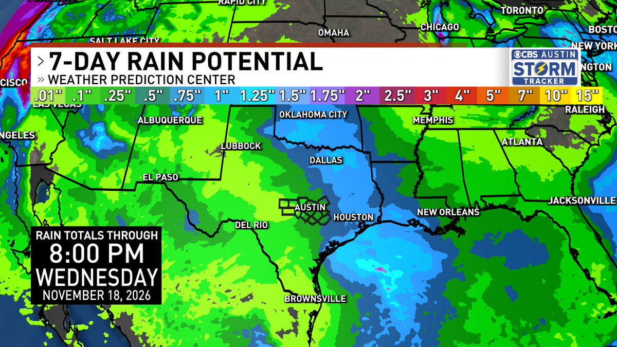
The Weather Prediction Center has the heaviest rain in our eastern counties points east with a weekend storm system on the way. It's actually two separate disturbances, one Saturday and one Sunday, that will bring us the rain. Sunday's is more potent. #atx#atxwx#txwx
Expect a cool and rainy weekend. Heaviest rains will be to southwest of our area with flooding possible in the Rio Grande Valley. Expectations of about 1/2" to 1" for us.
Cooler temperatures along with widespread rain are expected this evening through Monday. Locally heavy rainfall could lead to some isolated flooding, but rainfall rates should remain low enough to limit overall flooding potential.
Central Texas is currently experiencing Level 1 to 2 drought conditions, but the wetter-than-normal winter outlook could bring some much-needed rain and help ease the drought. #txwx
Breezy conditions with cooler temps today. Highs in the mid 70s. This weekend shaping up to be even cooler with increasing rain chances. Heaviest rains currently forecast to stay to our south.
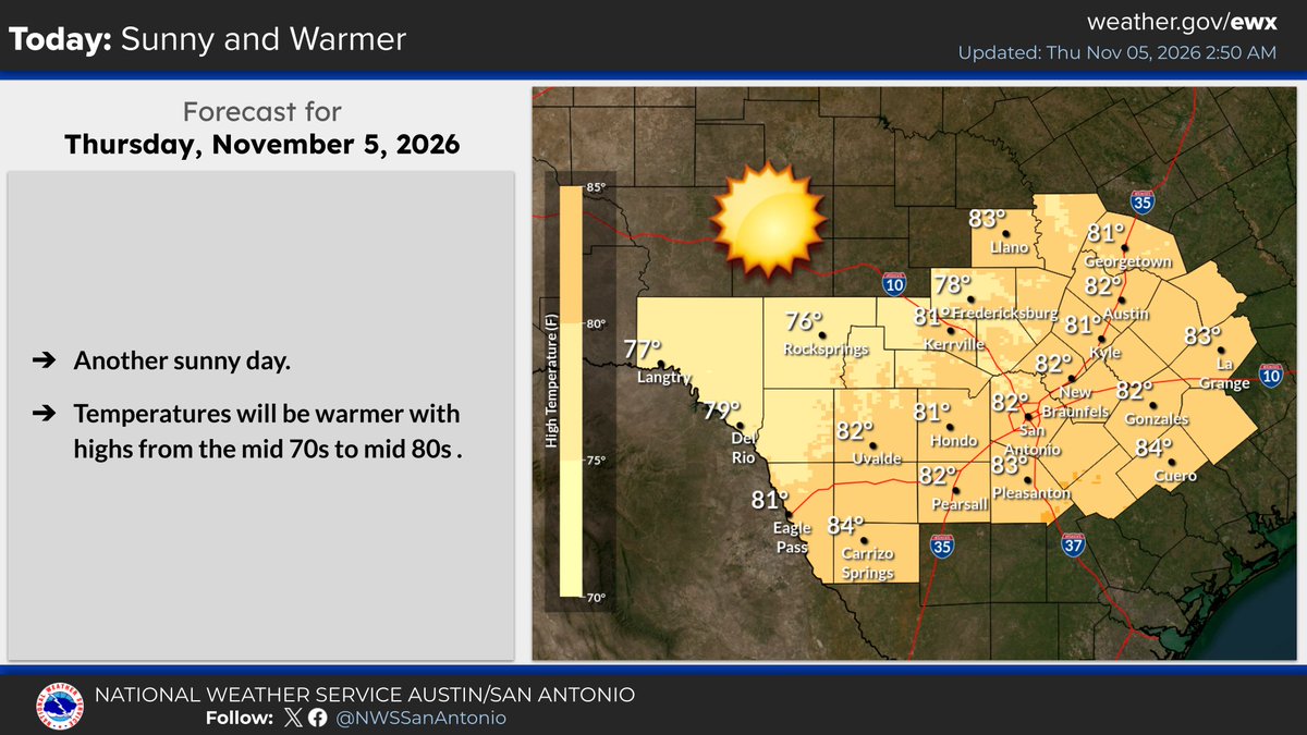
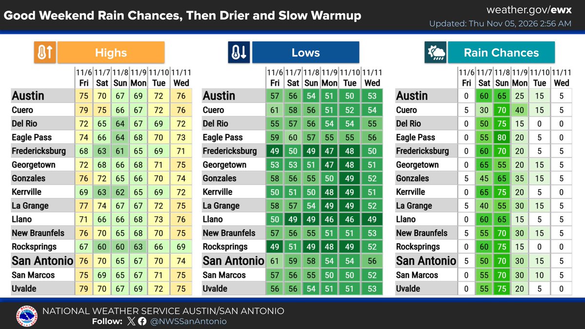
Today will be and sunny day. Temps will be warmer with highs mid 70s to mid 80s. Rain chances over the weekend have increased and widespread rain likely. Temps will be cooler over the weekend and then warm slowly into next week. Mainly dry weather for the first part of next week.
Not the final tally just yet, but Austin has at least seen its biggest one-day soaking since mid-JUNE.
1-2" totals stretch from Pflugerville back towards the northern Hill Country. Not a single severe thunderstorm report along the way #atxwx#txwx
Storms have weakened some as they approach I-35. Still have frequent lightning and some gusty winds to around 35 MPH, and maybe a few spots of small hail. Biggest impacts will be along the northern edge of the county into Williamson County.
@Portastorm Not too bad just a little south of you here in P'ville. Kinda surprised Tricia hasn't posted something. Storms were a little more potent out here way.
Radar update: strong thunderstorms now moving across western parts of the county. Some high winds to 50 MPH and hail to 1/2" are possible in these storms as they move through.
A Special Weather Statement has been issued that includes portions of western Travis County. Winds of 50 MPH and half inch hail are possible in this area.
Latest model runs show the frontal boundary passing our area somewhere around 3 AM overnight tonight. Model shows that the line may include some thunderstorms as it passes. Main threat from these storms will be high winds.
Level 1 risk (out of 5) for severe storms for Travis County for tonight. The primary threat for us will be some high winds with the storms as the front passes through.
A line of showers & storms will move across the area overnight into Tuesday AM. Some storms could be strong to severe with a level 2 of 5 risk over parts of the Edwards Plateau & Hill County. Damaging wind gusts & large hail are the most likely threats. Stay weather aware! #txwx