OVER THE CARIBBEAN - Inside the eye of Category 5 Hurricane #Beryl!
NOAA WP-3D Orion #NOAA43 “Miss Piggy” continues operations into Hurricane #Beryl to collect data for hurricane forecasting and research.
Visit https://t.co/0W0v11Anw1 for the latest forecast and advisories. #FlyNOAA
📸: Lt. Cmdr. Kevin Doremus, NOAA Corps
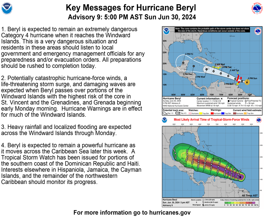
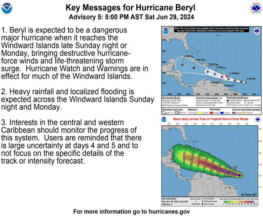
Key Messages for Hurricane #Beryl at 5pm AST June 30th:
Extremely dangerous Category 4 hurricane approaching Windward Islands, with highest risk of the core going over St. Vincent & the Grenadines, and Grenada early Monday Morning. All preparations should be rushed to completion today.
https://t.co/iWN8HtCakF
Hurricane #Beryl Advisory 7: Beryl Continuing to Rapidly Intensify. Forecast to Bring Life-Threatening Winds and Storm Surge to the Windward Islands as an Extremely Dangerous Hurricane. https://t.co/tW4KeGe9uJ
5PM AST 6/29: #Beryl is now a hurricane and is forecast to intensify quickly. Expected to bring life-threatening winds and storm sure to the Windward Islands as a major hurricane. A hurricane warning is now in effect for the island of Barbados. For the latest https://t.co/Wq6ZtKgfeH
11pm AST June 28th -- TD2 has become Tropical Storm #Beryl. Here are the latest key messages & Hurricane and Tropical Storm Watches will likely be
required for portions of the Lesser Antilles early Saturday.
https://t.co/RX183Ip5Fx
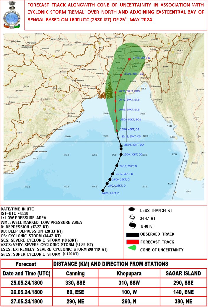
SCS Remal over North BoB is about 220km SSW of Khepupara, 210km SE of Sagar Islands. Max wind speed of 95-105 kmph is over cyclone centre. Likely to move northwards intensify and cross Bangladesh and adj WB coasts midnight of today, the as SCS with max wind speed of 110-120 kmph.
The CS "Remal" over North & adjoining EC BoB about 300km S SE of Sagar Islands(WB) 310km S SW of Khepupara(Bangladesh). To intensify into a severe cyclonic storm by 26 morning and cross between Bangladesh and adjoining WB coasts around 26 midnight as SCS.
Heavy Rainfall Warning No. 5 #NCR_PRSD
Weather System: Tropical Storm AGHON
Issued at: 5:00 AM, 26 May 2024(Sunday)
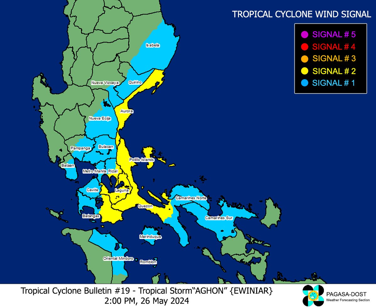
ORANGE WARNING LEVEL: Quezon.
ASSOCIATED HAZARD: FLOODING is still THREATENING.
YELLOW WARNING LEVEL: Bulacan, Rizal, Metro Manila and Laguna.
ASSOCIATED HAZARD: FLOODING in flood-prone areas.
Meanwhile, expect light to moderate rains over Tarlac and Zambales within the next 3 hours.
Light to moderate with occasional heavy rains affecting Nueva Ecija, Pampanga, Bataan, Cavite and Batangas which may persist within 3 hours.
The public and the Disaster Risk Reduction and Management Offices concerned are advised to MONITOR the weather condition and watch for the next warning to be issued at 8:00 AM today.
For more information and queries, please call telephone numbers 8927-1335 and 8927-2877 or log on to https://t.co/59mTpZJq1n.
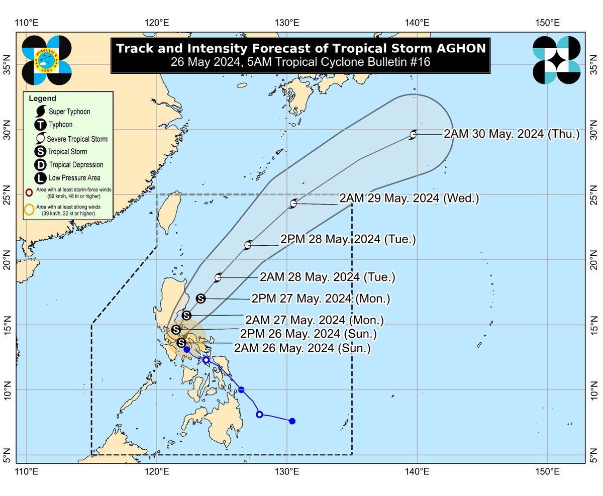
TROPICAL CYCLONE BULLETIN NR. 16
Tropical Storm #AghonPH
Issued at 5:00 AM, 26 May 2024
Valid for broadcast until the next bulletin at 8:00 AM today.
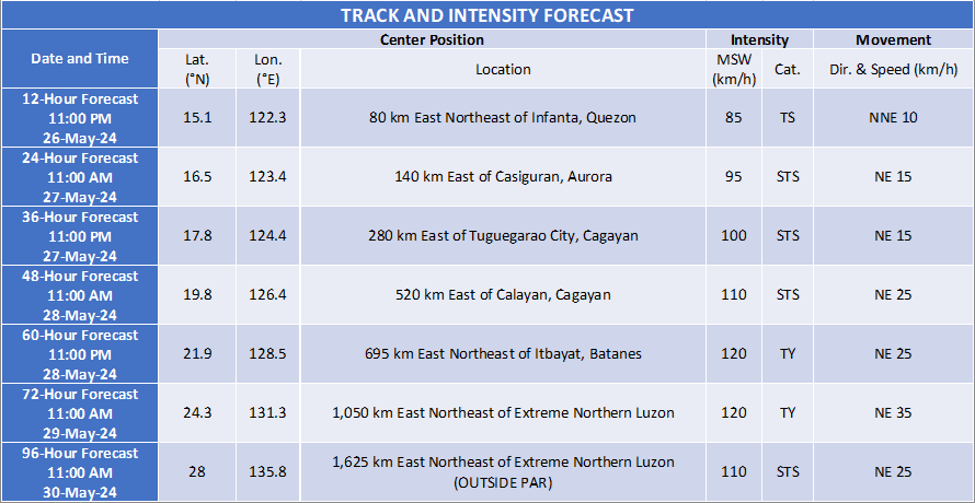
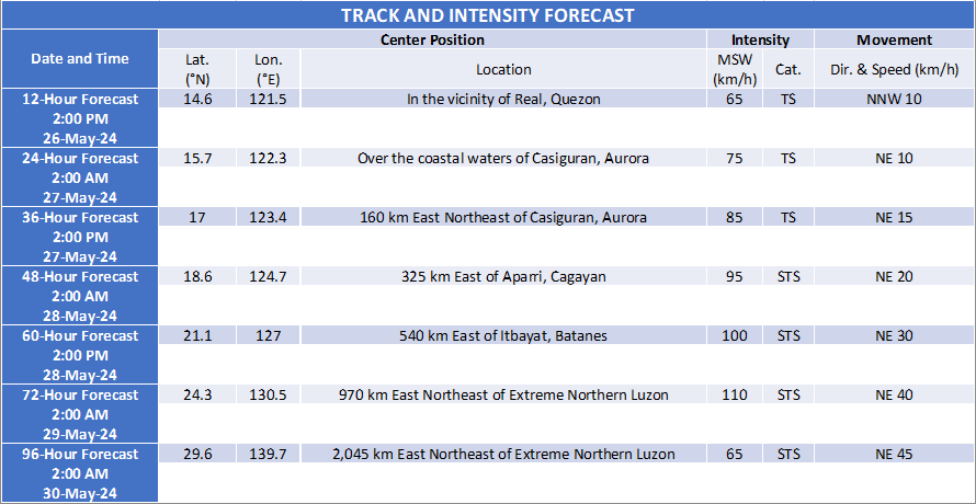
“AGHON” INTENSIFIES INTO A TROPICAL STORM OVER TAYABAS BAY.
2 Systems being monitored
Cyclonic Storm #Remal - Bay of Bengal heading toward the Delta, Bangladesh
Tropical Storm #Aghon PH over Mauban Quezon & NW waters of Lopez Bay, Philippines (JMA have it still @ TD)
Both carrying 65kph Winds
Rainfall for both approx 250mm per 24hrs
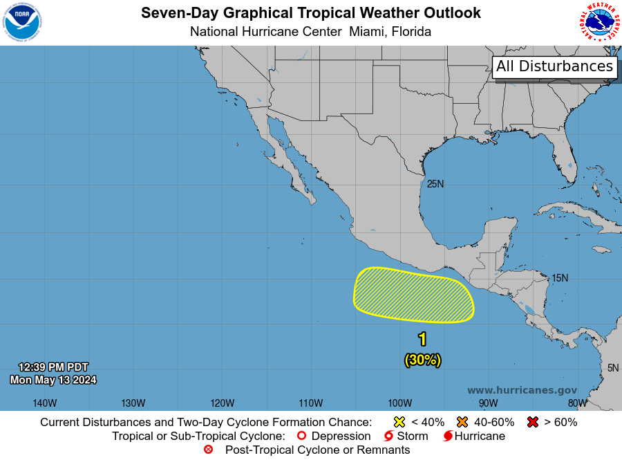
12:20 PDT May 13 -- A Special Tropical Weather Outlook has been issued for an area of low pressure expected to form later this week south of the coast of Mexico. This system currently has a low chance (🟡30%) of development through early next week.
https://t.co/iYIpekuSTw
STS #Hidaya passing just N of Mafia I toward Dar es Salaam Tanzania
Red Warning
10min winds 110kph
1min winds 100kph
Pressure 985 hPa
Moving W about 13kph
Rain Accum approx 300mm over 48hrs
Waves possible 4-6m
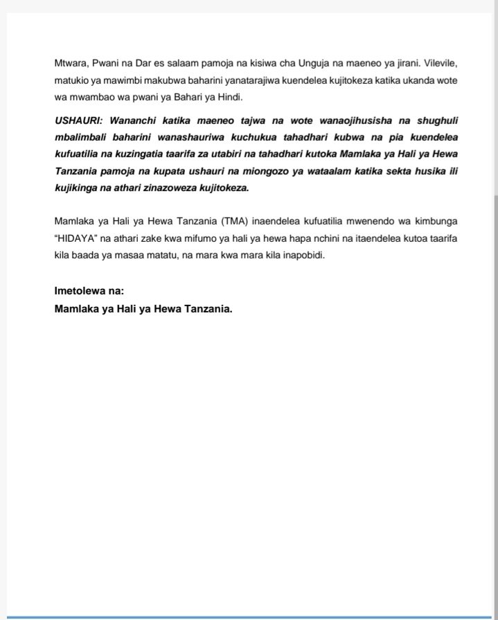
Dar es Salaam, 04 Mei 2024 saa 12:00 Asubuhi:
Mamlaka ya Hali ya Hewa Tanzania (TMA) inaendelea kutoa taarifa ya mwenendo wa kimbunga “HIDAYA” kilichopo karibu na maeneo ya pwani ya nchi yetu.
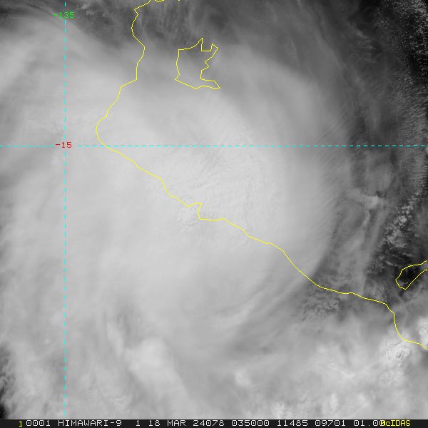
🌀Tropical Cyclone Paul formed in the northeast Coral Sea early Thursday morning. Small systems can develop quickly. TC Paul may reach Category 3 (severe tropical cyclone) tonight, but should weaken rapidly on Friday. No cyclone impacts on #Qld. Details: https://t.co/YTkwbdYNGp
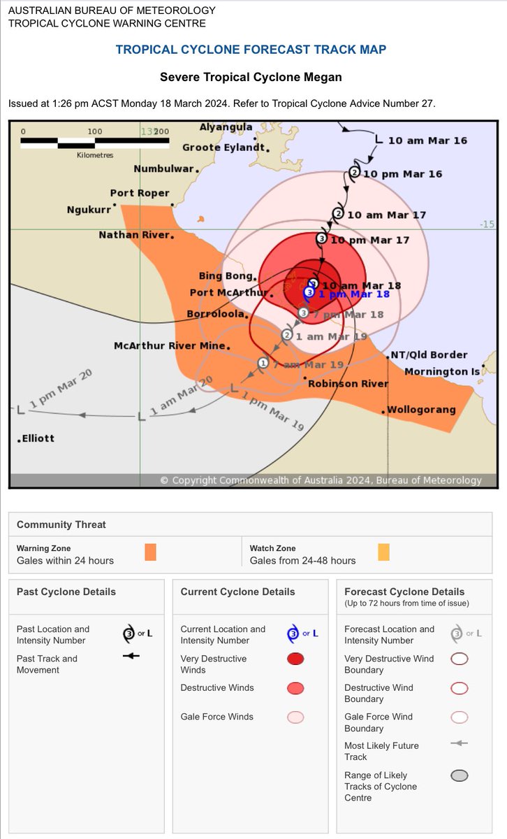
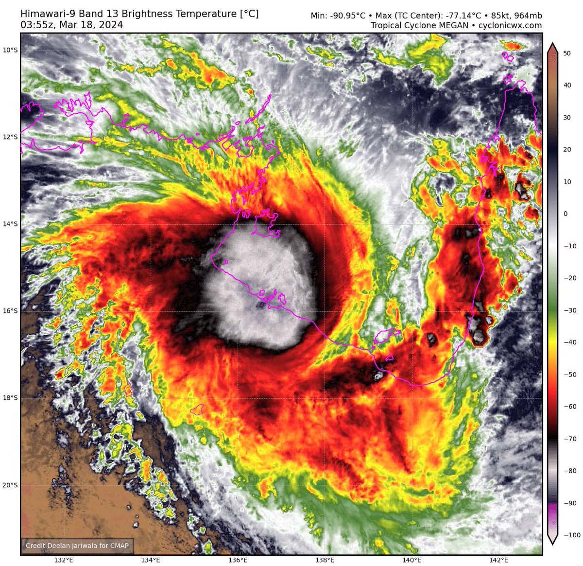
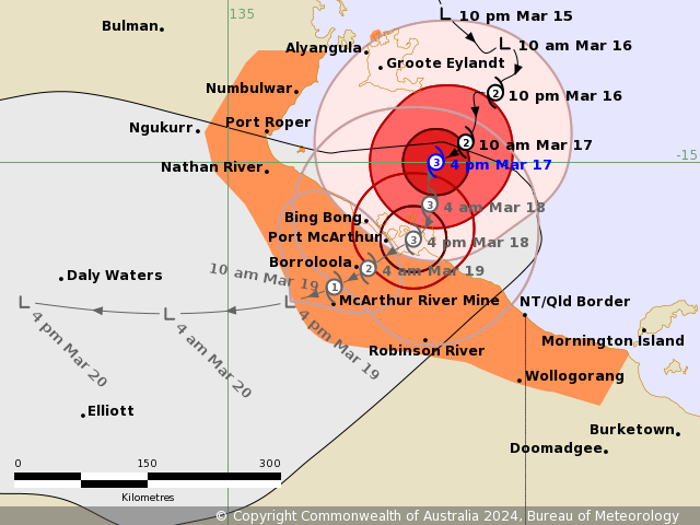
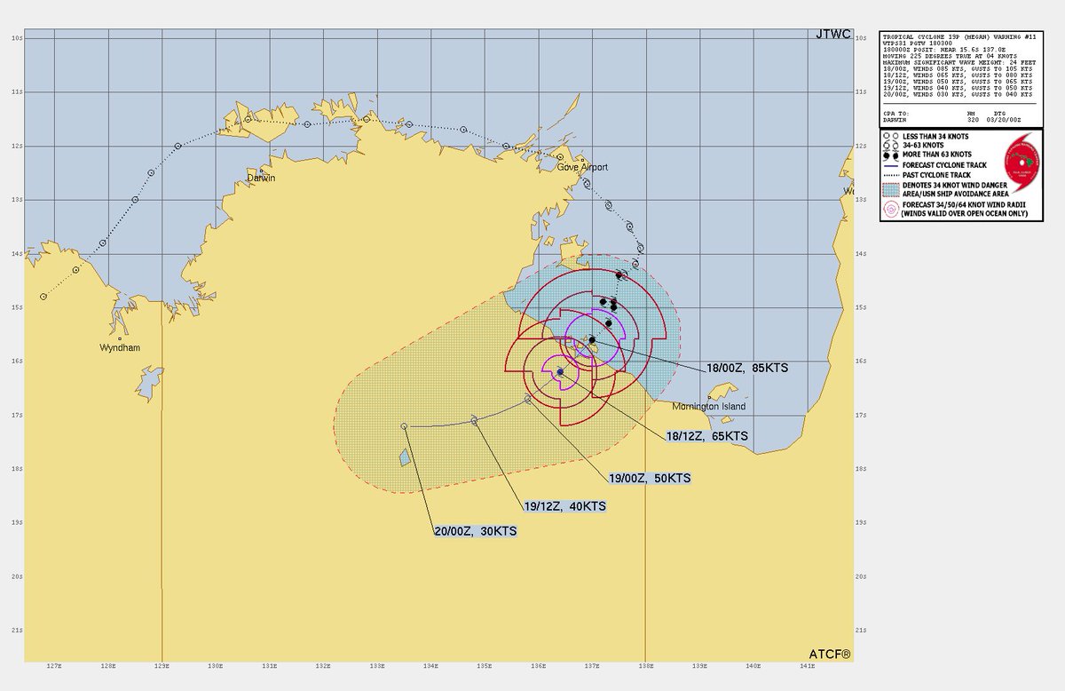
STC #Megan Cat 3 making landfall over Pellew Islands & McArthur R Delta SW Gulf of Carpentaria, gusts nearing 200kph having winds from 140-155kph, Centre Island 121mm since 9am this morning & 223mm past 24hrs to 9am
⛈️ Thunderstorm forecast Monday (18/3). Heavy rainfall & damaging winds possible about the southern Gulf coast. Heavy rainfall possible about northeast tropical coast north of Cardwell. Thunderstorms also possible in the southeast and southern interior. https://t.co/M5VPKkuViE
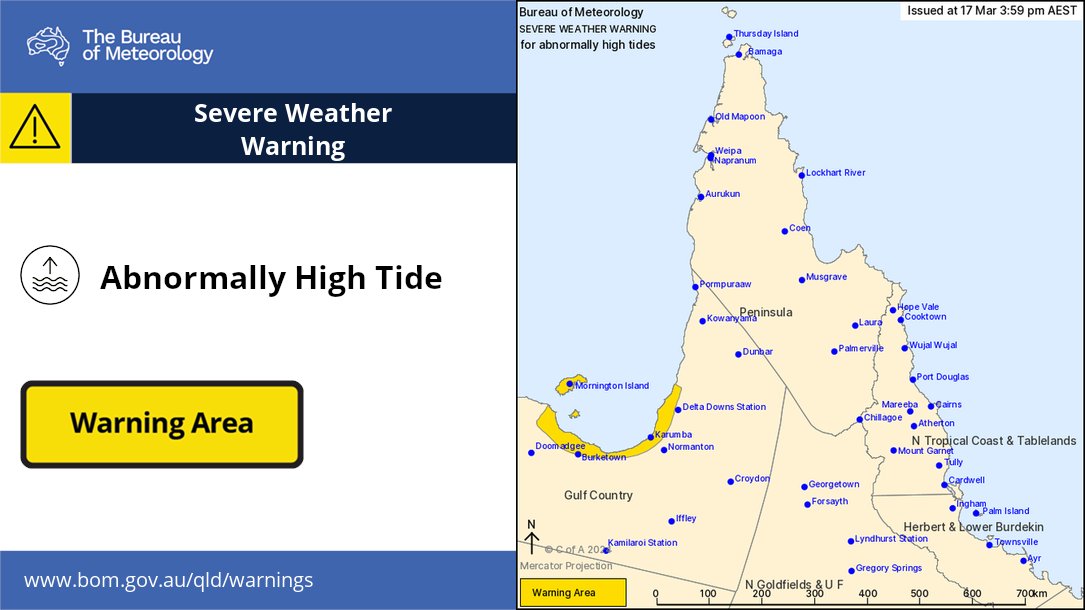
⚠️🌊#QLD Severe Weather Warning for abnormally high tides in the Gulf Country due to #Cyclone#Megan. Water levels on the high tide are likely to exceed highest tide of the year. Area includes Mornington Island, Burketown and Karumba. Check details https://t.co/eJf80G3G0r
⚠️🌀 Severe Tropical #Cyclone#Megan warning zone for next 24 hours: Alyangula (Groote Eylandt) in NT to Mornington Island in #Qld (not including Mornington Island), extending inland to Borroloola, McArthur River Mine, and Robinson River. Details at https://t.co/fxn3NUmzLD
TC #Megan Gulf of Carpentaria continues quick intensification making probable Cat 3 landfall to the Pellew Islands/McArthur R mouth from Monday evening, dangerous & high storm tide expected, rainfall past 48hrs Groote Eylandt Airport nearing 700mm