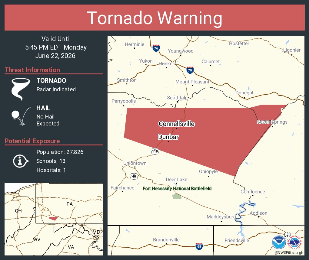
Uniontown Emergency Management Agency. In an emergency call 911. Dedicated to sharing threat,prepredness & general safety information to greater Uniontown Pa.
Heads up! Severe thunderstorm potential today mainly between 2 PM and 8PM, especially south and east of Pittsburgh. Damaging wind gusts are the primary concern, although a tornado or two may be seen as well.
Along with the severe threat, here is one model suite's view of the probability of 1" or more of rain through 8 PM. Isolated 2-3" totals can't be ruled out south of Pittsburgh, and if confidence increases, a Flood Watch may be needed later.
A widespread, soaking rain is expected Sun night-Mon. There is a high probability of at least 1" between 8 PM Sun and 8 PM Mon, with decent chances of over 2". Currently, the threat of widespread flooding is low, but a Flood Watch may be needed if the risk increases.
Good morning! Today will be mainly dry but an isolated afternoon shower is possible. Better shot at scattered showers/storms Saturday afternoon. Sunday will be dry but more widespread rain arrives that night. Temps will be near to below normal. Enjoy!
#PLANNED BRIDGE CLOSURE#
THE BRIDGE ON N GALLATIN AVE IN THE CITY BETWEEN E PENN & LINCOLN STS WILL BE CLOSED FOR REPLACEMENT JUNE 22 TO EXPECTED MID-SEPTEMBER. DETOURS ARE POSTED BELOW.
Here are the latest severe weather outlooks for tonight and Thursday. In addition, wind gusts from 35 to 45 mph are expected even outside of any thunderstorms on Thursday.
Dry weather will continue today. Scattered showers are expected tonight, with a potential for severe storms late Wednesday into early Thursday. Additional severe storms are possible by mid day Thursday.
High temperatures will be limited to the mid-60s through low-70s in the wake of a cold front, which is about 10 degrees cooler than the seasonal average.
THE NATIONAL WEATHER SERVICE HAS CANCELLED SEVERE THUNDERSTORM
WATCH 333 FOR THE FOLLOWING AREAS
FAYETTE
THIS INCLUDES THE CITIES OF CONNELLSVILLE, FAIRMONT, MASONTOWN,
MORGANTOWN, AND UNIONTOWN.