(1 of 2) We have plenty of historical Category 5 landfall candidates for the Atlantic basin. Storms like 1825 Santa Ana, 1831 Barbados, 1838 Bahamas, and et cetera. Yet out of all of these, one has always stood out. The 1780 Great hurricane.
The environmental wind damage reported from this cyclone was unbelievable. While storms like Dorian 2019 had some slight debarking here and there, what was documented in 1780 was widespread and seemingly unseen until Melissa. At least for the Atlantic.
It's hard to compare 1780 to storms like Haiyan 2013. Their environments differ vastly. Though nonetheless, it's been surreal actually tracking an event that compares to the 1780 storm.
My apologies. That was a bug. Since that storm in question came from another basin, but passed the polygon check, it skipped the ENSO filter. This should be fixed now!
You're correct about 1949 not being an El Niño year. Sources for the ENSO (and other) data is provided here: https://t.co/W2LsUYZgkk
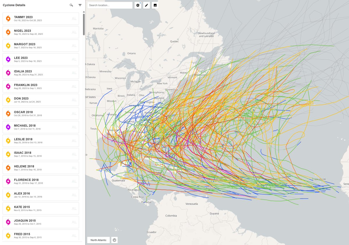
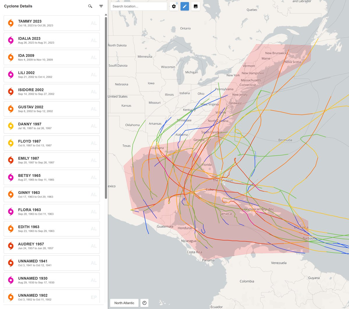
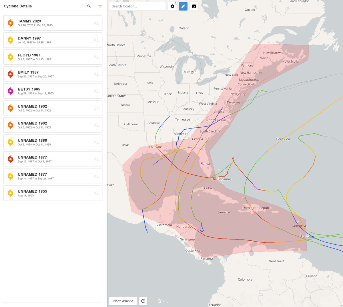
A bit late to this, but I have a website just for stuff like this. Here's a showcase of every GOM hurricane since at least 1851 to occur during an El Niño event.
The second image showcases the same thing, but for moderate and stronger events. And the third showcases them for strong events only.
New updates to my site!
- Added 5 new basins (West Pacific, North Indian, South Indian, Australian Region, and South Pacific).
- Added a new database (IBTrACS).
- Added several quality of life improvements.
Go check it out, share it, and provide feedback if possible! The site is still quite new, so any recommendations would be awesome.
Check it out: https://t.co/Cx4JAfIKi6
While less likely, intense storms and landfalls aren't unprecedented during El Niño. Freak events do occur.
Image 1 showcases every Atlantic hurricane since 1851 to occur during an El Niño. Image 2 showcases the same thing, but for El Niño events of at least +1.0°C. This is what we're likely to see with this up and coming season.
Image 3 showcases every hurricane to strike the CONUS while El Niño was present. This includes storms like 1900 Galveston, Betsy 1965, Camille 1969, Bob 1991, et cetera. So while the chance of us seeing something historical is less likely, it's not zero. El Niño is not a reason to skip your hurricane prep. And as history has shown us, it only takes one.
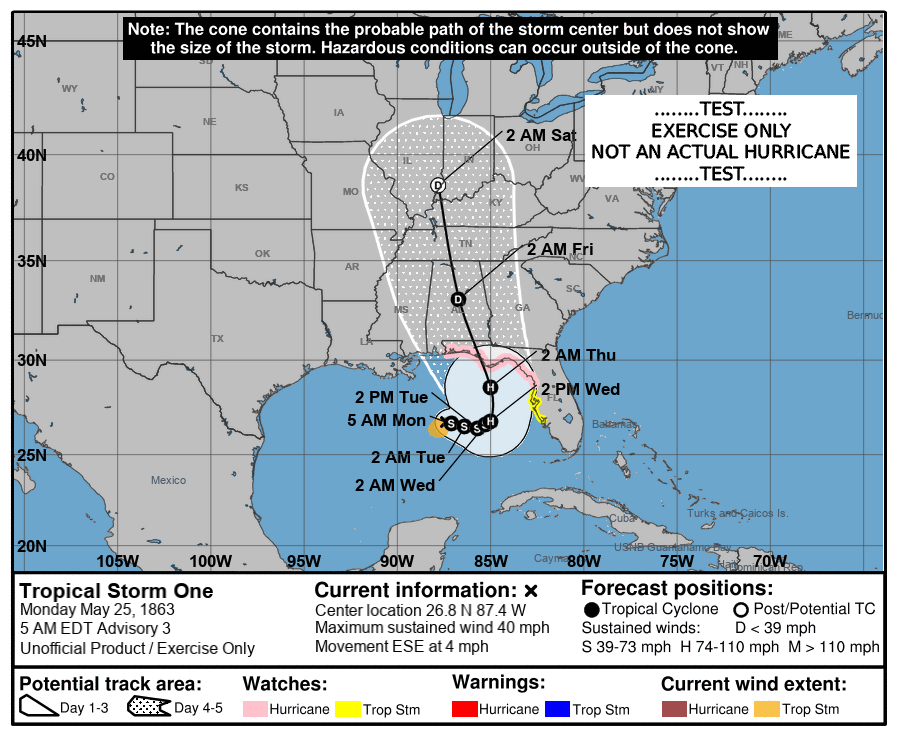
On this day in 1863, Cat. 2 Hurricane Amanda made landfall in N Florida, the only May hurricane known to hit the USA. There is a small window of no obs, which then it could have been a Cat. 3, but we declared it a Cat. 2 #hurricane Paper available at https://t.co/YccSgJxq4y
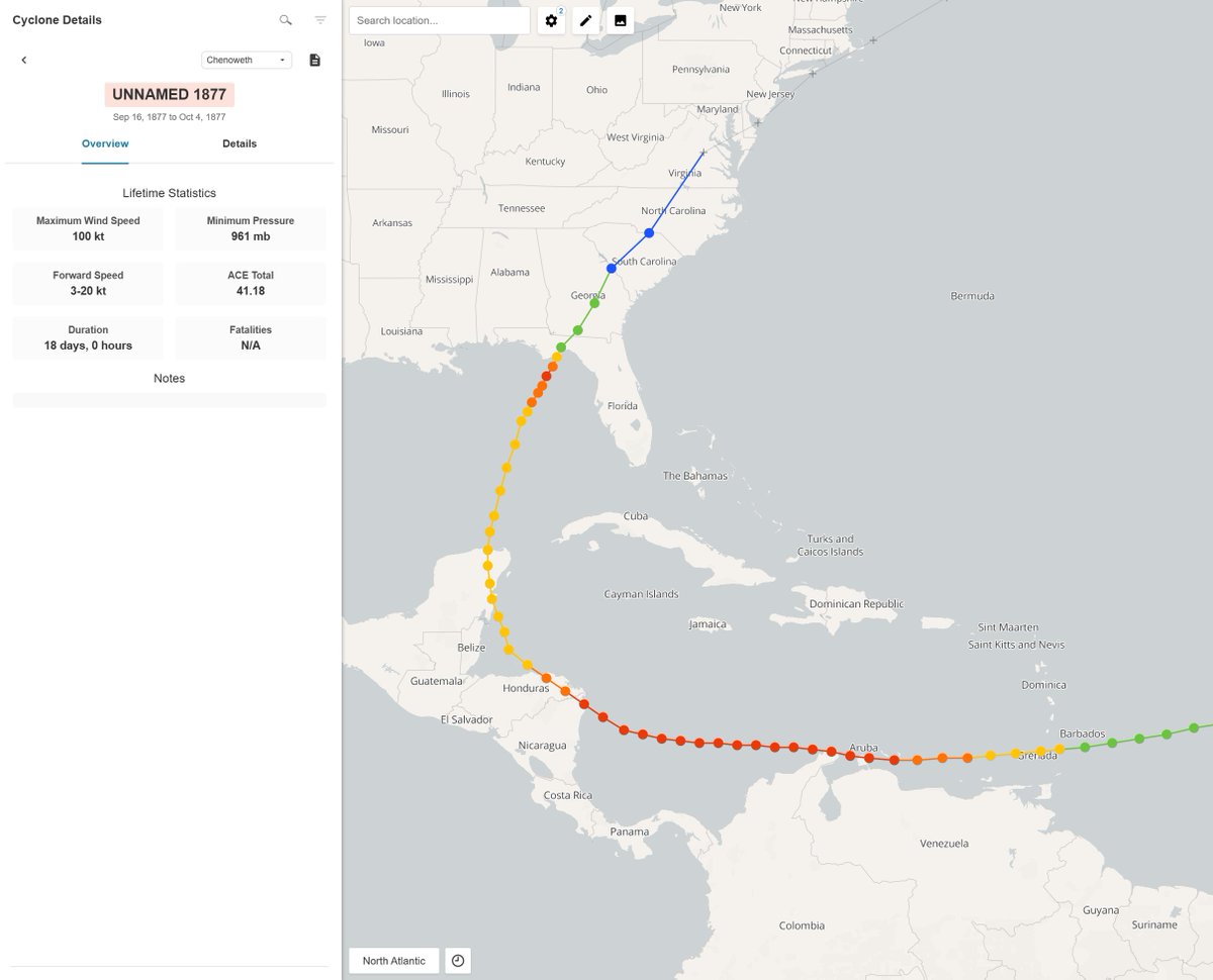
(1 of 2) As expected for this time of the year. That said, 163 years ago from this very moment, a high-end Category 2 to potential Category 3 struck Apalachicola, FL. Unfortunately, ~110 fatalities occurred.
It's the deadliest off-season Atlantic hurricane that I know of – though the 1822 Venezuela hurricane comes close. The lowest pressure measurement occurred 2 to 4 hours before landfall. There's a honest chance that this holds the record for the earliest Atlantic major.
@AndyHazelton (2 of 2) Check out this incredible work on it from @cary_mock and Michael Chenoweth. Kudos to them for putting in the necessary time and work that this system deserves. While unlikely, a similar event could occur within our lifetime.
https://t.co/LVmQOXNqiZ
@thewebpro I wouldn't change it. For one, it looks good (which is rare). And two, it's both recognizable and easy to remember.
It's unlikely that you will find something better.
Andrew 1992 is an excellent example of a hurricane striking the United States during an unfavorable set up. That said, it didn't occur in an El Niño event.
It's a prime example of "it only takes one" to make a historical season. Not often do you see storms like these, but they do happen.
It storm of that intensity, that early on would be surprising. Albeit, not unprecedented.
Here's a showcase of every Atlantic hurricane from May 15 to June 15 (since 1851). Next to this is a timeline view of every Atlantic tropical cyclone during the time of that run (within the post image above).
New updates to my site!
- Added a new "Analog" tool.
- Added a new “Polygon Statistics” section.
The analog tool (shown below) still needs work. Any screenshots or recommendations would be awesome.
Check it out: https://t.co/h70IuL5CSQ
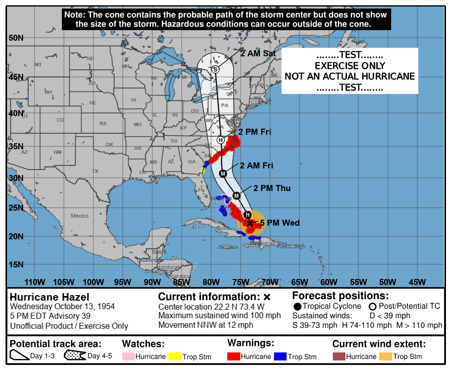
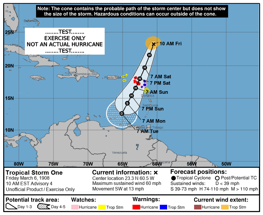
(2 of 2) Freak events do happen though. The storm on the left occurred during a Super El Niño. It struck both Venezuela, Nicaragua, and Florida as a major hurricane. Much of the track is likely underestimated too due to us lack information and reports on it.
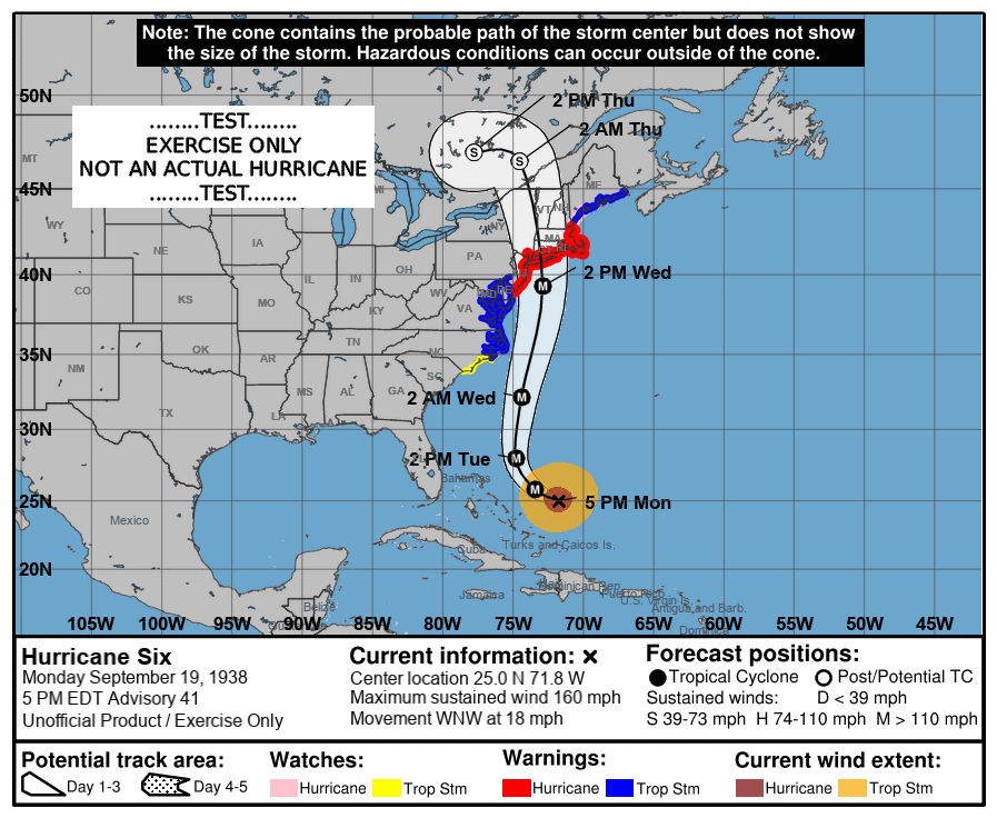
The storm on the right is one of the scariest examples though. It occurred during a Moderate El Niño. Yet despite that, it found a way to be in the wrong place, at the wrong time. The upper-end estimate on lives taken is ~8,000. Modern DR was devasted, and more likely than not, it struck at Category 5 status. I'd imagine we'll see an upgrade during its next analysis.
Indeed! Here's a extended showcase of tropical cyclones to reach hurricane status within this region (1851–2025; data pre-1899 is from Chenoweth). Major landfalls can still happen within the US (even during a Super like 1877). That said, these storms break the rule and are the exceptions. It's quite unlikely that we'll see something like it this year.
(Image Details: Moderate + Strong El Niño / Strong El Niño)