🌡️ May 2026 was the 2nd-warmest May ever recorded globally, according to the #CopernicusEU Climate Change Service.
📈 Europe experienced an early-season heatwave with W shifting rapidly from cooler-than-average to record-breaking temps in just days.
🔗 https://t.co/tSpzPOeeAX
🛰️ Decoding Madrid’s urban landscape with #CopernicusEU 🇪🇸
This visualisation combines building heights, land use/cover, and trees to reveal Madrid’s dense core, urban expansion, and green infrastructure.
🔗 https://t.co/PRJwqg8KM1
#ImageOfTheDay
¡Bienvenido @AEMET_Esp!🇪🇸
🌊We're delighted to welcome you in the #EFAS family as a new third-party partner to strengthen collaboration on #flood forecasting in Europe
🔗 https://t.co/AlbY3ecXvY
🌡️ W Europe, parts of the Atlantic & Mediterranean saw unusually warm conditions in late May.
🛰️ Based on @CMEMS_EU data, sea surface temps exceeded seasonal avg by 5°C+ in some areas. These data help monitor marine heatwaves.
🔗 https://t.co/1BqWJ8r3l3
#ImageOfTheDay#EUSpace
🔥 Wildfires in Doñana National Park 🇪🇸 (24–25 May) affected one of Europe’s key wetland ecosystems.
🛰️ #CopernicusEU Sentinel-2 shows active fire zones (orange) and burn scars (dark brown), supporting damage assessment & response.
🔗 https://t.co/bGKDxoFu1t
#ImageOfTheDay
🦌 The International Day for Biological Diversity reminds us to protect ecosystems & species.
🛰️ #CopernicusEU Sentinel-2 helps monitor Arctic ecosystems, glaciers, rivers and vegetation in protected areas like Sarek National Park 🇸🇪.
Learn more: https://t.co/KuTlofEleq
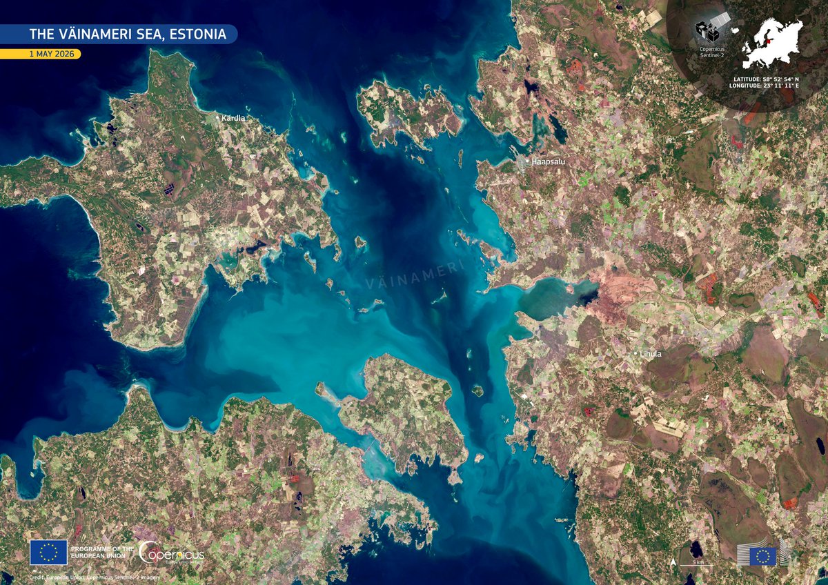
🌊 Väinameri Sea 🇪🇪 seen from space by #CopernicusEU Sentinel-2.
🛰️ Bright blue sediment-rich waters reveal the dynamics of one of Estonia’s most valuable coastal ecosystems, supporting marine monitoring & environmental protection.
🔗 https://t.co/ZyPhGlouMc
#ImageOfTheDay
🇪🇺 Europe Day celebrates the spirit of cooperation that built the EU.
🛰️ #CopernicusEU reflects that same ambition: achieving together what no country could achieve alone.
This Sentinel-2 visualisation shows the 27 EU Member States from space.
🔗 https://t.co/w9pj2QET7M
Understanding how Earth’s surface changes is key to tackling deforestation, biodiversity loss & climate impacts.
CLMS launches new global land cover & forest products at 10m resolution.
Read more 👉 https://t.co/8pjyTAiCjv
#CopernicusEU
The DRMKC Flash News April 2026 is out.
It features EFAS v5.6, the 2025 EU wildfire season or the new #GHSL method for high-resolution nighttime light mapping.
Plus the latest on DRR research, tools, and funding calls.
👉 https://t.co/c0Us6sFsb7
#Disasters#RiskManagement
🛰️ Hello Sentinel-3C!
At the @Thales_Alenia_S clean room the newest #CopernicusEU satellite is being prepared before its journey to Kourou.
It will ensure the continuity of the mission and providing data for oceans, land, ice & atmosphere.
🚀 Launch planned for autumn 2026.
Γεια σου Ανάφη από ψηλά! 🛰️
Situated in the southern Aegean Sea, #Anafi is a small island with rugged terrain, sparse vegetation and a largely undeveloped coastline.
#Sentinel2 data support monitoring of coastal dynamics and shoreline change across remote Mediterranean islands.
🌡️ Copernicus Climate Change Service reports March 2026 was the 4th-warmest globally (+1.48°C above pre-industrial).
🌍 Maps show strong contrasts: heat in the US & Arctic, colder zones in Canada & parts of Europe.
🔗 https://t.co/i5xtJ3EShu
#CopernicusEU#ImageOfTheDay
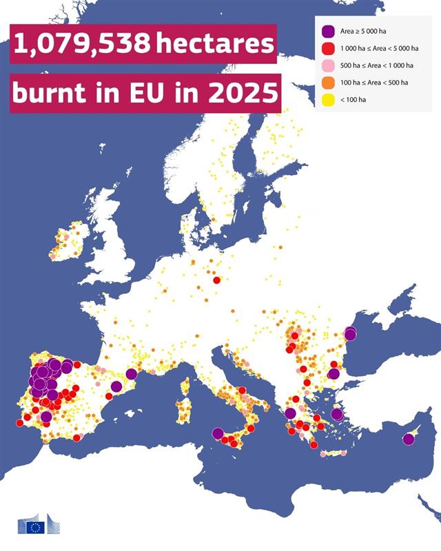
2025 was a record year for wildfires in the EU and beyond. In part because of:
🟠Early fires
🟠Intense heatwaves
🟠Fires in higher latitudes
Wildfire activity was especially high in 🇵🇹, 🇪🇸, southern 🇫🇷 and southern 🇮🇹, 🇬🇷, 🇹🇷, 🇺🇦 and parts of the 🇬🇧.
👉https://t.co/phX0Q5nRG0
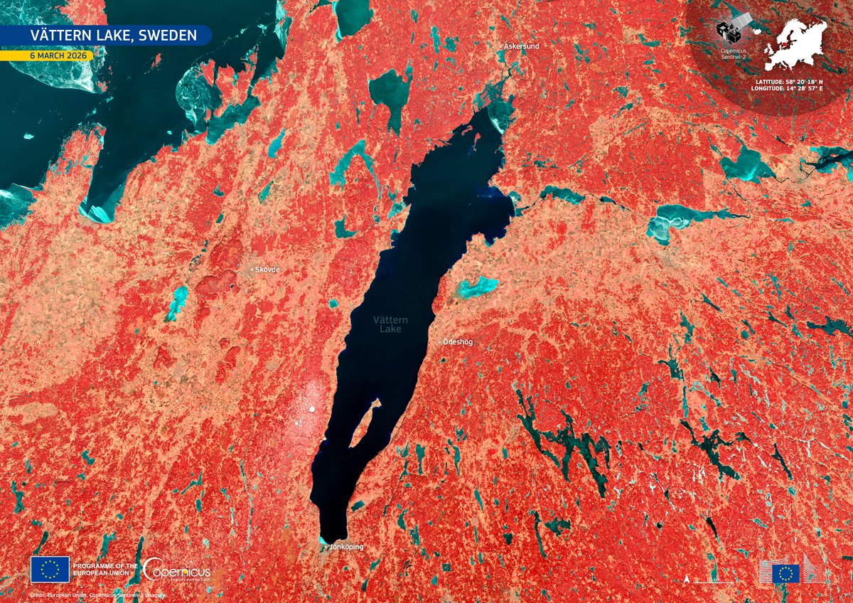
💧 22 March is World Water Day 🌍
#CopernicusEU Sentinel-2 captures Lake Vättern 🇸🇪 - one of northern Europe’s key freshwater sources, known for its crystal-clear water.
🛰️ data track water quality, land use & environmental pressures.
🔗 https://t.co/2kWbzxsXDg
#ImageOfTheDay