Vantor is forging the new frontier of spatial intelligence to unlock a more automated, interoperable world. Delivering total clarity from space to ground.
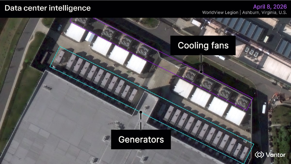
Data center growth is moving fast, and bringing them online takes capital, construction coordination, power capacity, and more.
Physical changes on the ground can reveal how quickly a site is advancing, what capacity may be coming online, and whether development activity aligns with an investment thesis. The strongest market signals are not always found in public reporting.
With Vantor’s spatial intelligence, finance teams can monitor signals such as building scale, generator and cooling infrastructure installation, equipment placement, and visible operational activity across regions or portfolios.
That clearer view at a regular cadence can help investors and analysts track market movement, assess development risk, and identify emerging capacity before it is widely reported.
Read the full blog to learn how spatial intelligence can support data center market intelligence: https://t.co/YtK7PTadLV
This is a spent Chinese Long March 3B rocket body, imaged by a Vantor WorldView Legion satellite from 88 km away.
The image quality is not simply about range. It reflects the strength of Vantor’s advanced WorldView constellation and high-performance imaging hardware, which enable detailed observation of objects in orbit.
It’s a powerful example of Vantor’s NEI tasking through our WorldView Space product line: using high-resolution satellites to look out into space and capture detailed imagery of objects in orbit.
Why does that matter? Most tracking systems can show where an object is. WorldView Space NEI helps show what it is, its structure, orientation, condition, and potential risk. It can also support Movement Analysis, helping operators understand whether an object is intact, tumbling, spinning, or otherwise changing behavior over time.
That level of detail is especially important for large rocket bodies like this one. They are big, long-lived debris objects that share orbits with critical infrastructure, including communications, Earth observation, weather, science, and national security satellites. A single collision involving an intact rocket stage can create thousands of new fragments, increasing risk across already crowded orbital regions.
As launch activity accelerates, we need to understand not just where objects are in space, but what they are, how they are moving, and how they may behave over time.
The future of geospatial intelligence is not defined by a single sensor — it is defined by how multiple sources of intelligence come together.
At SmallSat Europe, Matthew Jenkins joined the panel “The Multi-Physics EO Stack: Fusing SAR, Thermal, and Hyperspectral,” alongside industry leaders to discuss how advanced geospatial intelligence is evolving through multi-source data fusion, common tasking, and AI-enabled analytics.
As highlighted in a recent @SatNewsEvents article, “The pixel war is over. The integration war is what comes next,” the competitive frontier in Earth observation is moving beyond imagery alone. The next phase is about delivering fused intelligence into customer workflows — combining optical, SAR, thermal, hyperspectral, and other data sources to help users move faster from question to answer.
Great discussion from Matt and the panel on where the EO industry is headed next.
Read the full SatNews article here:
https://t.co/mlxFVS8765
The future of spatial intelligence is being built now — and Vantor is looking for the talent to help lead it.
Connect with our recruiting team at the @ClearanceJobs Polygraph Only Virtual Hiring Event on June 3 and discover opportunities to work on mission-driven technology that makes an impact. We’re hiring software engineers, full stack developers, data analysts and software developers who are ready to solve complex challenges and push boundaries.
At Vantor, we’re seeking curious thinkers, technical innovators and driven professionals who want to help build what’s next.
If you're ready to make an impact, we want to meet you.
Register today: https://t.co/GnolMM5qSc
Raptor was built for the realities operators face now: contested signals, complex terrain, and fast-moving decisions that depend on accurate geospatial data.
In May, our team brought that message to five industry events: SOF Week in Tampa, GXP360 Professional Exchange in San Diego, XPONENTIAL in Detroit, DAIMEX Baltic 2026 in Lithuania, and the Loitering Munitions Systems Summit in Virginia.
The discussions varied by audience, but across booths, briefings, and customer discussions, two themes stood out:
1. The core need is consistent: teams, especially government customers, want more reliable ways to navigate, interpret, and act on aerial data when GPS is unreliable.
2. Autonomy is on the rise. Maintaining communications over longer ranges is becoming increasingly untenable. Systems must be able to perform their missions on their own.
At GXP360, one point was especially clear: The GXP community is highly dedicated, technically engaged, and passionate about geospatial intelligence. Attendees quickly saw how Raptor Sync can support full-motion video processing by bringing Raptor’s geospatial alignment capabilities into the GXP software suite.
For the Vantor team, the past month was a valuable reminder: the market is not looking for more complexity. It is looking for practical, flexible software that helps turn sensor data into trusted location insight.
Learn how Raptor supports that work: https://t.co/j9VSbhcyNk
True sovereign intelligence capability isn’t defined by how much space-based data you collect. It’s defined by whether you can turn that data into a consistent operational picture fast enough to matter.
Today, many national strategies are focused on expanding inputs: satellites, sensors, AI models. All essential. But sovereignty doesn’t end at collection.
It depends on what happens next:
• Can you align multi-source intelligence into one ground truth, even as you bring on new sensors?
• Can you maintain that ground truth as conditions change?
• Can you deliver it into operations, integrated across your ecosystem, without rebuilding it every time?
That’s the difference between owning data and controlling outcomes.
The nations moving fastest aren’t replacing existing investments. They’re connecting them around a shared, continuously maintained ground truth.
Vantor’s Elie Tabchouri, EVP and GM of our International Government business, explores what this shift means — and what it actually takes to achieve sovereign intelligence — in his latest blog:
https://t.co/2o3qvatXxK
This Memorial Day, we honor the memory, sacrifice, and enduring legacy of the men and women who gave their lives in service to the United States.
From the historic heights of Mount Suribachi on Iwo Jima to memorial sites around the world, preserving these places helps ensure their stories are never forgotten.
We believe conserving history helps future generations better understand the courage and sacrifice that shaped it.
Today, we pause to remember the heroes who served and sacrificed. 🇺🇸
The GIS community within the energy industry continues to push for geospatial workflows that are more connected, current, and operationally useful. That theme came through clearly at this week’s Esri Energy Resources GIS Conference in Houston.
Thank you to the @Esri team for hosting a productive event, and to our customers, partners, and new connections who joined us for conversations throughout the week.
Here's three other takeaways from the week:
🌐 Teams are prioritizing georegistration across their data stacks to enable more efficient analysis. We appreciated the opportunity to share how Tensorglobe can support this type of work as organizations look to align and analyze complex geospatial data more effectively.
🛰 Customers are eager to explore Vantor Hub and understand how improved refresh rates from our expanded constellation can support their operations.
✨ In-person connection still matters, and The Grove was a great setting to continue the conversations after hours.
Missed us at the conference? Connect with us online: https://t.co/WrsiWJXQHm
In a few minutes, @SpaceX is set to launch Starship from Boca Chica, Texas, continuing one of the most ambitious campaigns in modern spaceflight. At 4:52 p.m. CDT—barely an hour ago—Vantor captured this high-resolution image of Starship on the launchpad with one of our WorldView Legion satellites.
Wishing SpaceX lots of luck for today’s launch. At Vantor, we’re continuing to watch the future of space from space.
Accuracy is more than a technical detail. It’s what makes geospatial data usable in the real world.
When imagery is accurate, everything built on top of it becomes more reliable: maps align more cleanly, mosaics look sharper, and roads, bridges, and overpasses appear where they should, without distortion. Accuracy also makes it easier to combine different data sources into one trusted view of the world. That matters for applications like autonomous navigation, infrastructure monitoring, and AI/ML analysis, where even small errors can lead to missed insights or false detections.
Vantor’s constellation collects the most accurate commercial satellite imagery available. Every pixel is within 5 m of its real-world location. Our 3D imagery offers even greater precision, with accuracy down to 3 m in all dimensions.
The better the accuracy, the better the decisions. How accurate is the intelligence you rely on?
We’re here at #SOFWeek2026 in Tampa to connect with the global special operations community and our partners helping deliver advanced real-time intelligence capabilities to the warfighter.
This week, we’re showcasing Vantor’s Tensorglobe-powered 3D capabilities, which deliver an up-to-date view of the operational terrain directly to warfighters and the autonomous systems that support them. Our highly accurate 3D maps—updated within hours of a new satellite pass—help operators better understand the mission environment as it truly exists. This enables more effective elevation and line-of-sight analysis, as well as enhanced situational awareness for mission planning and live tactical operations.
As a result, every warfighter and machine operates from the same precision-aligned operational picture, helping teams move faster, plan with greater clarity, and operate with confidence in complex and contested environments.
Stop by Booth #307 to meet the team, see the capability in action, and learn how Vantor is delivering mission-ready geospatial intelligence where it matters most.
Increased use of drones and degraded GPS are changing the reality of modern conflict.
That is why @BAESystemsInc GXP and Vantor are delivering more resilient targeting from drones operating in contested environments.
By leveraging Raptor alongside GXP InMotion™ and SOCET GXP® workflows, teams can correct video metadata at the edge and turn full-motion video into accurate, actionable ground coordinates.
The result is stronger intelligence continuity, more resilient workflows, and greater targeting confidence when traditional telemetry cannot be trusted.
In contested operations, location accuracy is mission critical.
Learn more: https://t.co/fpFMpUEvGV
The era of single-source tracking is over.
On Day 1 of Operation Epic Fury, 1,100 vessels hit GPS & AIS interference. With 100+ dark events daily in the Gulf, AIS alone is no longer enough.
Join Windward & @vantortech to see how fusing satellite imagery, RF, and behavioral analytics reveals what happens when the maritime domain goes dark.
May 20 | 10AM EST | 3PM BST
https://t.co/UV9iOOfkUV
Energy operations depend on timely, accurate geospatial intelligence.
At the @Esri Energy Resources GIS Conference, Vantor will be sharing how teams use our capabilities to:
• Monitor critical assets like pipelines and facilities to detect anomalies and emerging threats early
• Plan and manage operations with accurate, up-to-date terrain and imagery
• Protect infrastructure onshore and offshore
• Spot physical market signals earlier
We hope to see you in Houston, May 18–20. We’ll be at booth #303!
We’re also hosting Vantor On Tap—relaxed evening to connect with peers, enjoy food and beverages, and continue the conversation beyond the conference floor.
Register to join us: https://t.co/xHUwnopuL9
When GPS is unreliable, autonomy needs another path. That’s what Raptor is built for.
Raptor enables autonomous platforms to navigate by aligning onboard camera feeds with Vantor’s global 3D spatial foundation. The result is resilient positioning and precise ground coordinate extraction without relying on satellite signals.
Here's why Raptor catches the attention of teams leveraging drones:
➡️ GPS-independent navigation in contested environments
➡️ Accurate ground coordinate extraction from full-motion video
➡️ Easy integration with existing platforms and cameras, with no additional hardware required
➡️ A shared spatial reference that supports mission execution across systems
If you’re heading to SOF Week next week, stop by the Vantor booth to see Raptor.
Learn more: https://t.co/ctTff9hm5t
The strongest technology conversations start with the customer’s problem.
For Kara Kramer, Vice President of Raptor Sales at Vantor, that problem is clear: autonomous systems are being asked to operate in environments where GPS can no longer be assumed.
Kara recently appeared on the Sales Lead Dog podcast, which explores the people, practices, and leadership behind successful sales organizations. Her conversation with Christopher Smith covered what it takes to lead a global sales team at the intersection of drone technology, national security, and customer need.
In the episode, Kara explains how Raptor gives drones another way to navigate when GPS is jammed, spoofed, degraded, or unavailable.
As she puts it: “[Drones] need to be able to rely on maps. What Raptor does is bring the power of our 3D model of the world on board the drone. It’s preloaded, so you don’t need connectivity.”
The discussion also covers Kara’s path from the intelligence community to defense technology sales, why demos matter in the drone industry, and her belief that sales is not about selling a product. It is about solving the customer’s problem.
Listen to the full episode of Sales Lead Dog: https://t.co/zpSk0rQxPF
TODAY at #AIExpoDC.
The maritime domain is becoming a theater of deliberate opacity. Solving this challenge requires autonomous analysis at scale to deliver a unified operational picture for actionable defense and intelligence.
Join us for a two-part session exploring the future of maritime intelligence:
- A Fireside Chat with Windward’s Jonathan Goldman and @vantortech's Michael Bergen, moderated by @JeanneMeserve to discuss the convergence of space-based EO and AI.
- A Live Demo with Windward's Nadav Libhaber for a first-look at Maritime Agentic AI in action, transforming raw sensor data into mission-ready intelligence.
TODAY, May 7 | 2:30 PM - 4:00 PM | Room 103B
https://t.co/um8YgK0EZY
Susanne Hake, Vantor’s U.S. Government Lead, joined @JohnSewardDC for Threat Status by @WashTimes to discuss how space is evolving into an increasingly contested domain — and why non-Earth imaging matters.
At Vantor, we’re known for Earth imaging. But our capabilities also extend beyond Earth: enabling the detection, imaging, and characterization of objects in space to help build a clearer understanding of the orbital environment.
As governments look to integrate commercial and government capabilities more closely, commercial space-based intelligence is becoming an important part of space domain awareness.
Watch Susanne’s remarks from the interview below.
Hear the full conversation: https://t.co/ajch9Yyflq