Like most of you, I've been watching the Thursday-Friday setup develop the past couple of days. Strong Gulf moisture returns, eastern trough digging in, shear profile looking increasingly classic.
The more people who are weather-aware, the safer we all are as a community.
That's the idea behind what I've been building for the past 12 months. It's called Vortex, https://t.co/qND7hZ0I11 — a platform where you can trade markets on exactly this. Live tornado warnings, flash flood markets, hail reports, etc., NWS-driven, auto-resolved.
It's a prediction market wrapped in a situational-awareness platform.
Paper-trading only for now. Starts with $1k practice balance.
Timed this launch for a quiet week on purpose. Didn't quite work out.
🌡️ Heat Advisory through tonight across south-central IL—highs near 95°F with humidity making it feel worse. Moderate impact but real feel could spike higher. Paper trade the odds at https://t.co/hqtMDrQpgx while we work toward launching real markets. #wxmarkets#heatadvisory
🌪️ TORNADO WARNING: Adams County ND until 9PM CDT. Extreme threat — take shelter NOW if in path. This is happening. Paper trade severe weather scenarios free at https://t.co/hqtMDrQpgx while we work toward real markets. #TornadoWarning#SevereWx
⛈️ DESTRUCTIVE severe thunderstorm warning just issued for Adams/Grant/Hettinger ND until 9:45pm CDT. Damaging winds, large hail, tornadoes possible. Take shelter NOW. Track the odds free at https://t.co/hqtMDrQpgx while we work toward real markets. #SevereWx#NorthDakota
⛈️ DESTRUCTIVE storm hitting NW ND right now. Seek shelter immediately if you're in Adams, Hettinger, Slope, or Stark counties. This is life-threatening. Watch live at https://t.co/hqtMDrQpgx (free demo — real markets coming post-approval) #SevereWx#NDStorm
Bowman County, ND looking dicey for quarter-sized hail today. Market's sitting at 45% YES — which honestly feels a bit low given the wind shear profile. Paper trade it free at https://t.co/hqtMDrQpgx while we work toward real markets. ⛈️ #SevereWx#HailForecast
🌪️ TORNADO WARNING: Lyon KY until 7:15PM CDT. Extreme threat. Take shelter NOW if in path. Track severe weather odds free at https://t.co/hqtMDrQpgx while we work toward real markets. #TornadoWarning#SevereWeather
🌪️ TORNADO WARNING: Livingston, Lyon & Marshall Counties KY until 6:45pm CDT. Extreme threat. Take shelter NOW. Paper trade severe wx scenarios free at https://t.co/hqtMDrQpgx while we build toward real markets. #TornadoWarning#KentuckyWeather
🌪️ TORNADO WARNING: Massac/Pope County IL + Lyon/McCracken/Marshall County KY until 6:15p CDT. Extreme threat. Follow NWS alerts closely. Paper trade the severe weather odds free at https://t.co/hqtMDrQpgx while we work toward real markets. #SevereWx#Tornadoes
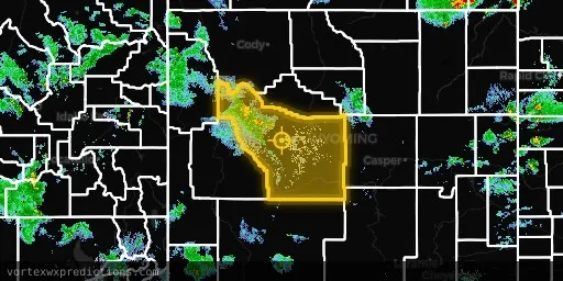
⛈️ SEVERE THUNDERSTORM WARNING just dropped for Fremont, WY through 4:30pm MDT. This one's got teeth — 87/100 impact score. Track the odds free at https://t.co/hqtMDrQpgx while we work toward real markets. #SevereWx#WyomingWeather https://t.co/hqtMDrQpgx
🌪️ TORNADO WARNING: Massac IL & McCracken KY until 5:30pm CDT. Extreme threat — seek shelter NOW. Track the odds free at https://t.co/hqtMDrQpgx while we await approval for real markets. #TornadoWarning#SevereWx https://t.co/hqtMDrQpgx
Campbell County, WY cell showing some organization on radar right now. Market's pricing a tornado upgrade at just 22% — seems low if this thing keeps tightening up. Free to forecast at https://t.co/hqtMDrQpgx while we work toward real money markets. 🌪️ #wxmarkets#Wyoming
⛈️ Marion FL under Severe Thunderstorm Warning until 5:15p EDT. Large hail & damaging wind possible. Paper trade the odds free at https://t.co/hqtMDrQpgx while we work toward real-money markets. #SevereWx#FLwx https://t.co/hqtMDrQpgx
⛈️ Severe Thunderstorm Warning just dropped for Greene, Taliaferro, Warren & Wilkes counties GA until 3:15pm EDT. Strong winds & hail risk. Paper trade the odds free at https://t.co/hqtMDrQpgx while we work toward real markets. #SevereWx#GAWeather https://t.co/hqtMDrQpgx
Sussex County, DE has some severe storm potential brewing, but the hail signal is still pretty modest — markets are pricing a 1"+ event at just 27%. Track the odds free at https://t.co/hqtMDrQpgx while we work toward CFTC approval. ⛈️ #DelawareWeather#SevereWx
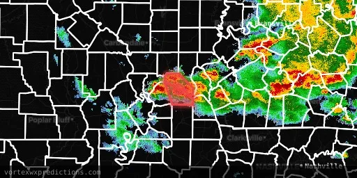
⛈️ Severe Thunderstorm Warning live for Alexander, Union, Cape Girardeau & Scott counties until 12:45pm CDT. Damaging winds + hail possible. Paper trade the odds free at https://t.co/hqtMDrQpgx while we work toward real markets. #SevereWx#WxMarkets https://t.co/hqtMDrQpgx
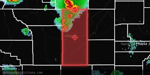
⛈️ Severe Thunderstorm Warning just dropped for the Black Hills—Custer, Fall River, Oglala Lakota, Pennington counties until 8PM MDT. Track these odds free at https://t.co/hqtMDrQpgx while we work toward real-money markets. #SevereWx#BlackHills https://t.co/hqtMDrQpgx
💨 Dust Storm Warning just dropped for Luna, NM through 7:30pm MDT — visibility dropping fast out there. Track the odds free while we build toward real markets at https://t.co/hqtMDrQpgx #DustStorm#NMWeather https://t.co/hqtMDrQpgx
🌪️ TORNADO WARNING: Douglas, MO until 7:00 PM CDT. Extreme threat — seek shelter NOW. Track this one free at https://t.co/hqtMDrQpgx while we build toward real markets. #TornadoWarning#MissouriWeather https://t.co/hqtMDrQpgx
🌪️ TORNADO WARNING: Alexander & Pulaski IL, Ballard KY, Mississippi MO until 5PM CDT. Extreme threat. Take shelter NOW. Track this on our free demo at https://t.co/hqtMDrQpgx while we work toward real markets. #TornadoWarning#SevereWx https://t.co/hqtMDrQpgx