Keeping an eye on the chance for strong storms Sunday afternoon and evening across southeast Virginia. The primary threats will be damaging wind gusts and frequent lightning if storms are able to form.
We are in for a hot one today across Hampton Roads. A light sea breeze will keep the coast slightly cooler so if you want to cool off the beach won't be a bad idea.
High pressure remains overhead for the rest of today which means beautiful weather is in store for Hampton Roads! Are you outside enjoying this nice weather?
While the Atlantic Basin remains quiet in terms of tropical activity the Eastern Pacific has its first named storm of the season. Tropical Storm Amanda is no threat to land and will be on a weakening trend this weekend.
The rip current risk remains elevated tomorrow due to onshore winds. Be careful if you are headed to the coastline and if you plan on swimming make sure you listen to what lifeguards are telling you. The rip current risk for the Outer Banks will be higher tomorrow due to larger surf.
A Severe Thunderstorm Watch is in effect for southeast Virginia until 9pm this evening. The primary concerns will be damaging straight line wind gusts of 65mph or greater and isolated hail up to ping pong size.
Southeast Virginia is now included in a Slight Risk (Level 2) for severe weather tomorrow afternoon. Damaging wind gusts of over 60mph is the primary risk. Storms will likely get started during the later afternoon hours and continue into the early evening.
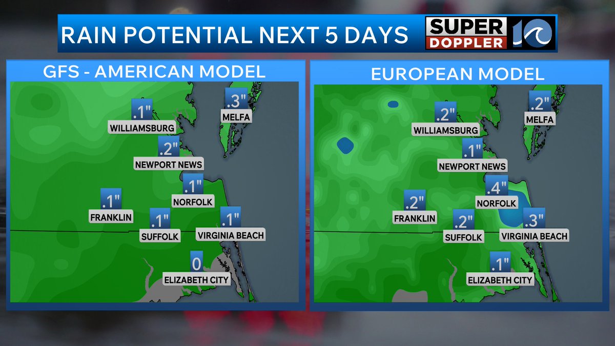
Memorial Day weekend across Hampton Roads is not expected to be a total washout but you will have to be prepared for daily chances for rain and thunderstorms.
The summer surf contest season kicks off tomorrow at the 1st street Jetty in Virginia Beach! The Steel Pier Classic is back and it looks like Mother Nature is pulling through with a new swell which will last through the contest period!
This afternoon marks the start of an unsettled pattern heading through Memorial Day weekend! Scattered showers and thunderstorms are possible this afternoon with more rain coming for the next several days.
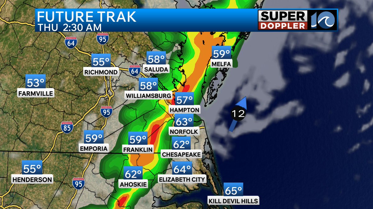
Scattered showers and thunderstorms are set to move in during the day on Thursday. A few downpours are possible allowing for some much needed rainfall. This will kickoff an active rainy pattern ahead as we head into Memorial Day weekend.
A front will move in and stall across Hampton Roads heading into Memorial Day weekend. While we are not anticipating a total washout there will be daily chances for rain as long as the front stays around.
Get ready to heat up Hampton Roads! Highs will reach the upper 80s and low 90s this weekend and into early next week as high pressure slides offshore. This will also bring up our dew points making it feel more like summer!
It is really dry out there across Hampton Roads as dew points are sitting in the 30s and 40s! We will see a slight increase tomorrow ahead of a cold front but the larger increase in humidity will come this weekend.
Temperatures will climb this weekend and into early next week as a ridge builds in across the Eastern US. Highs right now look to top out in the 80s along with an increasing in dew points. The 6-10 day outlook by the climate prediction center has Hampton Roads in a high probability of seeing above normal temps through the end of next week.
Keeping an eye on the chance for heavy rainfall Wednesday night into early Thursday. This will be as a fast moving cold front moves through Hampton Roads. Areas that see heavy downpours may see a quarter to a half inch of rain. Stay tuned as timing of this line is likely to change.
Some patchy morning fog will be around early tomorrow morning for inland areas. Once the sun comes up this fog will quickly burn off allowing for a beautiful sunny Tuesday with highs around 70 degrees!