CEO of Regrid — @regridapp (formerly known as Landgrid by Loveland Technologies). Resident of Michigan’s Upper Peninsula via Detroit via other places. ✌️ 🗺
Fast. Beautiful. Easy to use. No, I’m not working on an updated bio. I’m describing the brand new https://t.co/fdgsdS1LZs.
The entire American parcel fabric is clear and seamless and one click away on a map in your browser.
Click through to see for yourself.
From humble booths with wrinkled backdrops to video walls and hosting panel sessions—Regrid leveled up at @Esri UC 2025.
This year:
☑️ 19 teammates
☑️ Won “Best Use of Technology” for our booth
☑️ And, of course, tacos. 🌮
Read CEO @WELLO's recap: https://t.co/YVPeKzcPs8
Regrid has landed at #EsriUC2025 — and we showed up BIG. With 19 Regrid team members in town, this is our largest @Esri UC presence yet!
Come find us in the Expo Hall at booth 727.
Let’s make this our best year ever at #EsriUC. See you soon!
@GIS_DOG My elaborate plan worked perfectly! 😄 Nice to connect, Jeff! Please don’t be a stranger. I’m hitting the plenary too, & I’ll be milling around the @regridapp booth 727 & doing a panel on Tuesday at 11 AM if you’re looking for content in a sea of content: https://t.co/Dj1zM4SIrJ
🧠: “Ope, headed to #EsriUC2025, better post something on X for the first time in a long time with a hashtag in case it leads to one extra connection. Hmm. What to say… I know. I’ll just screenshot too many words from LinkedIn. That’ll do it. Perfect. Don’t want replies anyway.”
What could go right?
A few weeks ago, the Regrid team gathered in Detroit to ask just that—and the answers were inspiring. From big ideas to tangible plans, our 2025 Summit was all about shaping what’s next.
CEO @WELLO breaks it all down in his blog post: https://t.co/Tcj0iU4GR6
This Thursday: Regrid CEO @WELLO joins top data leaders at the @worldofdaas Summit in D.C.
This invite-only event brings together 200 influential voices across tech, government, and national security.
Stay tuned for insights from the summit!
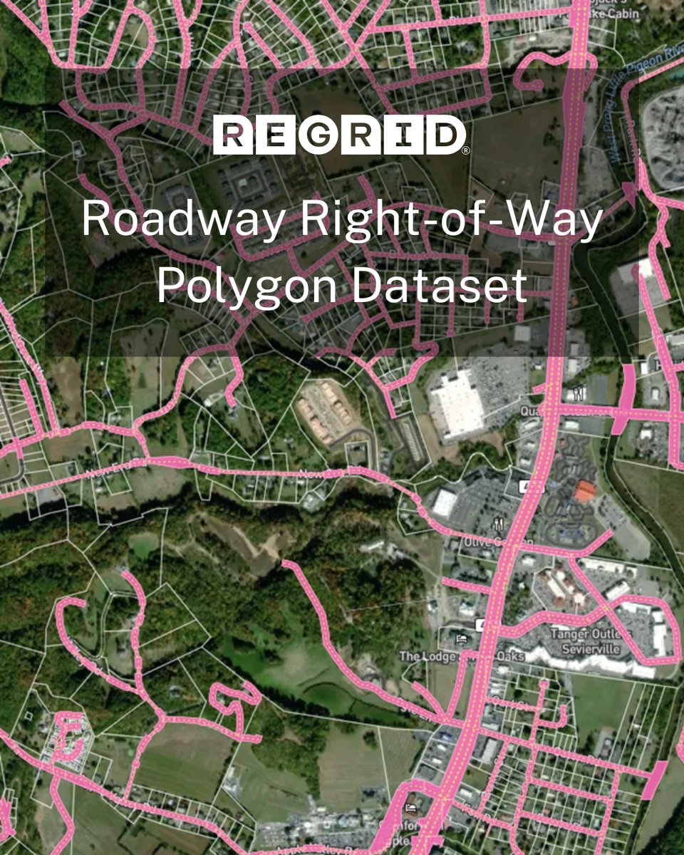
Introducing a new spatial data product from Regrid: Nationwide Roadway Right-of-Way Polygons.
For the first time ever, you can go beyond road lines and clearly identify road and rail right-of-ways nationwide.
Last month, we expanded our Premium Parcels with geographic enrichments through our partnership with @Esri. Now, our CEO, @WELLO shares what this means for Regrid and the future of parcel data.
Read the blog - https://t.co/Sq3LPPeXuJ
Regrid is at #FedGIS! Meet CEO @WELLO & CFO Steve Stautzenbach at booth 907 and explore how our parcel data integrates with Esri.
Learn more about our partnership - https://t.co/liTkNmxs3d
Also: NORCO is 60% off through March 8th on Steam. Float above Greater New Orleans, infiltrate a refinery, get in the ditch with your pawpaw. Point & click graphic adventure in the style of Snatcher or Deja Vu.
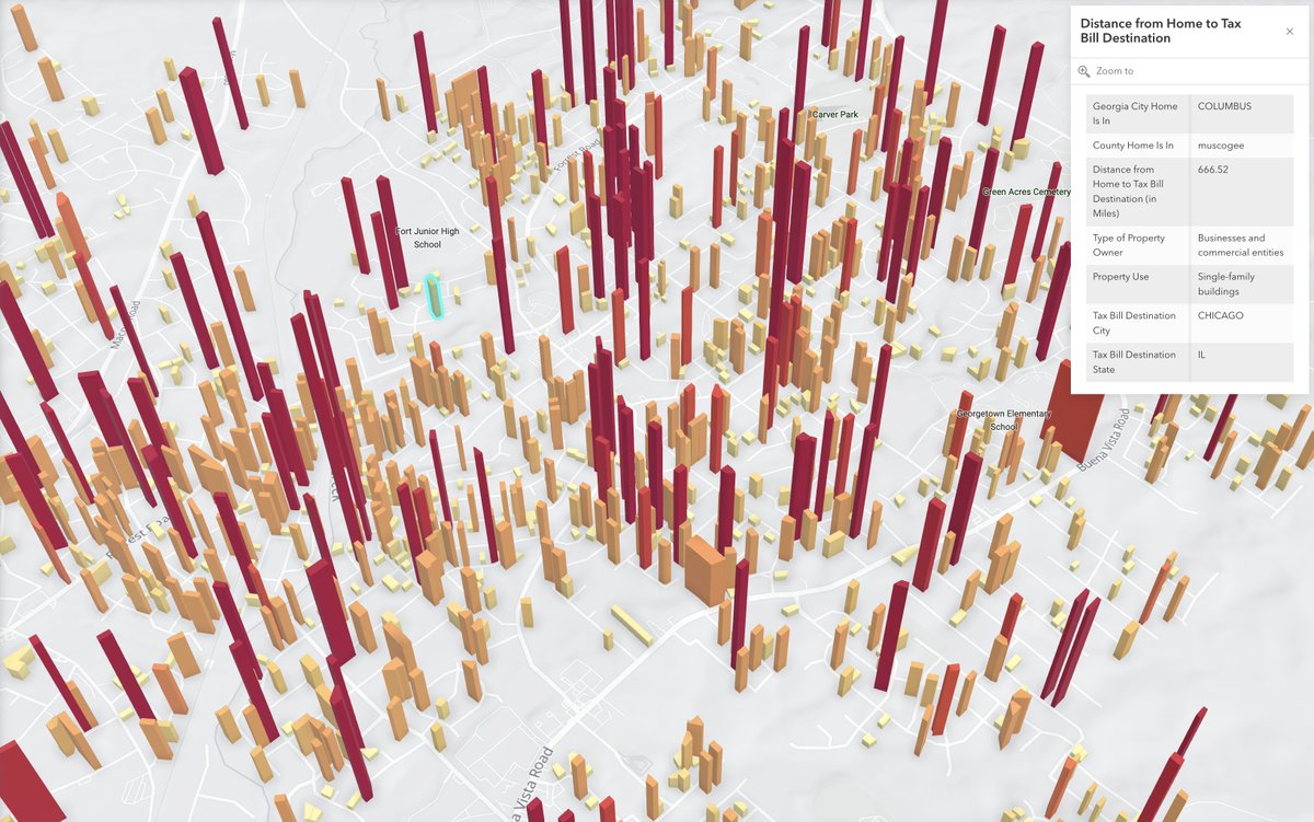
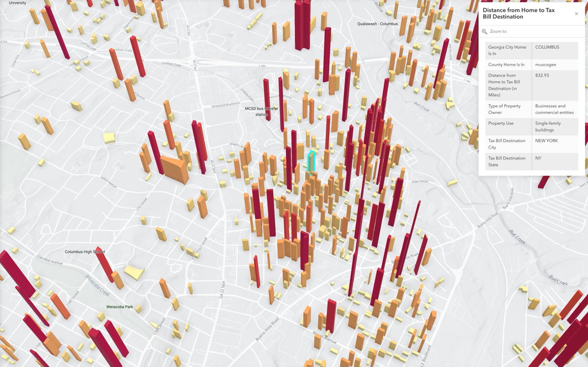
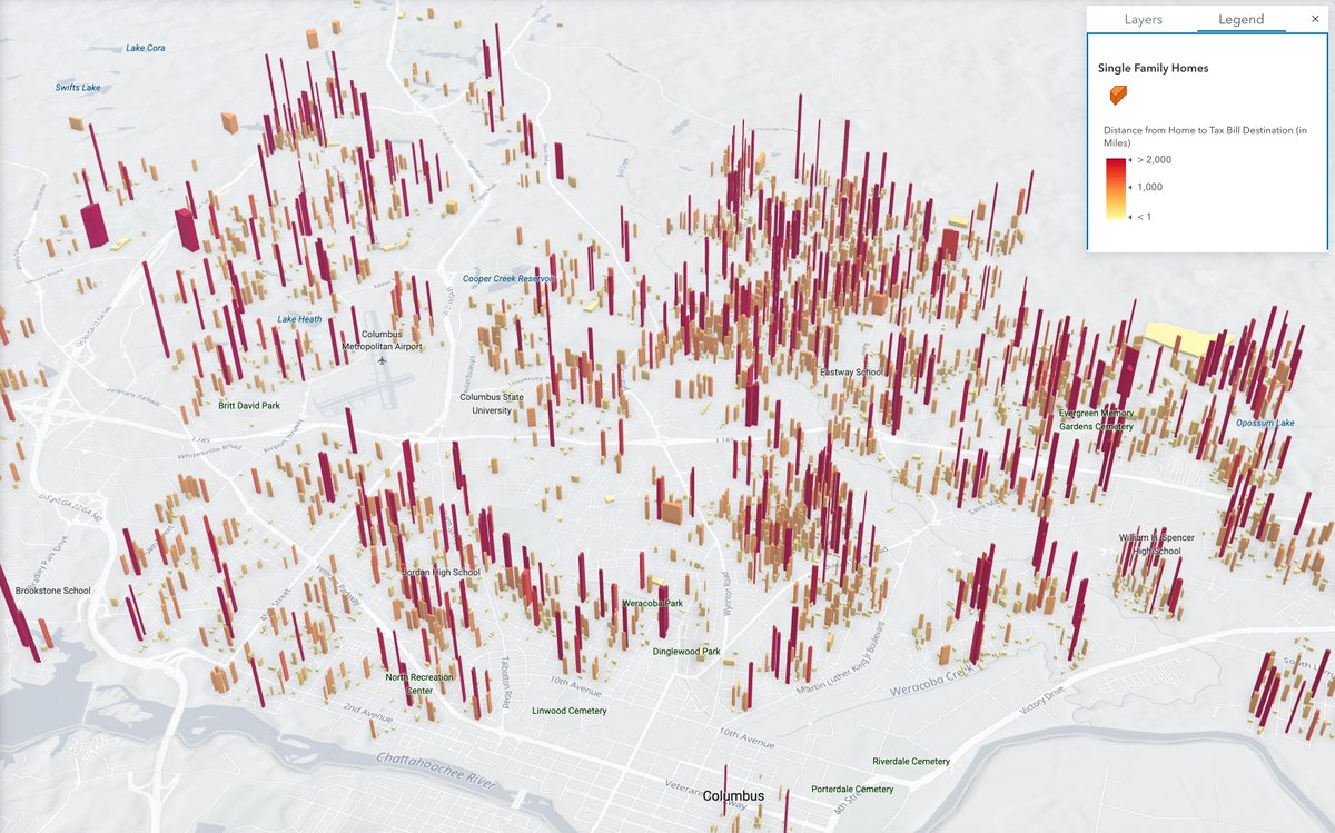
Trying out ways to show distance between housing & where ownership of housing may sit. Been interested in out of state investment activity in Columbus, GA.
Taller the parcel, farther ownership of the property sits. ~10% of homes owned >50 miles away, in some areas 25-30%. Done with @regridapp data.
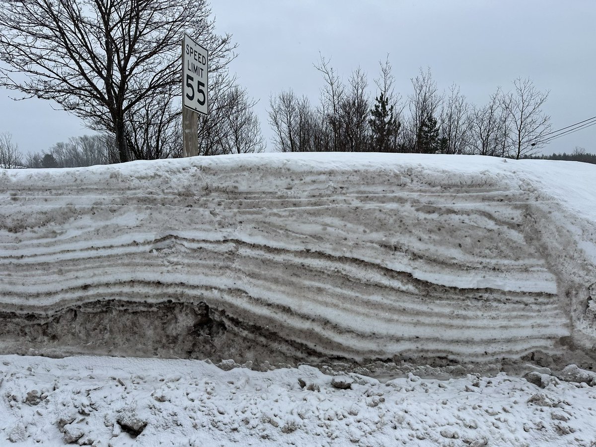
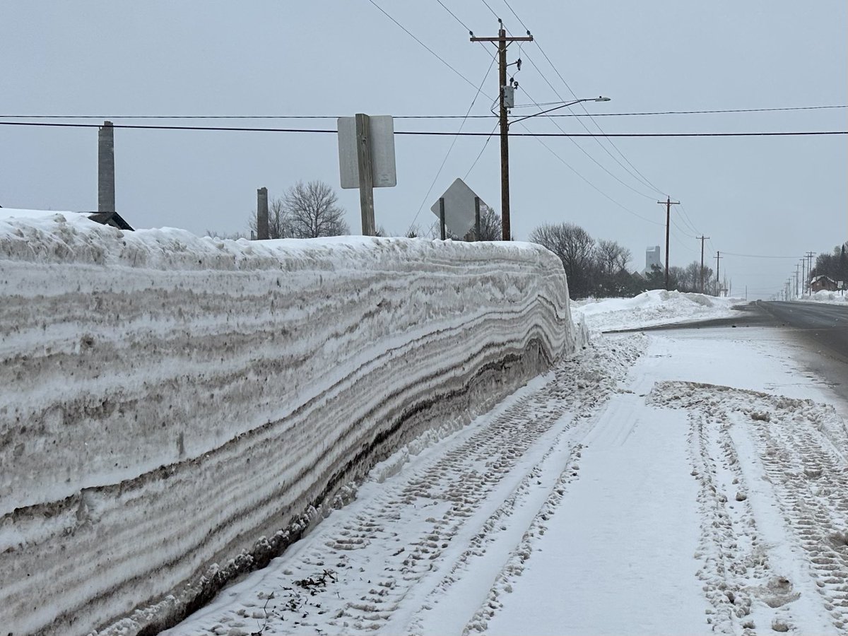
Natural data viz: Had to pull over on my way home from the gym to get some snowbank shots in my shorts.
When the machines cut into the banks it’s so cool to see every individual snowstorm as a layer demarcated by a plow line. The lower the layer the more it’s been compressed
It’s like a time-series sculpture of the season, and basically a type of Fordite (the name given to layers of alternating paint colors that can build up in painting facilities).
Almost makes me want to pick up a paint brush because this would be a fun & easy palette & constraint
Our partnership with @Esri is expanding what’s possible with parcel data!
In our latest blog, CEO @WELLO explores how Regrid & Esri are working together to go beyond traditional property boundaries.
Read now - https://t.co/RZnbHvWETZ
Detroit / Grosse Pointe border. An example of what you can do with demographic data from @Esri now available in @regridapp's nationwide parcel data:
Map shows all occupied homes (per Regrid land use and USPS vacancy data), color coded by block group level 2024 median household income from Esri Demographics.
Endless ways to be amazed by how little space separates such a distance in wealth here.
RIP David Lynch. For someone most associated with abstract storylines, he was a remarkably clear communicator about the power of ��ideas,” and philosopher of what ideas are and want to be: https://t.co/ReFL1dbSQu
Thank you for a life of saying hard to put into words things.
2024 was a big year for Regrid. From major milestones (like our partnership with @Esri!) to exciting growth, we’re looking back on everything we achieved.
Get the full story in our annual report -https://t.co/sS2ZluD66i