And people laughed bc I was quoted saying I wanted @DeshaunWatson4 to throw missiles!?! Roll tape. Doesn't get better than this! #Natty https://t.co/rniQIiaLkK
Good Friday morning! It's very important to be careful around trees and power lines with high winds occurring. Trees are continuing to come down, some on power lines. Here's a list of the highest gusts we've seen so far: https://t.co/fCnVd53vCb #scwx#gawx#caewx
DD2 is monitoring the weather. Most severe wind/rain are projected in our area early (6-7 pm) to late evening w/worst conditions north & west of us. With any changes that may impact student safety/operations, the decision to alter schedules will be made quickly & sent to all.
Parents, we will have an early release day today, after carefully monitoring the weather situation. Elementary schools will dismiss at 11:15 AM. Middle and High schools will dismiss at 12:15 PM.
Due to the threat of severe weather all DD4 schools will close early today, Thursday, Feb. 6.
Elementary schools will be released at 11:30a, Middle Schools at 12:15p, and Woodland High School will be released at 12:30p.
All after school programs have been canceled. #chswx
DD2 is on a regular schedule today. If changes occur, you will be updated through phone calls, social media, websites and local news. #TeamDorchester#dd2#dorchester
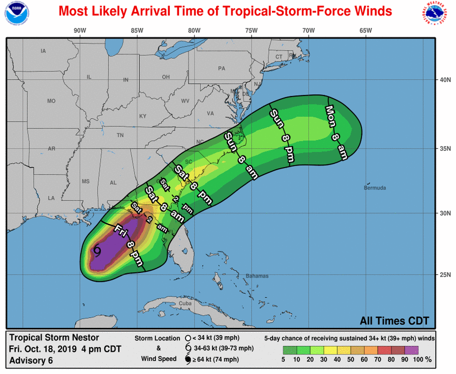
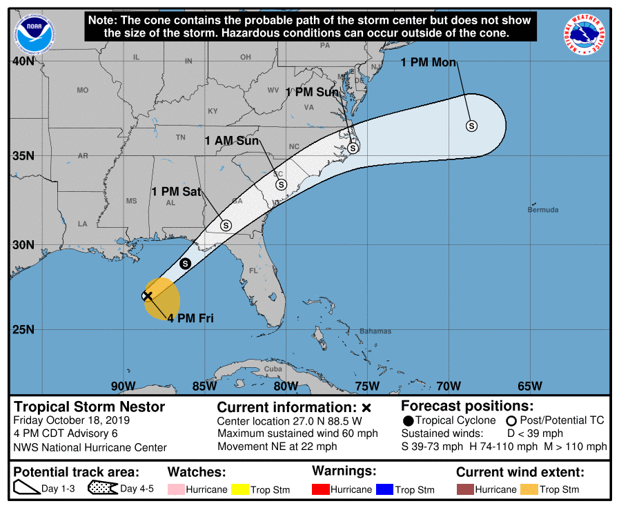
5 pm Fri...Tropical Storm Nestor was 280 mi SW of Panama City FL with max winds of 60 mph. Nestor is moving to the NE at 22 mph and will approach the FL panhandle tonight & become a post-tropical cyclone as it tracks across portions of GA & SC and off the NC coast by late Sunday.
Alligator taking a stroll down US 278 on Hilton Head Island, SC. Gator and #Dorian moving at same speed. @BMonahanWSB is tracking the storm all morning on @wsbtv.
#Dorian will bring destructive winds to eastern SC, bringing down many trees & power lines. Bigger concern is the potential for life-threatening storm surge & flash flooding. Many structures & roadways will be impacted. Water results in ~90% of direct deaths in tropical systems!
Lane reversal operations on I-26 in South Carolina will cease at noon Wednesday so that crews can seek shelter at safe locations outside of the storm’s projected path. #Dorian
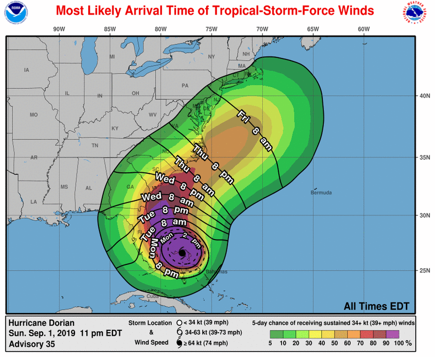
[9/3/19 7:45 PM] We will have the 8 PM #Dorian Advisory from NOAA NWS National Hurricane Center here soon. Here are current sustained tropical-storm-force wind probabilities and most likely arrival times from the 5 PM advisory. #scwx#gawx#caewx
A Tropical Storm Watch has been issued for Bamberg, Orangeburg, Clarendon and Sumter counties. The main threats to these areas are strong winds and flooding rain. Have your hurricane plan ready, stay indoors during strong winds and do not drive through flooded roadways.
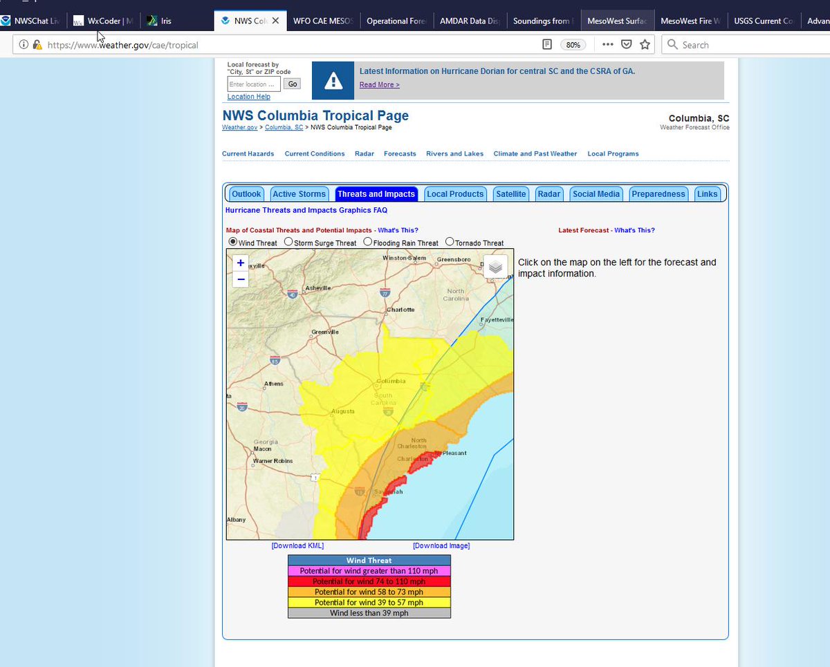
The threat of tropical storm force winds will extend inland. Those in the eastern Midlands (the areas east of the Columbia area and near I-95) have a greater risk than the central Midlands. Prepare for strong winds that begin late Wednesday.
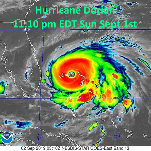
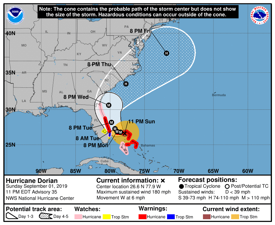
At 11 pm Dorian was 135 mi E of West Palm Beach FL moving to the west @ 6 mph with max winds of 180 mph. A slower W to WNW motion is forecast for the next day or so, then a gradual turn toward the NW, bringing Dorian dangerously close to the Florida coast late Mon thru Tue night.
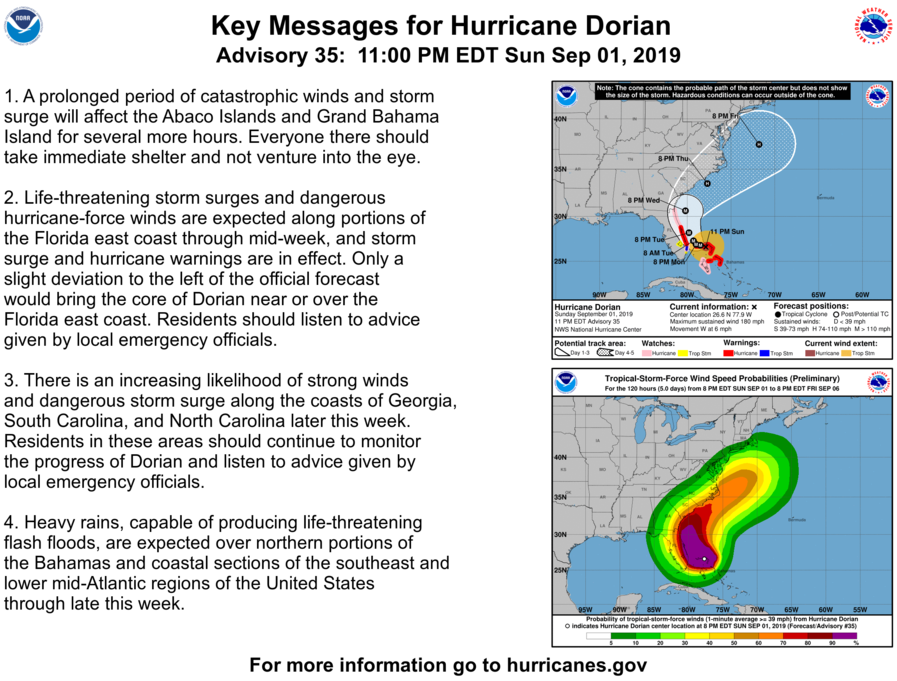
Hurricane Watches Expanded Northward Along the East Coast to the Florida/Georgia Border. Here are the 11 PM EDT 09/01 Key Messages for #Dorian. For more info see https://t.co/tW4KeFW0gB
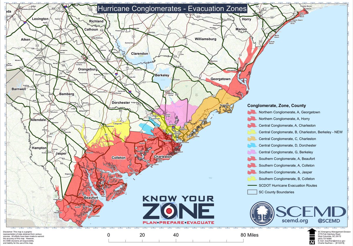
ALERT: #Dorian EVACUATION BEGINNING NOON TOMORROW, September 2, 2019: Colleton Zones A, B; Beaufort Zone A;
Jasper Zone A; Charleston Zones A, B, C; Dorchester Zone D; Berkeley Zones B, G; Horry Zone A Georgetown Zone A https://t.co/J3bs5wRCmq #sctweets#alert
Gov. Henry McMaster Orders Mandatory Evacuations for Coastal Counties Effective Tomorrow, September 2 at Noon
| Governor Also Ordered School and State Government Office Closures in Coastal Counties https://t.co/yzHoBtyLi6




![NWSColumbia's tweet photo. [9/3/19 7:45 PM] We will have the 8 PM #Dorian Advisory from NOAA NWS National Hurricane Center here soon. Here are current sustained tropical-storm-force wind probabilities and most likely arrival times from the 5 PM advisory. #scwx #gawx #caewx https://t.co/GLKcOXTIKL](https://pbs.twimg.com/media/EDk_6RbXoAICqmK.jpg)