Flooding will be a huge concern across the Pensacola area today. This is a very dangerous situation as radar indicates 12-18” of rain has fallen overnight. Be safe & avoid the high water areas.
Radar check: A thunderstorm complex continues to blossom over the Gulf. Heavy 🌧 & few strong⛈ are moving ashore near Apalachicola. Storms will shift east to the peninsula this evening. A second complex should arrive early Sunday. Hail, wind damage, & 🌪 are all possible. #FLwx
Tight rotation on radar indicates a possible tornado southwest of Bristol in the #Panhandle. If you are in the path of this storm, take cover NOW! Data suggests that a tornado is on the ground! #FLwx
Severe Thunderstorm Watch for Alachua, Baker, Bradford, Clay, Columbia, Duval, Flagler, Gilchrist, Hamilton, Marion, Nassau, Putnam, St. Johns, Suwannee and Union County in FL until 10:00pm EDT. Details on the Florida Storms app.
Severe Thunderstorm Watch for Brevard, Indian River, Lake, Martin, Okeechobee, Orange, Osceola, St. Lucie, Seminole and Volusia County until 10:00pm EDT. Details on the Florida Storms app.
Aside from the storms in the Panhandle, seabreeze thunderstorms are starting to develop over interior #NFla. Heavy rain rates are already occurring, and as these storms intensify, they could turn strong enough to produce hail or wind damage. #FLwx
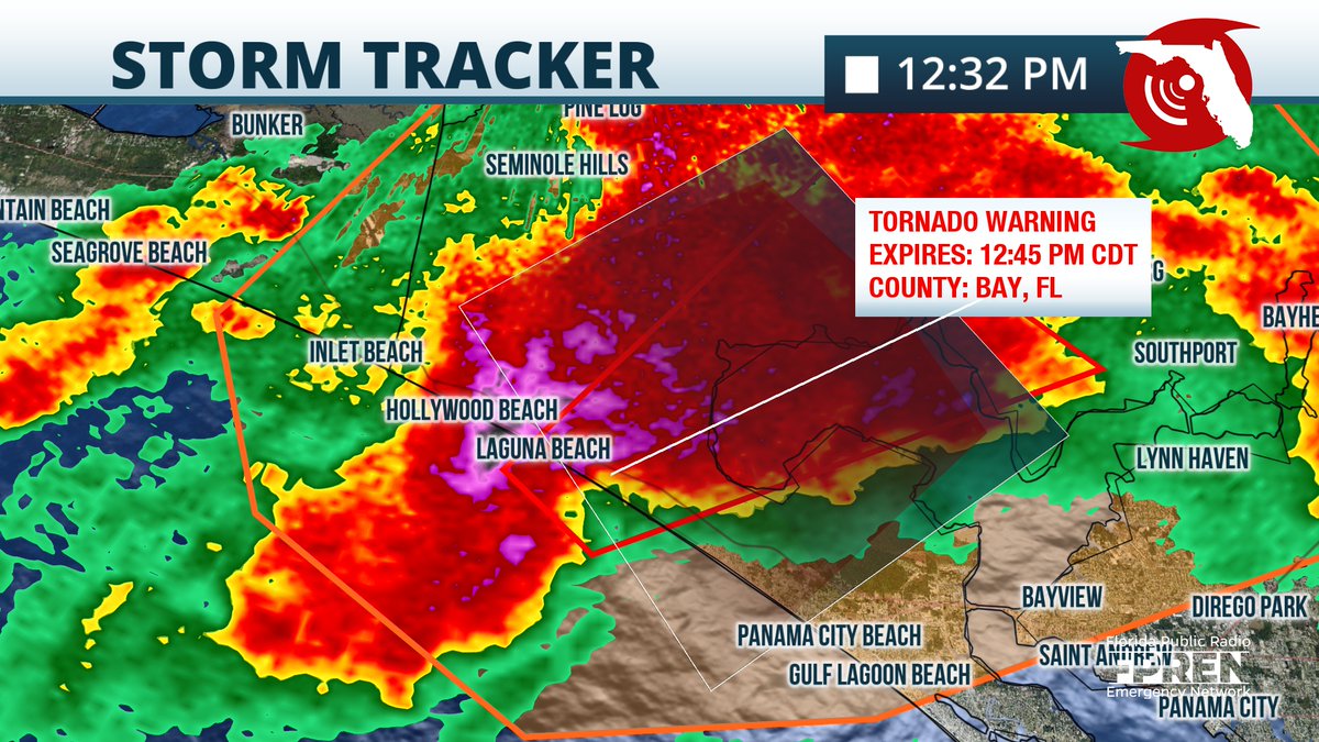
Several areas of rotation are being detected from this tornado warned storm. In addition, large hail is likely being produced by this cell. Hollywood Beach and Laguna Beach, seek shelter NOW! #FLwx