#TropicalUpdate - A strong tropical wave (the remnants of Dolly) continues to produce shower and thunderstorm activity affecting the northern Leeward Islands, the Virgin Islands and Puerto Rico, bringing beneficial rain to many drought stricken areas. While redevelopment does not seem likely over the next day or two, as the wave continues to move west-northwestward at about 25 mph, conditions may become more favorable for development as it approaches the southeastern Gulf of America/Mexico, the Bahamas and the Turks and Caicos. Interests in Florida, the Bahamas, the Turks and Caicos, Cuba and Hispaniola should monitor the progress of this wave, however as the forecast stands, nothing to be alarmed about. Get the latest on any possible changes to the forecast at https://t.co/FTuAmN2v27 and https://t.co/VLD4mJroLY.
#WeatherPrepared - What is a Invest? We currently have an INVEST or an area to investigate in the northern Gulf of America/Mexico with a 30% chance of formation over the next 7-days. But what exactly is an INVEST? It's a shortened term for "investigation", and is an area that needs to be investigated! Not all invests become tropical cyclones, but most tropical cyclones usually are invests before being designated. Get the latest on #AL97 at https://t.co/FTuAmN2v27 and https://t.co/VLD4mJroLY
#Hurricanes2026
☀️ Your U.S. Weather Synopsis for Today: Chances for isolated thunderstorms are possible across parts of the northern and central Plains, and the eastern Great Basin today. There will be a chance for occasional severe wind gusts and hail. Moisture continues to move into parts of the Western U.S. increasing shower and thunderstorm activity. Flood Watches remain in effect for parts of western Colorado, southern/eastern Utah and much of Arizona.
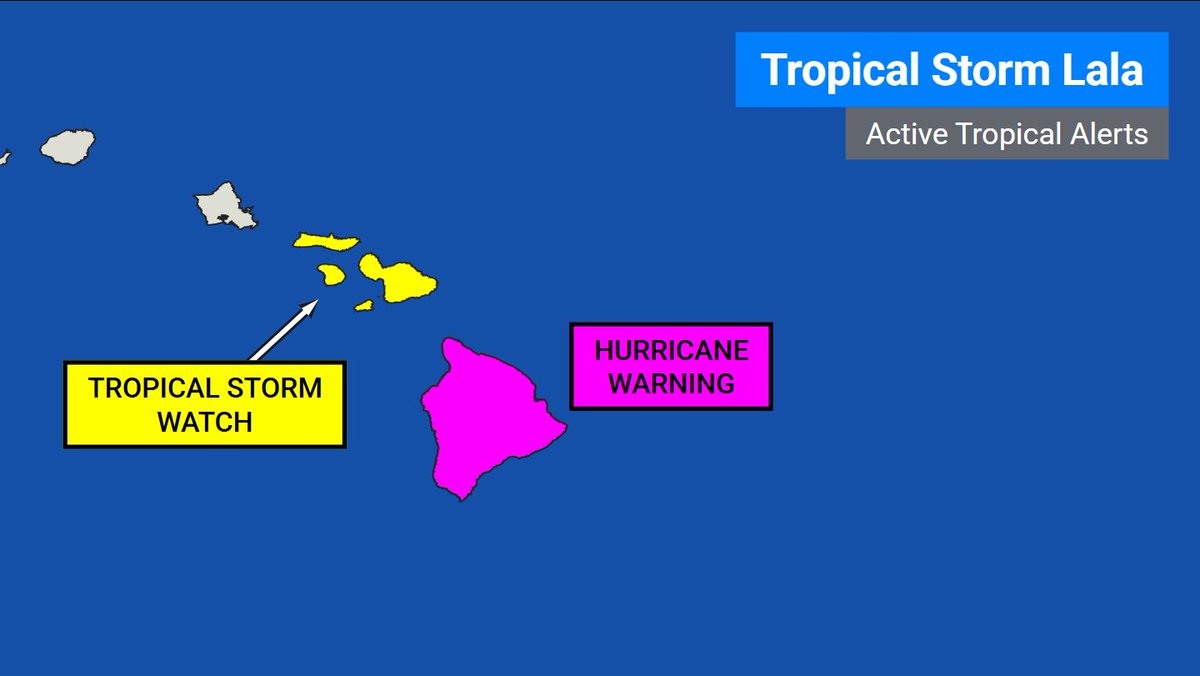
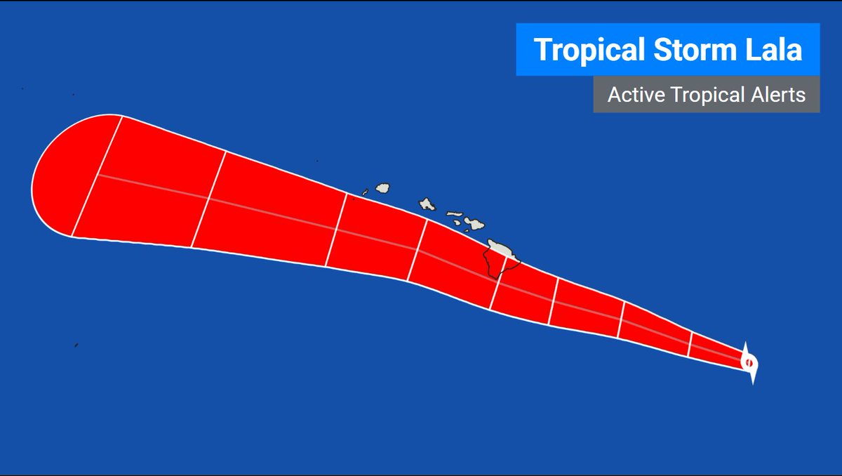
#LALA - Tropical Storm Lala's winds have increased to 60 mph, with a central pressure of 997 mb. A Hurricane Warning has been issued for the Big Island of Hawaii and Tropical Storm Watches are now in effect for Maui County including the islands of Maui, Lanai, Molokai and Kahoolawe. Lala is forecast to become a hurricane as it approches the Big Island.
With the current forecast, Lala is expected to be near the Big Island on Saturday, and pass to the south of the remaining islands later in the weekend.
Get the latest information at https://t.co/FTuAmN2v27.
Interests in the Hawaiian Islands should monitor the progress of this system, and take necessary preparatory actions! Preparations to protect life and property should be rushed to completion in the Hurricane Warning area.
#CRISTOBAL - Tropical Storm Cristobal is forecast to become a remnant low later today and dissipate. Maximum sustained winds are around 40 mph. Get the latest at https://t.co/M0uua8u2pE.
#Cristobal | We now have Tropical Storm Cristobal in the Northern Atlantic. It's not expected to do much, and is expected to devolve into a Tropical Depression tomorrow. Sustained winds are currently at 45 mph, with a central pressure of 1008 millibars. No land hazards at this time.
#BREAKING#Bertha
Tropical Depression #Two has intensified into Tropical Storm Bertha, the second named storm of the 2026 Atlanta Hurricane Season. Bertha is currently located in the northeastern Gulf of America. Get all the information on this storm, and its projected impacts at https://t.co/FTuAmN2v27.
[!] Tropical Storm and Storm Surge Watches are active for parts of the U.S. gulf coast.
#BREAKING The National Hurricane Center will be initiated advisories on newly upgraded Tropical Depression #Two (formerly #AL91) at 11:00 AM EDT. Get the latest at https://t.co/M0uua8u2pE.
🚨#BREAKING The National Hurricane Center has designated Tropical Storm #Arthur in the northwestern Gulf of America. Get the latest at https://t.co/M0uua8u2pE.
Tropical Storm #Arthur Advisory 5 (10 AM CDT, Wed Jun 17): Tropical Storm Arthur Develops Near the Middle Texas Coast. Life-Threatening Flooding Expected Across Portions of the Southeastern United States. https://t.co/tW4KeGdBFb
#TropicalUpdate#PotentialTropicalCycloneOne#One
The latest forecast cone for Potential Tropical Cyclone One as of the 1000 AM CDT updated. Tropical Storm Watches have been issued for parts of eastern Texas and western Louisiana. The system is forecast to become a tropical storm tonight/early tomorrow morning. PTC One could become a tropical depression later today.
For the latest information on PTC One, visit https://t.co/FTuAmN2v27
#TropicalUpdate
The latest Tropical Cyclone Advisory on Potential Tropical Cyclone #One in the northwestern Gulf of America (Mexico).
Synopsis: Maximum sustained winds are around 30 mph with a minimum central pressure of 1007 millibars. Currently movement is northeast at 6 mph. Widespread very heavy rainfall capable of producing life-threatening flash flooding across parts of the gulf coast. A Tropical Storm Watch has been issued for portions of Texas and Louisiana.
STORM INFORMATION
-------------------------
Potential Tropical Cyclone is currently located 65 miles southwest of Corpus Christi TX or 360 miles southwest of Lake Charles LA, moving northeast at 6 mph. The maximum sustained winds are 30 mph and the minimum central pressure is around 1007 millibars. PTC One is expected to continue moving northeast with an increase in forward speed over the next few days. The low should move offshore of the TX coast tonight or tomorrow, and will move about parallel to the gulf coast. The system will then move back inland in either extreme eastern TX or southwestern LA late Wednesday or Thursday.
While PTC One is offshore, gradual strengthening is possible, and the system could become a tropical storm early tomorrow. Weakening is then expected on Thursday as the storm makes landfall. If the system becomes a tropical storm, it would become the first named storm of the 2026 Atlantic Hurricane Season (Arthur).
WATCHES AND WARNINGS
------------------------------
A Tropical Storm Watch has been issued for the northwestern Gulf Coast from Sargent Texas to Morgan City Louisiana. A Tropical Storm Watch means that tropical storm conditions are possible within the watch area within 24 to 36 hours.
HAZARDS TO LAND AREAS
------------------------------
The biggest threat will be life-threatening rainfall. Rainfall totals around 4-8 inches with higher totals around 12 inches possible through Thursday from the mid/upper TX coast through much of LA/MS/AL and the far western FL panhandle. Life-threatening flash, urban and river flooding will be possible. Tropical storm conditions are also possible within the watch areas, beginning early Wednesday.
Storm surge will also be possible, with Port Bolivar TX to Morgan City LA possibly receiving 2-4 of surge if peak surge occurs during the time of high tide.
FOR THE LATEST INFORMATION ON POTENTIAL TROPICAL CYCLONE #ONE, VISIT https://t.co/6TQiIHP9lo
NEXT ADVISORY WILL BE ISSUED AT 100 PM CDT.
Potential Tropical Cyclone #One Advisory 1 (10 AM CDT, Tue Jun 16): Very Heavy Rainfall and Dangerous Flash Flooding Expected from Potential Tropical Cyclone One. https://t.co/tW4KeGdBFb
#BREAKING: The National Hurricane Center will be issuing advisories on Potential Tropical Cyclone #One at 11:00 AM EDT/10:00 AM CDT. https://t.co/M0uua8u2pE
The National Hurricane Center has given our area of interest in the northwestern Gulf the "Invest" designation, specifically Invest 90L. But...what exactly is an invest? See our graphic below!
An Invest is an area being "investigated" for potential development. When a system is given this tag, special computer models are being ran on the storm to predict its development and track, and sometimes hurricane hunter aircraft are dispatched to locate it's center and gather critical data about the storm. Most storms start out as a "invest" before getting a name! Get the latest on this one at https://t.co/FTuAmN2v27
#WeatherPrepared #TropicalUpdate #Invest90L
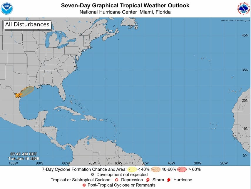
8:40 AM ET - The latest tropical weather outlook for the Atlantic. We have a tropical disturbance in the northwest gulf with a 60% (🍊 medium) chance of becoming a tropical depression/storm over the next 48 hours. A low currently over south Texas will move northeast today along the coast, and eventually emerge over the northwestern Gulf of America today or tonight. The system could become a storm later today or tomorrow, especially if the system can get far enough offshore. Tropical Storm Watches or Warnings may be required later today for parts of the gulf coast and marine areas. https://t.co/CLIOhiiwKb
#tropicalupdate #tropics #weather
An area of low pressure continues to spin inland over south Texas producing a wide area of showers and thunderstorms. The low is expected to move northeast along the Texas gulf coast and could re-emerge over the northwestern Gulf later today or tonight. There is a medium (60%) chance the system develops into a tropical depression or storm in the next 48 hours.
Conditions will be marginally favorable for development of the system, and a short-lived tropical depression/storm is possible late today or Wednesday, especially if the system moves far enough offshore. Regardless of the development, widespread intense rainfall is expected over the next several days across portions of eastern/southern Texas, and parts of Louisiana and Mississippi. The potential exists for life-threatening flash, river and urban area flooding.
Get the latest information on this system at https://t.co/CLIOhiiwKb
Interests along the gulf coast should monitor the progress of this system. Tropical Storm Watches or Warnings may be required for some locations later today.
#tropics #tropicalupdate #weather
#WeatherHistory
15 years ago, April 25th to 28th 2011, a prolific tornado outbreak unfolded across the south, midwest and northeast, with the biggest and deadliest day on April 27th 2011. A total of 224 tornadoes touched down on this day alone, with 4 being rated EF-4. This outbreak became known as the "2011 Super Outbreak", and was the largest and costliest tornado outbreak ever recorded.
As severe weather is once again likely today, we urge you to be weather prepared. Have multiple ways to receive life-saving weather alerts from the National Weather Service.
#WeatherPrepared
16 years ago today, Deepwater Horizon, an offshore drilling platform around 41 miles off the coast of Louisiana, catastrophically exploded on the Gulf of Mexico (America), releasing 134 million gallons of crude oil into the water, creating the largest marine oil spill in U.S. history. Impacts are still seen in coastal areas to this day.
Here is an article from NOAA about Deepwater Horizon and its lasting impacts: https://t.co/oBZTYVVF2Q
Image Credit: National Geographic (https://t.co/tCUbmqJHdk)
#DeepwaterHorizon #environment








![WWSUSA's tweet photo. #BREAKING #Bertha
Tropical Depression #Two has intensified into Tropical Storm Bertha, the second named storm of the 2026 Atlanta Hurricane Season. Bertha is currently located in the northeastern Gulf of America. Get all the information on this storm, and its projected impacts at https://t.co/FTuAmN2v27.
[!] Tropical Storm and Storm Surge Watches are active for parts of the U.S. gulf coast.](https://pbs.twimg.com/media/HNtjImnXAAAL6zE.jpg)