Precision Analysis. Real-Time Action. 🇪🇺 High-resolution meteorological breakdowns for the European continent. We watch the models. You get the action.
There’s a hidden threat building over Europe right now that isn't getting enough attention.
The 'Spanish Plume' is pushing Precipitable Water (PWAT) values to extreme highs. If storms trigger in this airmass, the risk of severe flash flooding will escalate rapidly. Be wary!
HEATWAVE UPDATE: A Spanish plume will bring increasingly intense heat to much of Europe this week. Widespread 30°C+ is expected, with isolated peaks near 40°C. Take precautions to avoid heat stress and related impacts. #heat#heatwave#europe
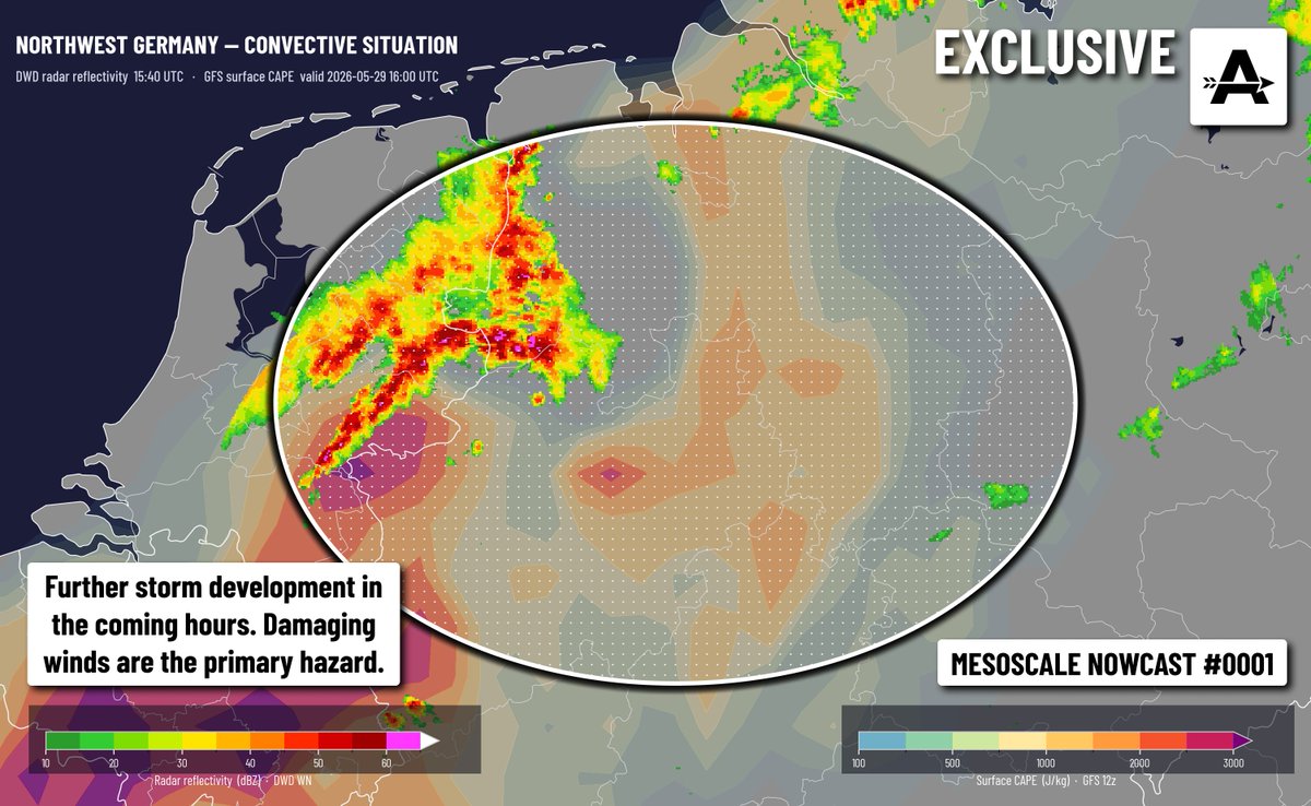
⚠️ MESOSCALE NOWCAST:
Scattered supercell and multicell storms are possible over the next few hours along a convergence line across parts of the Balkans.
Large hail and damaging winds are possible, an isolated tornado risk exists. #storms#europe#forecast
HEATWAVE UPDATE: Late next week, a Spanish plume will bring intense heat to much of Europe. Widespread 30°C+ is expected, with isolated peaks near 40°C. Take precautions to avoid heat stress and related impacts. #heat#heatwave#europe
⛈️ Multiple supercells are actively ongoing in northwestern Romania right now. Some of these are presenting significant rotation at times, and the risk of a tornado and large hail is present. Stay aware! #Romania#storms#tornado#hail
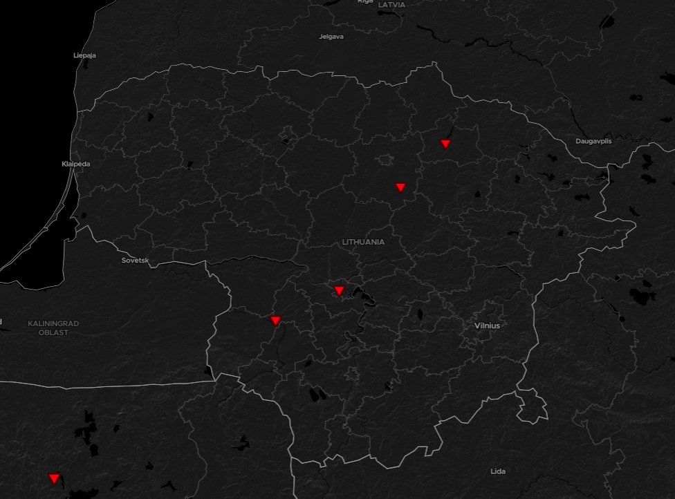
Severe weather threat ramping up over Lithuania with a clear supercell moving towards environment of strong low-level shear. Tornado and severe wind gust risk are going to increase through 15 UTC.
🔴Tomorrow's weather could become severe across the eastern half of the Baltic countries. Strong wind gusts, large hail and tornadoes are possible as an active weather system moves through the region. #storms#europe#weather
🌪️Tornado Outbreak in Lithuania
On June 5, at least 4 confirmed tornadoes across the country occured. The strongest tornado - an IF2 over Kaunas - ripped off roofs and leveled trees. A tornado also occured in Poland. More details soon. #tornado#lithuania#poland
🔴 NORTHERN ITALY SEVERE STORMS: Significant severe weather potential is in place in a highly unstable environment tomorrow, with the potential of multiple supercells causing (very) large hail and damaging wind gusts. A tornado cannot be ruled out! #Italy#Storms#Tornado
🌪️POLAND IF2 TORNADO: Here is an animation of the radar and synoptic environment of the Balcarzowice tornado that occured yesterday. Note the tracker is a bit lost at the start. The tornado caused fairly significant damage in its short track.
⚡LATEST: A complex of intense storms that just moved through the Netherlands will continue to move across Germany, bringing the risk of damaging winds (90-120km/h) and large hail. Further storm development is also expected. #wxtwitter#severewx#EUwx
🚨SEVERE WEATHER across EUROPE today. Storms firing along a cold front, expect LARGE HAIL (2 inches / 5 cm) and DAMAGING WINDS 90-110 km/h. Low tornado risk but stay alert. #wxtwitter#severewx#EUwx
🚨 Europe Weather Alert: A dangerous late May #heatwave is hitting Southern & Western Europe. Temps in #Spain, #France, and #Portugal will exceed 35°C, potentially soaring to 39°C. We could see records broken due to this extreme heat. Stay safe and hydrated! ☀️🌡️ #Europe#Heat
⚡CONVECTIVE OUTLOOK: Severe thunderstorms are most likely in Germany, Austria and Czechia and possible from the Mediterranean Sea to Belarus. Large hail and damaging winds are the primary hazards, though an isolated tornado cannot be ruled out. #europe#thunderstorms#weather
⚡CONVECTIVE OUTLOOK: Severe thunderstorms are possible across France, Spain, Turkey, the Netherlands, northern Germany and southern Denmark on May 3rd. Watch out for large hail as well as isolated damaging winds and tornadoes. #europe#thunderstorms#weather
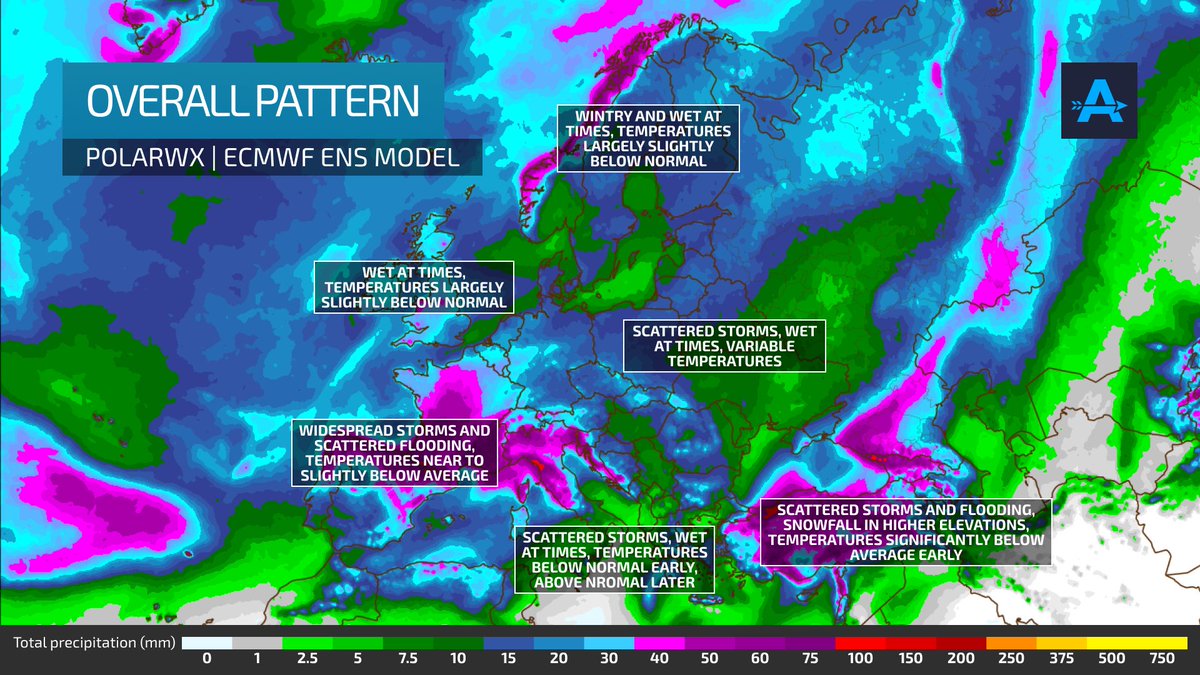
📅10 DAY OUTLOOK:
- Scattered storms and flooding across much of Europe, widespread storms in Western Europe
- Wintry in Scandinavia
- Snow in higher elevations in Turkiye
- Tons of rain in Norway
Check out our graphic for details!
#weather#europe#storms
💨THE POWER OF A COLD FRONT: A massive cold front with gusts hitting 90km/h is currently sweeping across southern Ukraine, kicking up a dust storm visible from space. A stark reminder of how weather and landscape change collide. #Weather#Europe#Dust#Ukraine
🚧SPLIT PATTERN: Check this out! We are seeing an impressive temperature contrast, with snow and wintery conditions returning to the Baltic countries and even further south, while Western Europe stays warmer than normal with some thunderstorm activity. #weather#europe
❄️WINTER'S LAST HURRAH?
Over the next few days Eastern Europe will be getting impacted by a low pressure area. Not only will it potentially bring storm force gusts in places, but some snow and sleet also. Blizzard conditions are possible in Russia. #europe#weather#snow