Partly cloudy skies and drier conditions overall today and Tuesday as high pressure moves into the region. Showers and thunderstorms could occur Wednesday afternoon and evening primarily east of I-81 ahead of a strong cold front that will transition into the region Thursday.
1:52pm- Continue to watch radar this afternoon as a strong front moves toward the region. The front will bring two rounds of scattered severe t-storms capable of producing damaging winds, localized urban flooding (4-10pm), and a brief tornado also cannot ruled out (I-95 eastward)
Drier conditions on Saturday as high pressure moves into the Mid-Atlantic. Severe thunderstorm chances return on Sunday with an incoming cold front from the northwest. Somewhat cooler temperatures and mostly cloudy conditions are expected Monday.
Another day of showers and thunderstorms. Some storms can be severe this afternoon and evening, with the higher probabilities of damaging winds generally along and east of the Blue Ridge.
Strong to severe thunderstorms remain possible today and Friday amid a hot, humid, and unstable atmosphere. Heavy rain, gusty winds, and isolated hail are possible during the afternoon & evening hours. Additionally, heat indices of 100º to 105º F are possible. Drier Saturday.
Daily t-storm chances begin today w/ severe t-storms possible in the afternoon & evening through Friday. Heat & humidity also increase, with a major heat risk Thursday afternoon & Friday afternoon.
Heat continues today. With the heat comes a Slight Risk (level 2 out of 5) for severe t'storms late afternoon/evening near/north of I-68/I-70; main threat is damaging wind gusts. #DCwx#MDwx#VAwx#WVwx
Hot weather will continue through the weekend. A few showers and perhaps a couple of strong thunderstorms may affect mainly northern MD into eastern WV late Saturday.
Dry and sunny through the weekend with temperatures ranging from the 50s overnight to the 70s during the day. Today will be breezy, with wind gusts between 20-25 mph throughout the day before gradually calming in the evening.
A strong cold front will cross the area today bringing multiple rounds of strong to severe thunderstorms. Localized flooding and damaging winds cannot be ruled out with storms today. Turning drier and cooler behind the front Thursday into the weekend.
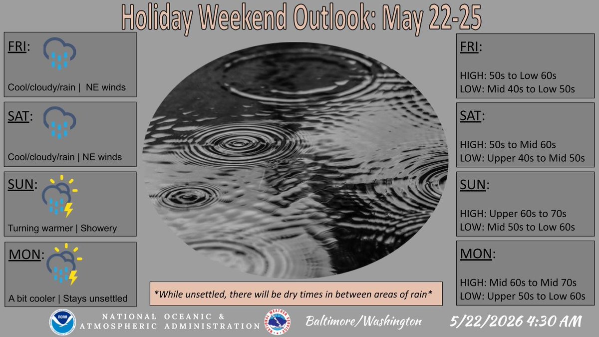
Wet and cool conditions expected across the area through Saturday, with periods of moderate rain at times. A bit drier, warmer on Sunday, then shower and thunderstorm chances persist into early next week.
A 20 to 30 degree drop in temps today with on & off rain chances continuing into the weekend ahead. Expect highs for most in the 60s over the next couple of days with overnight lows in the 40s & 50s. Highest rain chances are on Friday & Saturday. More: https://t.co/5RyZgpeTAT
A strong cold front will bring scattered strong to severe t-storms to the region this afternoon & evening, ending the record breaking heat. Expect a 20-30 degree temperature drop Thursday, with additional rain chances lingering into the weekend. More: https://t.co/5RyZgpeTAT.
Record high temps are expected to continue through Wednesday. A strong cold front will cross the area Wednesday afternoon into Thursday AM bringing strong to severe t-storms. Additional rain chances & a 30 degree drop in temps is expected late week. More: https://t.co/5RyZgpeTAT
Warming temps & spotty shower/t-storm chances can be expected this weekend. Highest confidence for showers/t-storms today & Sunday will mainly occur west of the I-95 metros. Highs today push into the upper 70s & mid 80s with many locations near 90 Sunday. Even hotter Monday.