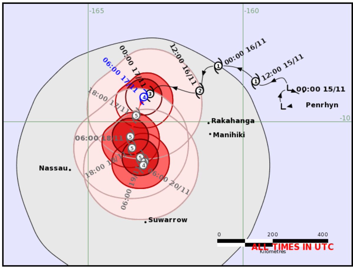
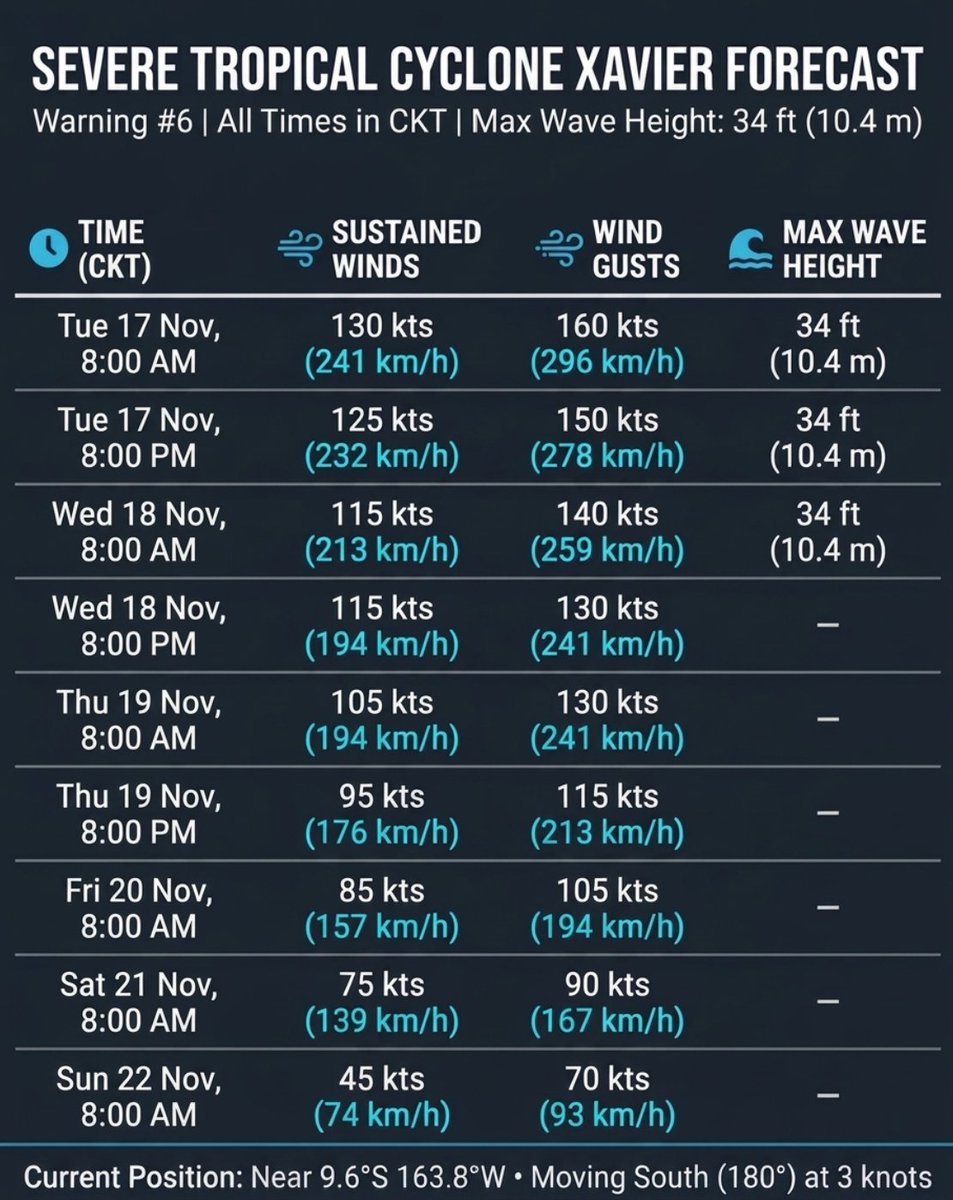
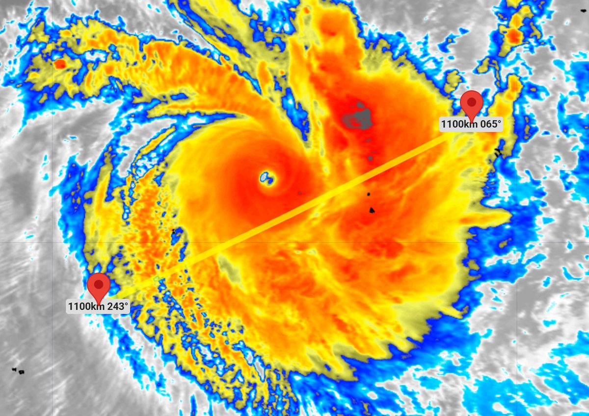
🌀🚶🏽Moving just 65 km in 12 hrs, #CycloneXavier is basically moving at the same speed as a human briskly walking. (This increases rainfall & wave heights).
#XAVIER is trapped with no where to move - and will gradually start weakening now. Still Category 5 at the moment though.
Same information as above, but this is all converted to Cook Islands Time (due to the time zone full day difference between NZ and Cook Islands it can get quite confusing!).
⚡️Low pressure at the top of NZ, colder air in the south of NZ and voila - we have some thunderstorms:
📡View FREE: https://t.co/SfmSWOMdlX
📲Upgrade to get the Live NZ Lightning Tracker and real time push notifications when lightning is near you: https://t.co/oGjZwE35sx
📺🦘🚨⚡️⚡️⛈️🌦️🌡️📈📉💨#Australia: Severe Thunderstorms, downpours, tracking east - a cold wintry/spring blast for Tas & Vic in particular on Monday next week: https://t.co/c3VxdorkPk via @YouTube
Weather nerds already know this, but many people find it confusing that global maps (Such as Google's DeepMind) show US/global categories, not our localised ones.
So we made this to help you make sense of it all. (Full explanation in our #Xavier update out soon too).
@Otway_Ranges_ Yeah I know there have been similar complaints in NZ about heat warnings for relatively low heat. I warn for over 40 as excessive heat in Australia (but also for 35+ if in any main centres)
Hey John - "Severe" is what all Southern Hemisphere Cyclones are called once they reach Category 3 and above. In the Northern Hem they use "Major" for Cat 3 and above.
With BOM, they also use "Severe" for certain thunderstorms (flash flood and damaging hail risks) and also severe heat (usually 40C and above - no matter which country on earth you live and how normal it might be to locals). All of these are global industry standards you'll find in all western nations.
🚨🌀#SouthPacific: Severe Tropical Cyclone #XAVIER becomes the first Category 5⃣ tropical cyclone of the season in the northern Cook Islands. (The season only officially started 18 days ago).
🚨🌀#Developing: Tropical #CycloneXavier now Category 4, and looks likely to become the first Category 5 cyclone of the season.
🧭The tracking, for now, keeps it mostly away from populated places - before hopefully running into unfavourable conditions and being ripped apart.
📺🦘🚨⚡️⚡️⚡️⛈️🌡️📉🌦️🌤️#Australia: Severe Thunderstorm Outbreak on the way, moving from WA to Qld, NSW and Vic in the days ahead... with a wintry blast in the south-east looking possible on Monday next week https://t.co/gLqWYj1Cg1 via @YouTube
@elioeFIN We use The Weather Company data for our NZ forecasts - they have the globe's most accurate weather data for close to a decade now.
We don't use FMS forecasts, only their tracking maps - which as you point out aren't always the best.
🌀🚨Cyclone #XAVIER is now a Severe Category 3 tropical cyclone near the northern Cook Islands. It may reach Category 4.
Official tracking: https://t.co/WUejuxtIzB