Multiple heatwaves imminent for most of #aus for next 7 days including #Sydney
With temps reaching the low-mid 30s from Thurs, Syd is staring right at its hottest ever March
Syd currently averaging just below 29C this March (daily max. temp.) Its hottest March = 27.1C (2006)
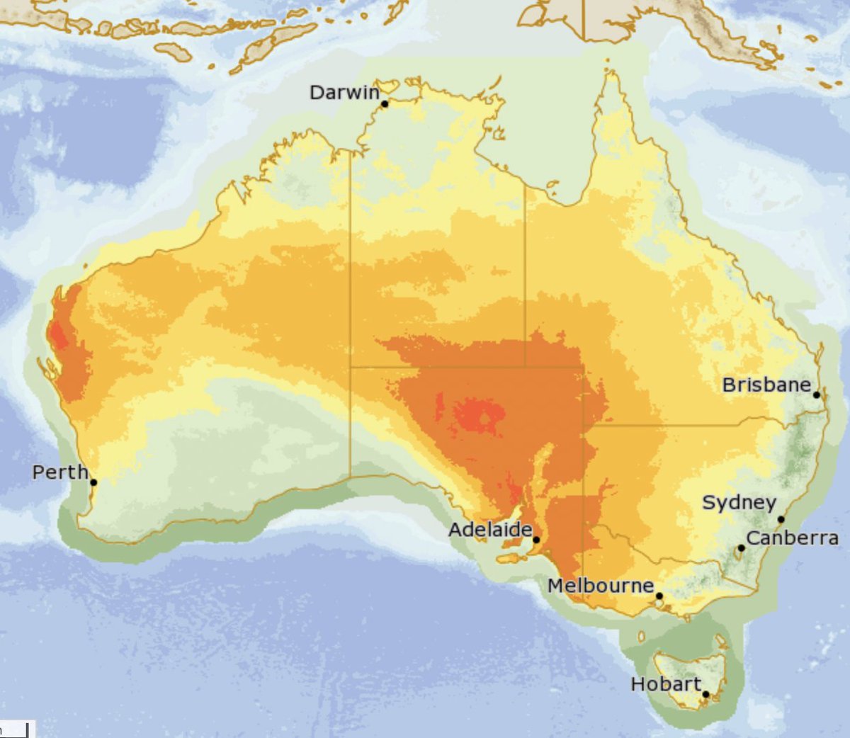
High temperatures are forecast for most of the country in coming days as heat builds across Western Australia before sweeping into eastern and southern Australia.
Latest: https://t.co/kuyJxBYtTH
The @BOM_au has officially declared the end of the 2022/23 La Niña in the Pacific Ocean.
Remarkably, the Bureau has shifted to El Niño Watch (50% likely to develop) in today's Climate Driver update.
El Niño increases the chances of a drier & warmer than average winter-spring.
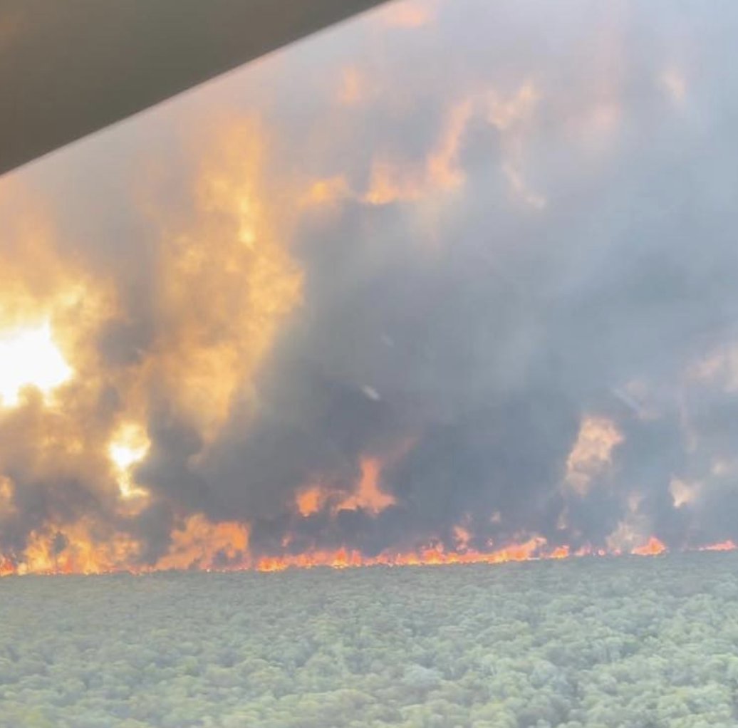
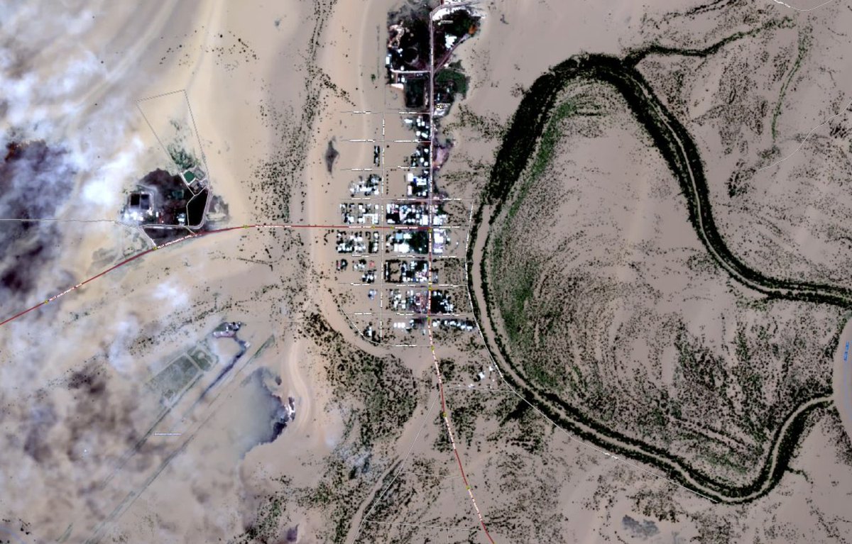
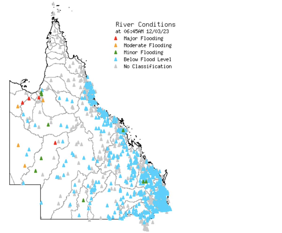
Major Flooding is occurring at Burketown #QLD, with river levels exceeding the March 2011 record flood level of 6.78 metres.
Burke Shire Council issued an Emergency Alert to residents on the weekend advising "that all remaining residents should leave Burketown immediately".
⚠️ Major Flood Warnings are current for the Nicholson, Gregory, Leichardt and lower Flinders Rivers in northwestern #Queensland - all observing record river level rises.
(Image: #bureauofmeteorology)
@NOAA (National Oceanic and Atmospheric Administration - US) & @JMA_bousai (Japan Meteorological Agency) have both declared an end to the 2022/23 La Niña in the Pacific Ocean.
The Bureau of Meteorology is expected to do the same on Tues + potentially issuing an El Niño Watch.
Temps up to 12C above average Mon/Tue across N&E #NSW - 38C for #sydney Mon - hottest day in 2+yrs.
⚠️ Fire Warnings are current for Greater Hunter, Central Ranges & Lower Western Plains - 33 schools closed.
⚠️ Heatwave Warnings current in NSW - severe across Mid-North Coast
#Sydney is looking at its hottest days since January 2021 this coming Mon and Tues, with 36C and 34C forecast respectively.
That's after a top temp. of just 30.6C during the 2022/23 #summer.
⚠️ Major Flood Warning is current for the Victoria River in the #NorthernTerritory
⚠️ Flood Watches also issued in the NT
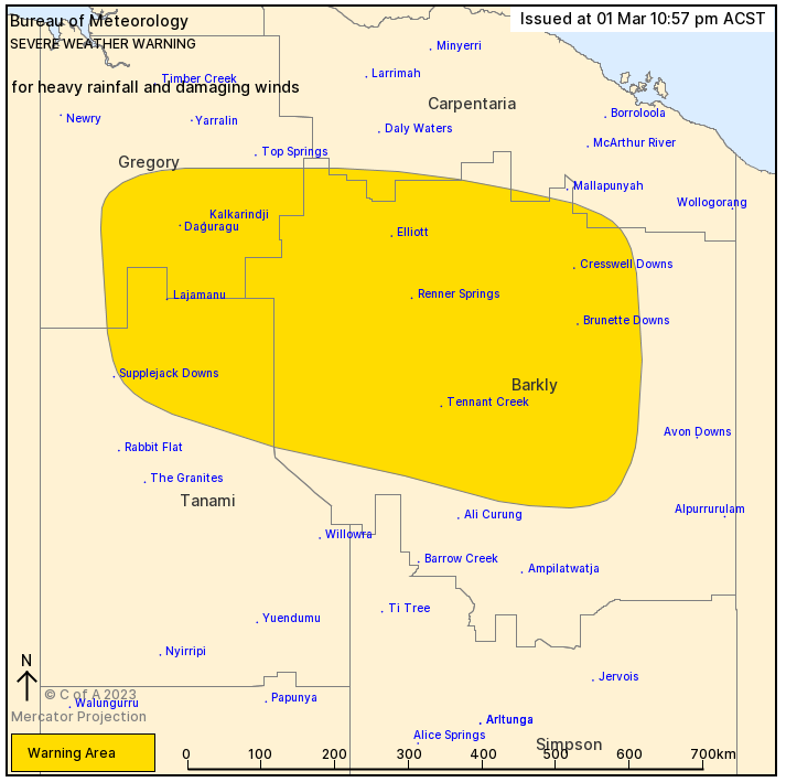
⚠️ Severe Weather Warning for Heavy Rainfall & Damaging winds also current in the NT
Hundreds of residents have been evacuated: https://t.co/hroajwjGYA
⚠️ Severe Weather Warning has been updated for central parts of the #NorthernTerritory. Heavy rainfall expected to continue within the warning area and a risk of damaging wind gusts. Further details at: https://t.co/ZubWRO9Bfl
Cool end to summer/start of autumn for #victoria, #sa and #tasmania thanks to slow-moving high pressure system.
Max temps 2-8C below average for remainder of the week. #Melbourne no warmer than 20C for the week.
#WA heatwave conditions continue with warnings likely.
Contrasting weather is forecast for the country as we head into the weekend.
Heatwave conditions are easing in the south after temperatures reached the mid 40s across WA and SA this week.
In the north of Aus, an active monsoon has re-developed.
Latest: https://t.co/gNS4KSKHi2
Hot and dry weather continues in #SouthAustralia today. Temps reaching the low to mid 40s across the state.
#Adelaide just 29.8C this morning before a top of 40C
⚠️ Heatwave Warnings current in SA
Cool change on the way for #SA today and #victoria tomorrow
(Image: BoM)
Heat returning to #victoria by mid-week.
Temperatures set to reach the mid to high 30s in #Melbourne and low 40s in the northwest of the state by Thursday or Friday.
Heatwave conditions are occurring across #victoria and southern and inland #newsouthwales.
Up to 35C today and tomorrow in #melbourne and much higher into the 40s in regional areas for several days.
Stay up to date with WillyWeather: https://t.co/eyOQiMwPDN
The latest climate driver update (CDU) from #BureauofMeteorology on Tues indicates that La Nina is ongoing, but weakening
La Nina increases the chances of above average rainfall in eastern #aus - mostly #QLD & #NSW coast 🌧️
CDU is updated every second Tues - all 👀 on the next
While #LaNiña oceanic indicators have weakened to ENSO-neutral values, the atmosphere remains La Niña-like. Climate influences including La Niña and the MJO are contributing to current conditions and the long-range forecast. Learn more: https://t.co/FMwRFTEnCH
A tropical low over the Coral Sea is being monitored off the #Qld coast. It's not a tropical cyclone yet but is likely to strengthen into a #tropicalcyclone late Wednesday or early Thursday.
https://t.co/mpgXa68yR1
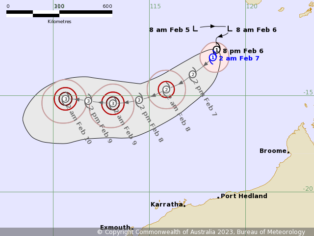
The first of three tropical lows in Australian waters has developed into #cyclone strength off the coast of #WA.
Importantly, no impact on the mainland is expected.
Tropical Cyclone Freddy lies well north of Western Australia and poses no threat to the Western Australian coast. #CycloneFreddy https://t.co/B1MVXBHUfh
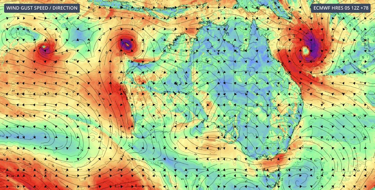
The Bureau of Meteorology is currently tracking three tropical systems offshore: one in the north Coral Sea near #QLD, and another two in the #IndianOcean near Cocos Islands and north of #WA.
They all may concurrently develop into #tropicalcyclones.
(Image: Weatherzone)