[5:30PM] - The snowfall forecast for tonight into Thursday morning remain mostly unchanged from my earlier update today (aside from a slight wobble back to the west). The heaviest snow is expected to fall between 2am tonight and 8am Thursday morning. #wiwx
Here is your updated snowfall forecast for this tonight and Thursday morning across Wisconsin. There has been a notable shift eastwards in some of the models, but there is still some uncertainty in the placement of the heaviest band of snow. #wiwx
I don't normally share these, but the SPC has outlined areas in central and northern Wisconsin for the potential of freezing rain and freezing rain thunderstorms late this evening and overnight. The full technical discussion can be read here: https://t.co/4gVkHjkWhS
A potent storm system begins to track into the region tonight, with multiple precipitation types expected for many over the next couple days. MOREDETAILS ➡️ https://t.co/Pw4IJkLn0G #wiwx
MKX issues Severe Thunderstorm Warning [wind: 60 MPH (RADAR INDICATED), hail: 1.00 IN (RADAR INDICATED)] for Columbia, Dodge, Fond du Lac, Green Lake [WI] till 6:30 PM CST https://t.co/4ZehDgGtYK
[5:30pm] - Widespread light to moderate rain is occurring across much of central Wisconsin early this evening, with more vigorous storm development ongoing across Iowa. These storms developing in Iowa will provide the primary severe risk to Wisconsin later this evening. #wiwx
The main risk currently appears to be damaging winds, but a few instances of large hail and a brief spin up tornado or two will be possible. Additionally, these storms will be producing very heavy rainfall on a mostly frozen ground, likely leading to widespread ponding of water.
Severe thunderstorms are possible this evening across central and southern Wisconsin, where a slight (level 2 out of 5) risk of severe weather has been issued by the Storm Prediction Center. #wiwx
Many roadways are being reported as ice covered across north-central and northwestern WI. Avoid unnecessary travel in these areas today! Expect some improvement of travel conditions across central WI throughout the morning as temperatures continue to rise above freezing. #WIwx
An ice storms is expected to impact portions of Wisconsin late tonight into Saturday. Travel will be extremely dangerous to impossible at times across portions of northern and central WI early Saturday morning through Sunday morning. MORE DETAILS ➡️ https://t.co/pIfLGCdOP6 #wiwx
Light to moderate snow is expected this afternoon and evening across much of Wisconsin. Widespread totals of 1-3 inches are forecast, with lower totals expected far north and higher totals near Lake Michigan. #wiwx
Travel continues to be reported as hazardous across almost the entire state. However, the precipitation is beginning to push out to the northeast, providing road crews better conditions to work it. However, snow showers and blowing/drifting of snow are likely this evening. #wiwx
[11:00am 02/22/22] Travel conditions continue to worsen across Wisconsin as the next area of precipitation pushes into western Wisconsin. Avoid unnecessary travel across the state today. #wiwx
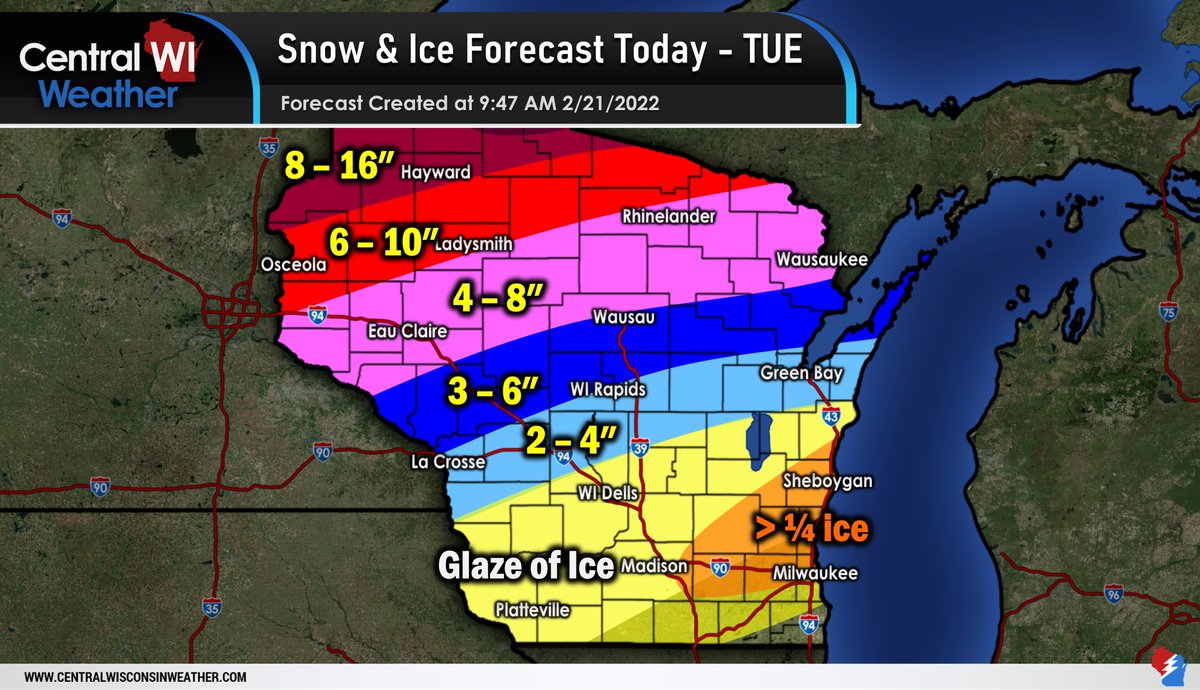
A winter storm is still expected to impact all of Wisconsin on Tuesday, with freezing rain south, a mix central, and all snow north. Travel will be treacherous and dangerous at times on Tuesday. Consider cancelling all unnecessary travel plans for the day Tuesday. #wiwx
Here is your updated storm total snowfall and ice forecast (this does include the snow that has already fallen across far northwestern Wisconsin). However, the majority of this precipitation is expected late Monday evening through Tuesday evening. #wiwx
A winter storm is expected to bring *multiple rounds* of precipitation to Wisconsin beginning Monday morning and lasting into late Tuesday night. Travel is expected to0 be hazardous, especially Monday afternoon through Tuesday night. https://t.co/RhIQ2diL5z #wiwx
A significant winter storm is expected to impact Wisconsin Monday morning through late Tuesday night. Travel will be hazardous to dangerous at times Monday through Wednesday morning. https://t.co/fBtdMhy3RJ #wiwx
A winter storm is expected to bring *multiple rounds* of precipitation to the state Monday and Tuesday. The greatest chance of notable snowfall accumulations currently appears to be centered over the northern half of the state. https://t.co/CaJXrJUcGL #wiwx


![WisconsinWx's tweet photo. [5:30PM] - The snowfall forecast for tonight into Thursday morning remain mostly unchanged from my earlier update today (aside from a slight wobble back to the west). The heaviest snow is expected to fall between 2am tonight and 8am Thursday morning. #wiwx https://t.co/69cYlXKPj9](https://pbs.twimg.com/media/FPIaMo5WQA4qR1T.jpg)


![iembot_mkx's tweet photo. MKX issues Severe Thunderstorm Warning [wind: 60 MPH (RADAR INDICATED), hail: 1.00 IN (RADAR INDICATED)] for Columbia, Dodge, Fond du Lac, Green Lake [WI] till 6:30 PM CST https://t.co/4ZehDgGtYK https://t.co/dyZnMrhOUy](https://pbs.twimg.com/media/FNH4TmzUYAA_T13.jpg)
![WisconsinWx's tweet photo. [5:30pm] - Widespread light to moderate rain is occurring across much of central Wisconsin early this evening, with more vigorous storm development ongoing across Iowa. These storms developing in Iowa will provide the primary severe risk to Wisconsin later this evening. #wiwx https://t.co/pLsiWlwC0c](https://pbs.twimg.com/media/FNH4ryFXMAAdJ3f.jpg)


![WisconsinWx's tweet photo. [11:00am 02/22/22] Travel conditions continue to worsen across Wisconsin as the next area of precipitation pushes into western Wisconsin. Avoid unnecessary travel across the state today. #wiwx https://t.co/t4ToYNUAQn](https://pbs.twimg.com/media/FMN2YP_XoBU37IF.jpg)