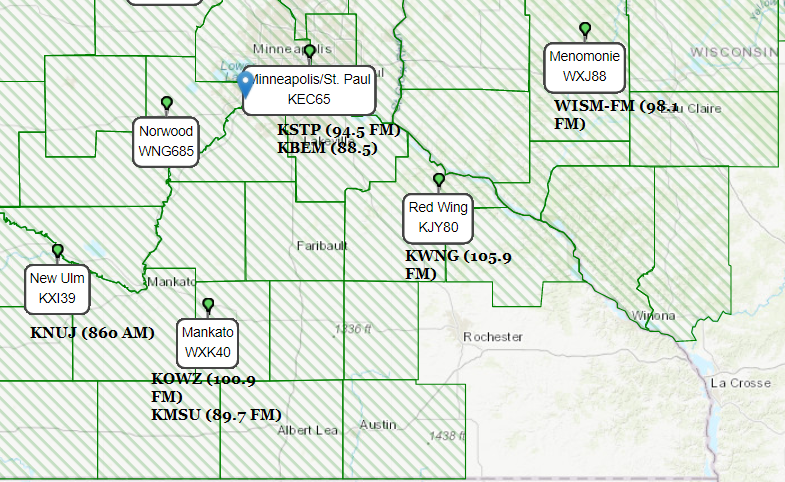
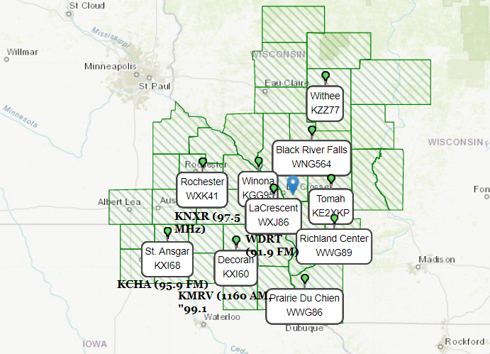
Know where to tune for Emergency Alerts?
Here's a map of area Weather Radio and commercial stations that relay weather/civil alerts.
If you have any questions, feel more than free to ask : )
Always have your Weather Alert radios on!
#MNwx#WIwx#IAwx#Minneapolis#RochMN
***Shelter in Place Warning***
Farmington PD - Shelter in place 188th St. W. and English Ave. We are asking residents to lock their doors and stay inside for an active incident that we are investigating. We will send a notification when it is safe to no longer shelter in place.
***Civil Danger Warning***
Portion of Minneapolis within 5 blocks of 28th st s and Nicollet
Per Minneapolis police avoid the area of Nicollet and 28th St S
#MNwx#EmergencyAlert
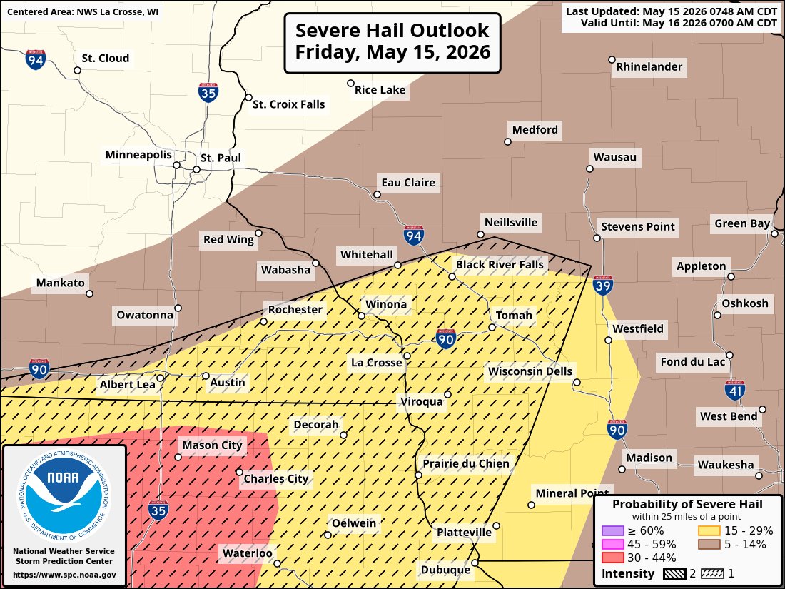
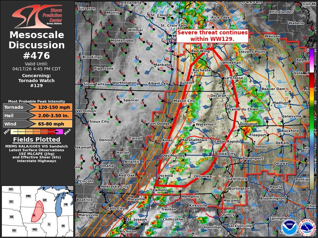
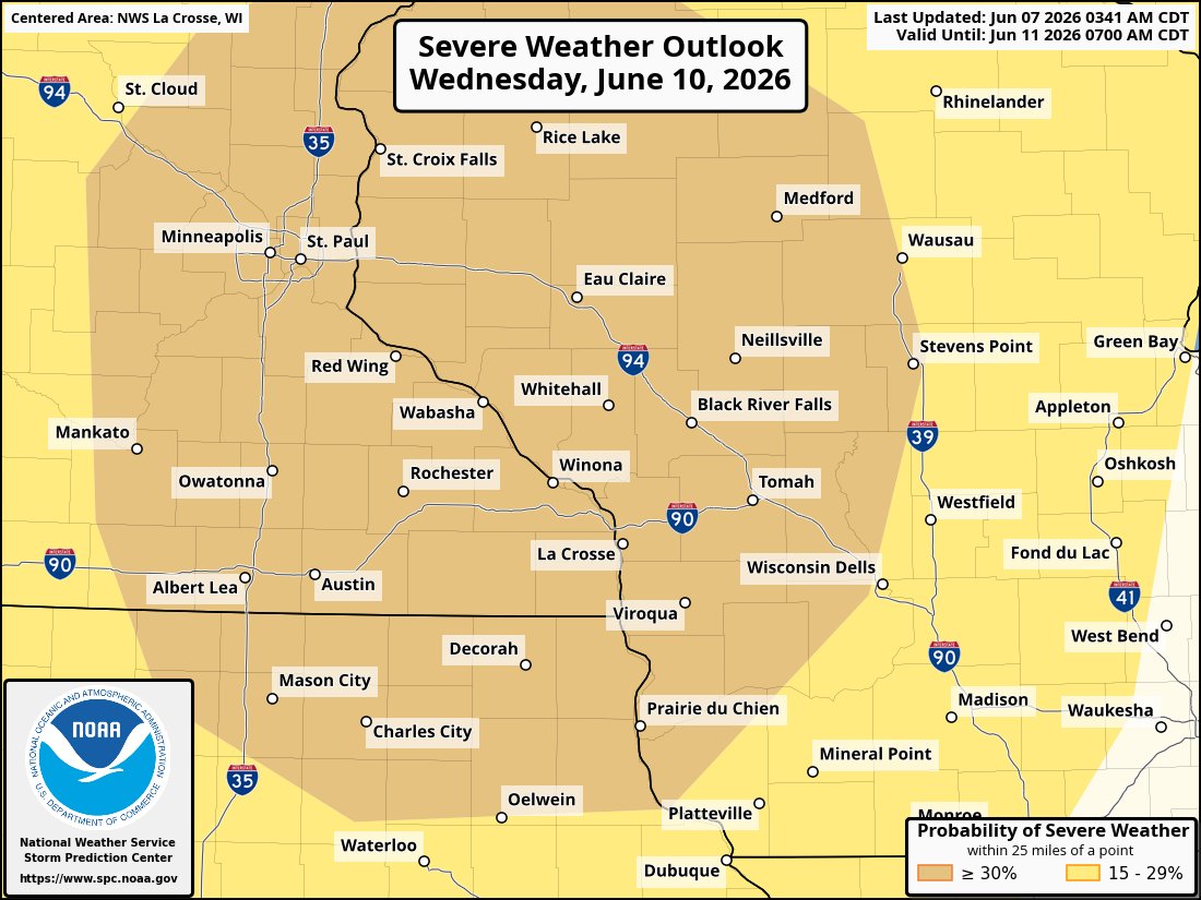
Severe weather, potentially significantly, is becoming increasingly likely Wednesday.
It is too early to determine exact hazards and timing, keep an eye on forecasts from trusted sources.
Our local NWS Offices are @NWSLaCrosse and @NWSTwinCities .
#MNwx#WIwx#IAwx
***Civil Emergency Message***
MISSING PERSON ALERT: 22-year-old white male last seen 5/23/26 in the area wearing a black baseball hat, black T-shirt, and gray sweatpants. If you see anyone matching this description or have information, call 911 immediately.
#MNwx
Tornado watch until 1 AM.
A few tornadoes and a couple intense tornadoes possible, very large, destructive hail is possible as well as strong winds.
Have a tornado plan ready tonight.
#MNwx#WIwx#IAwx
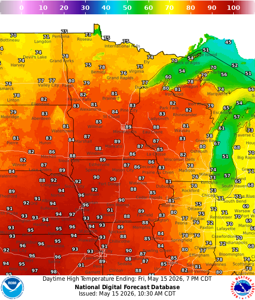
Showers and thunderstorms expected this afternoon and evening.
A strong storm is also possible with chances for large hail the main threat.
This will usher us into a very active stretch of Severe Weather over the next few days.
#MNwx#WIwx#IAwx#RochMN#LaCrosse#Rochester
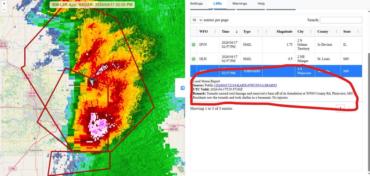
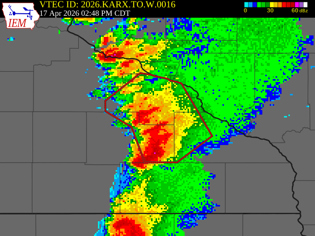
At 333 PM CDT, a confirmed large and extremely dangerous tornado was located near Montana and additional tornadoes could form.
This is a PARTICULARLY DANGEROUS SITUATION. TAKE COVER NOW!
#MNwx#WIwx
NWS La Crosse Notes "A dangerous tornado is likely located near Elgin!"
At 246 PM CDT, tornado producing storms were located along a line extending from near Mazeppa to near Dover, moving northeast at 25 mph.
Weather spotters confirmed tornado. TAKE COVER NOW!
#MNwx
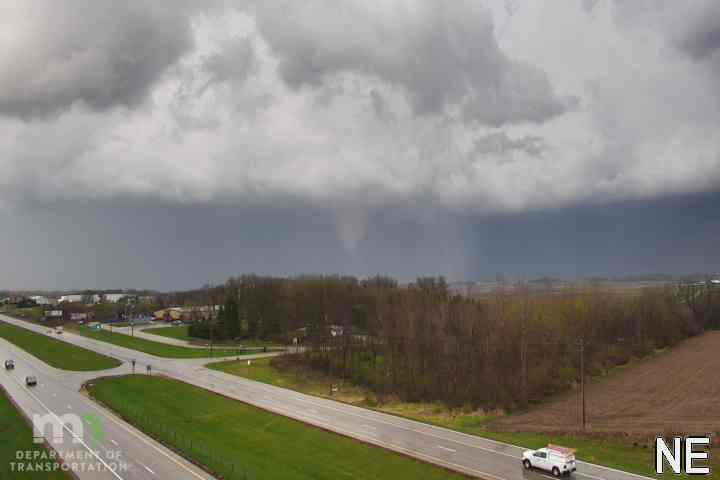
Tornado seen from the @flyrst via MnDOT Cams.
Tornado Warnings must be taken very seriously today. Don't take the chance, take cover IMMEDIATELY if one is issued.
#MNwx#WIwx#IAwx#RochMN#Rochester
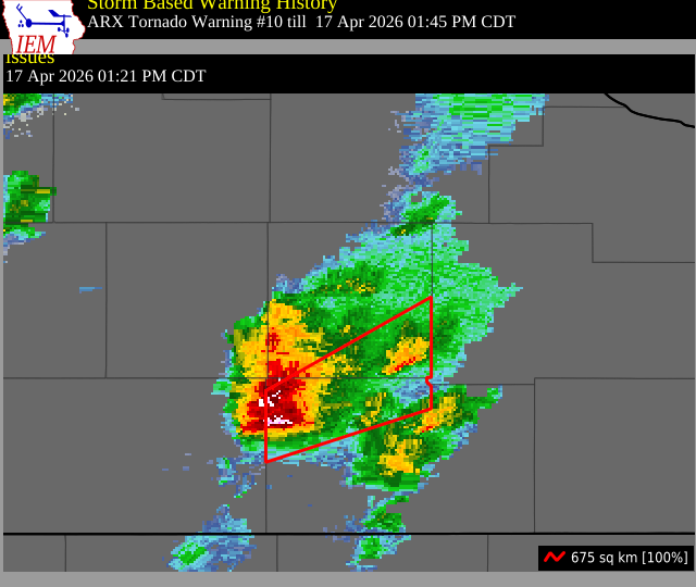
At 236 PM CDT, a severe thunderstorm capable of producing a Tornado and quarter size hail was located near Stewartville, or 13 miles SE of Rochester, moving northeast at 45 mph.
This tornadic thunderstorm will remain over mainly rural areas of northwestern Fillmore.
#MNwx
At 219 PM CDT, a confirmed Damaging tornado and two inch hail was located over Stewartville, or 9 miles south of Rochester, moving northeast at 50 mph.
To repeat, a tornado is on the ground. TAKE COVER NOW!
#MNwx#RochMN#Rochester
***Civil Emergency Message***
Tornado Warning in area of South Rochester and Rochester International Airport. Seek shelter immediately.
Weather spotters confirmed tornado. Multiple tornadoes have been reported with this storm.
#MNwx#RochMN#Rochester
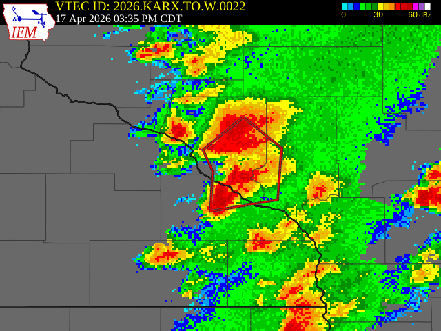
Tornado Warning, including Austin.
At 121 PM CDT, a severe thunderstorm capable of producing a Tornado and quarter size hail was located near Brownsdale, or near Austin, moving northeast at 45 mph.
#MNwx#IAwx
78 at La Crosse, 72 at Albert Lea, and 37 at New Ulm (Bit of a cold front pushing through) at Noon.
Destructive storms remain possible (With possibility of multiple strong tornados) mostly in Wisconsin, many schools and events ending early/cancelled.
#MNwx#WIwx#IAwx#ILwx
At 857 PM CDT, severe thunderstorms capable of producing both tornadoes and extensive straight line wind damage were located near Brownsdale, or 9 miles north of Austin, moving east at 35 mph.
This warning includes Rochester and I-90.
#MNwx#IAwx#RochMN