Note that I will no longer be posting regularly on X after 20 January. The disrespect and disinformation promoted by the owner of this platform is no longer acceptable to me.
I'll continue on BlueSky https://t.co/fGiFhJFsYw and Mastodon.
Summary of rainfall so far this summer. Blue areas are the driest. Some of those areas have only received 1/4 of the normal rainfall which is quite substantial for such a long period (the better part of a season). Note eastern Nfld where there are currently fires. #nswx#nlwx
@danielmullen@MCCCANM Indeed: https://t.co/iI32HMd7Rw
Climate change is enhancing flash floods threat (death & destruction). A comprehensive system includes identification of risk areas (pluvial flood maps), public education, forecast & detection systems (incl AI), and effective alerting.
Note that I will no longer be posting regularly on X after 20 January. The disrespect and disinformation promoted by the owner of this platform is no longer acceptable to me.
I'll continue on BlueSky https://t.co/fGiFhJFsYw and Mastodon.
As a member of the private sector in the weather enterprise, I want to emphasize that reducing support for national meteorological agencies is bad for business. Moreover, weather does not follow borders, so curtailing data collection in one country has global repercussions.
Acknowledging women scientists today #womeninscience, including the many friends and colleagues who collaborate within the Canadian Meteorological and Oceanographic Society @CMOS_SCMO
This is an important post. Weather, water and climate services in Canada and around the world mutually benefit from incredible cooperation. US scientists, including NOAA and the National Weather Service are leaders internationally and friends to us all.
The weather & climate enterprise provides essential services that the public relies upon. We do not yet know the depth of the changes we face, but all have a voice, and we are stronger together than apart.
Read a message from the AMS President: https://t.co/0UuH6wxa1u
@YHZweatherguy Measured 20 cm in city of Saint John as of 6AM.Snow is lighter intensity now.Began late Sunday evening as heavy wet snow,big flakes size of quarter. Like a snow globe. Pretty! Became wind driven powder overnight with 15:1 ratios,with vsbys 0.8km ocnl 1.2km.Accumulated quickly
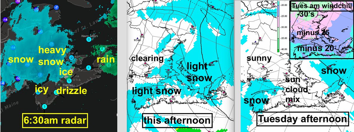
6:30am snowfalls exceeded 15cm S NB. Messy mix along Annapolis Valley thru Truro with drizzle or rain along ATL coast NS.
Precip eases off this am with cold NW winds & onshore light snow this aftn.
Wind chills minus 20's south; minus 30's north Tues am. Onshore snow persists.
“ I knew one day I’d have to watch powerful men burn the world down – I just didn’t expect them to be such losers” Rebecca Shaw https://t.co/vO20s4BZ1a
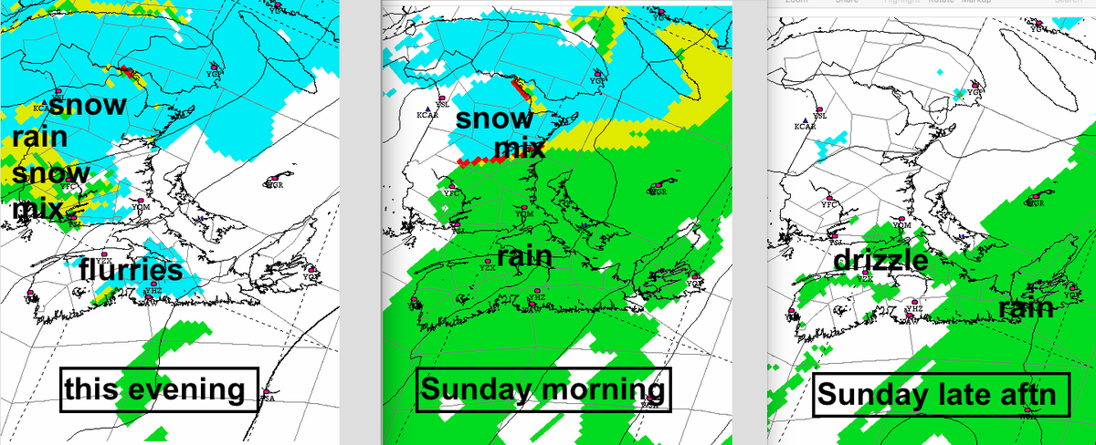
A band of rain (snow north) moving across the Maritimes today (rain tapers off after lunch HFX; after supper CB).
Snow redevelops NB-W PEI & parts N NS tonight with rain further SE. Icy mix near Truro.
Precip tapers off Monday aftn as COLD air invades from NW. Messy roads!
If you’re pondering why people aren’t more concerned about climate change, it’s not complicated.
The oil industry spends $1 billion a year on disinformation.
That buys a lot of confusion - even amongst the educated and intelligent.
All here: https://t.co/VmLl5TxMV5 #LA fires
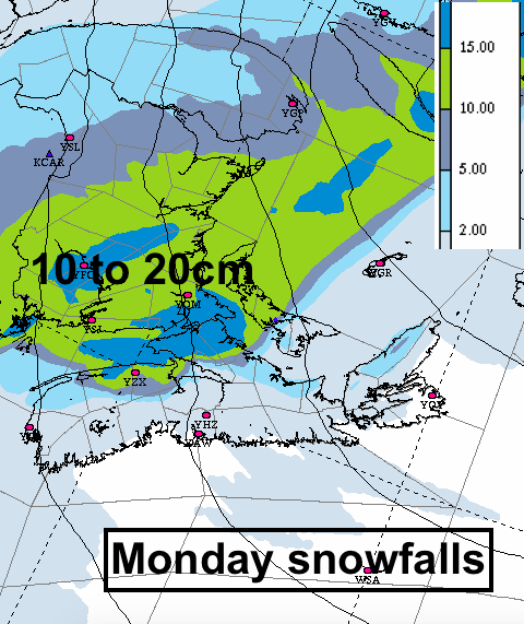
Some consistency now in the Monday snowfall outlooks... the heavier snow threatening all but NW NB, as well Queens & Prince PEI, and a swath across northern parts of NS.
Update in the morning...
Fine today & Saturday.
Rain snow mix moves in Saturday evening changing to rain Sunday then moves off.
Snow moves in Sunday night changes to rain parts of NS Monday then a cold week follows.
Gradual thickening clouds today. Snow moves in tonight changing to rain in southern Maritimes. The rain moves out from W to E Sunday (eve CB). 5-10cm snow N NB; up to 25mm rain Fundy & Atl coasts.
Note: snow develops quickly in NB Sunday eve/night; rain Atl coast (details TBD).