A business consulting firm specialising in Kenyan & US #Bookkeeping, Virtual Assistance, Business Management Consulting & Weather Forecasting Model Analytics
"Hey Maithya. Why is it so cold & cloudy in #Nairobi na hakuna mvua?"
Well, a quick check across the models shows that today's peak daytime temps in #Nairobi at 3PM won't cross 22 degree Celcious, due to dense cloud cover.
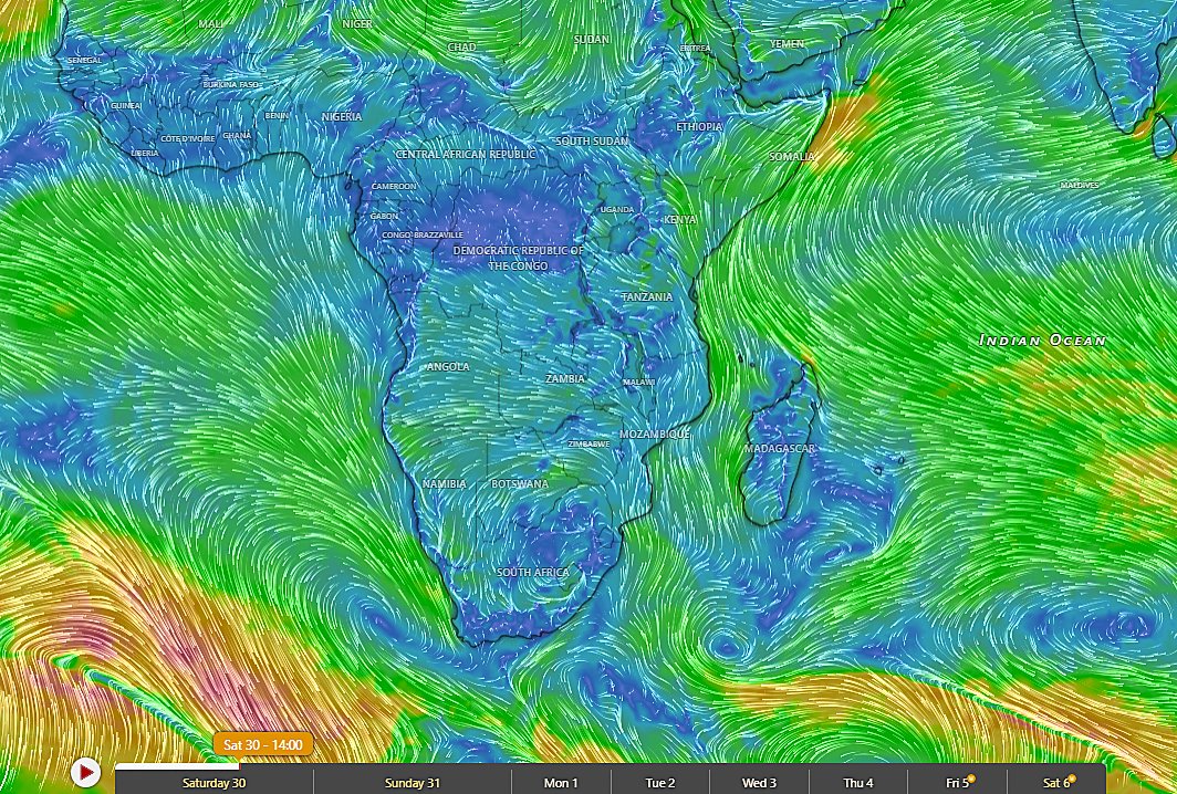
An examination of wind patterns shows a cool stream of dry lower atmospheric continental winds from a cooler Southern Africa region blowing into Kenya through #Mozambique & #Tanzania.
This jet of cool air won't be sustained for long and warm weather will resume in much of KE in the coming days.
The persistent cold season in Kenya is expected to start from mid to late June, after the Southern hemisphere winter solstice.
Consequently, moderate to heavy rains fall in the next two weeks along the entire stretch of the #Kenyan coastal strip all the way from Shimoni to Mombasa to Malindi to Tana Delta to Boni forest in Lamu.
The rains bands in North Coast may push further inland into the Southern parts of Garissa County.
Parts of Lamu County may receive over 220mm of cumulative rainfall within the forecast period , per GFS
The Turkana Jet gets so strong in the next 7 days such that wind gusts may breach 110KM per hour.
Those who drive along the Marsabit-Moyale route will experience some crazy cross winds that could possibly make a car to wobble.
The jet passes through the Turkana channel between Kenya and Ethiopia, making Marsabit the windiest county in KE.
Tells you one of the main factors considered for the location of the Lake Turkana Wind Farm in Loiyangalani
Moderate to heavy rains have fallen in some parts of the #Nairobi Metro area this evening. Heavy rains reported in most of Kiambu county.
It'll rain moderately in Nairobi tomorrow. On Wednesday, the rains may get heavy.
From Thursday, rains recede significantly as the end of the rainy season draws closer.
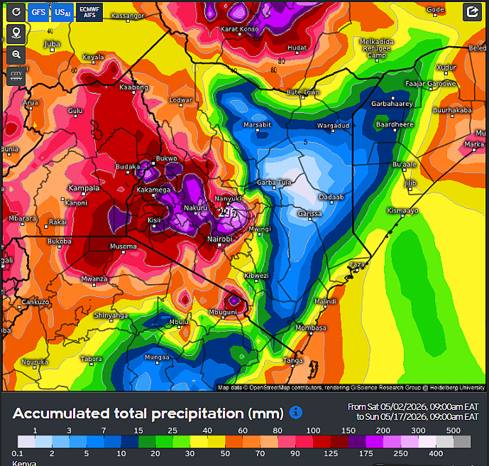
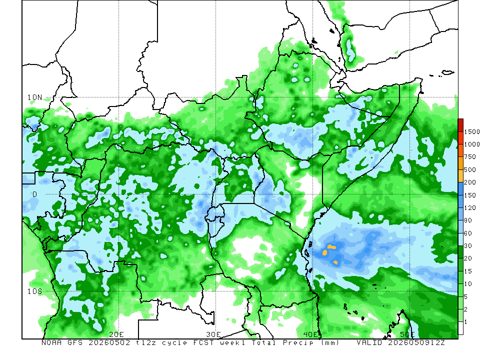
Heavy Rains in most of the Rift & the Central highlands (Upper Tana Catchment Area) in the seven days to 16/05, per GFS rainfall distribution charts
Two weeks precipitation accumulation charts by ECMWF, GFS & US-AI models depict cessation of rains in much of the Coastal region (spare for the areas along the Indian Ocean shoreline), Eastern and North Eastern within the two weeks to mid-May as the lower atmosphere winds in these regions diverge, allowing sinking of upper atmospheric air, due to establishment of the South Western Indian Ocean monsoon winds.
In contrast, heavy disruptive rains continue unabated in most of Central, Mt #Kenya , The Rift, Western & Nyanza Counties. These rains are driven by the ITCZ and enhanced by the recent high amplitude Madden Julian Oscillation wave entering phase 1 & 2, which has ensured sustained westerly wind anomalies from the Congo basin into the Rift, Western & Nyanza. The three best-skilled medium range forecast models are well-aligned in regards to this forecast.
GFS is particularly aggressive, showing over 320mm in Central Rift, ECMWF depicts up to 300mm in mt. Kenya while the US-AI shows heavy rain in Mt Kenya, Elgon, Kilimanjaro.
Likely flash flooding episodes in the Lower Tana Basin, Rift Valley & Nyanza. Mudslides already reported in parts of The Rift & Central.
Folks, we're in May 2026 (obviously). Seasons are about to change.
The South West Indian Ocean Monsoon winds are taking shape, bringing showers to the Coastal strip while marking the imminent end (in a week or two) of the rainy season in Southern, Eastern and North Eastern Kenya.
Lower atmospheric wind patterns show a properly established South West Indian Ocean Monsoon by the third week of May, indicating transportation of moisture from the West #Indian Ocean to the Indian Sub-Continent where the Monsoon rainy season will start in the coming days.
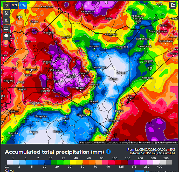
Very heavy rains (up to 350mm) forecast for the whole of Nyanza, Western and much of the Rift in the next two weeks.
This could cause the worst deluge in these regions since the year began
Nyando and Nzoia Rivers about to face a big test. Will their banks hold?
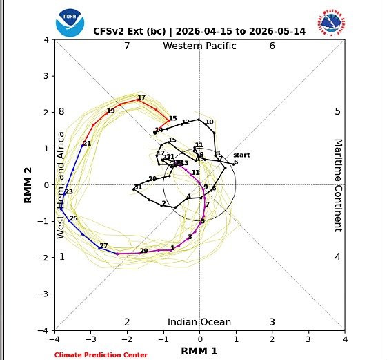
Global models show a high amplitude MJO index entering The Western hemisphere and Africa as well as phase 1 & 2 in the coming days, after lingering in the Pacific Ocean for almost a month.
Australian and Japanese Met models show a high amplitude MJO wave in equatorial Africa in the last week of April into early May.
100-member ECMWF and NOAA CPC's models show a high amplitude MJO eastward pulse in phases 1,2 & 3.
The MJO wave is expected to bring increased atmospheric convection, humidity and cloud formation coupled with the ITCZ hence the improved precipitation performance in eastern Africa
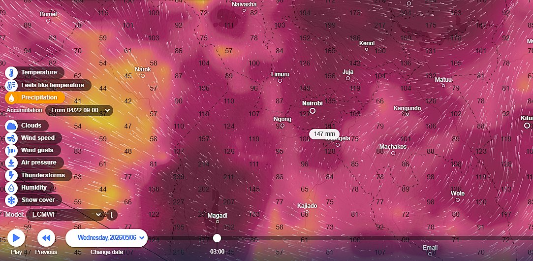
Weather forecasting model output graphics for #Nairobi Metro area #Kenya:
I'm getting a lot of requests from Nairobian to share the outlook for Nairobi. Here it is:
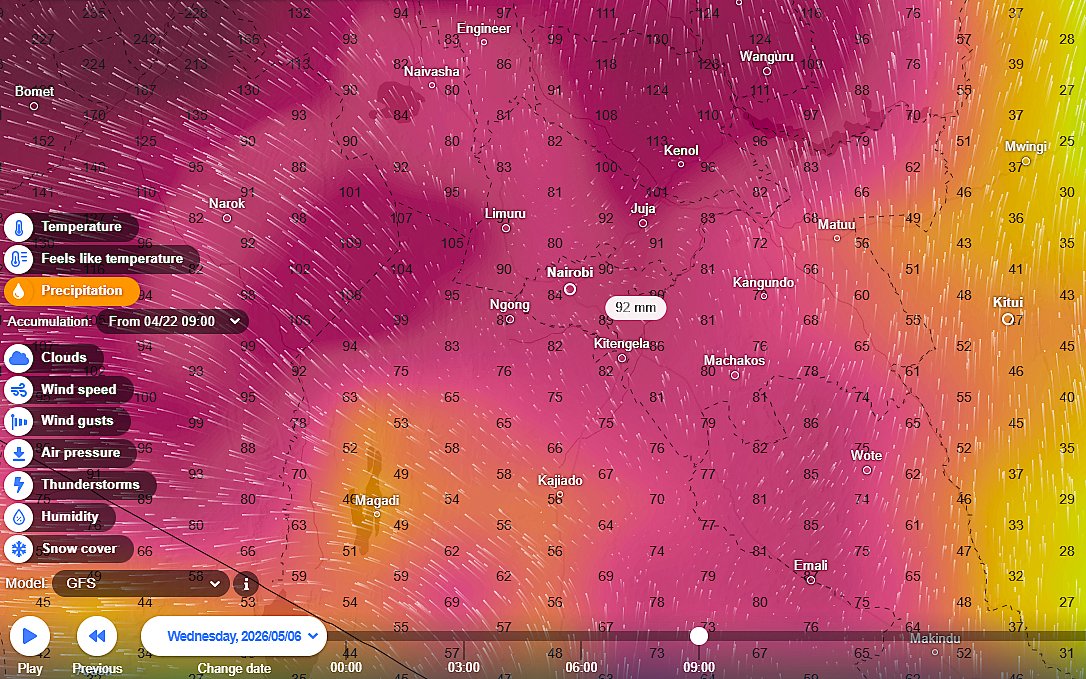
Medium range model forecasts show a comeback of moderate to heavy rainfall in #Nairobi County within the two weeks to 06/05.
GFS model shows over 90mm, while the Euro model depicts over 150mm cumulative rainfall within the forecast period.
Other areas set for heavy rainfall within the larger Metro area include Kajiado North and Muranga County. Much of Kiambu, Machakos gets moderate-to-heavy rainfall depending on location.
The rains begin from this weekend and may get heavy as we get into next week.
⚠️Updated weather forecast for #Nairobi metropolitan area tonight looks scary 😲
Machakos, Nairobi & Murang'a folks take all necessary measures to stay safe
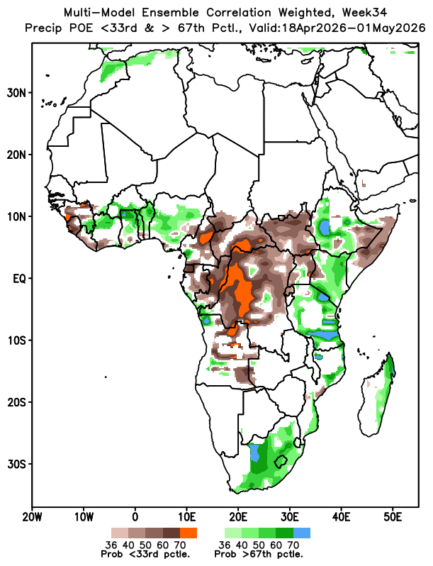
Update: The skill-weighted NMME multimodel-ensemble charts depict slightly-to-highly enhanced rainfall across most of #Kenya in the last ten or so days of April. Between 36%-70% of model simulation observations for KE in that forecast period lie in the upper tercile, indicating wetter-than-normal conditions may prevail. Further updates in the coming days
The peak of the MAM rainy season in #Kenya normally occurs in the last two weeks of April.
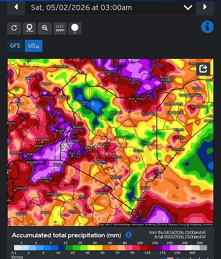
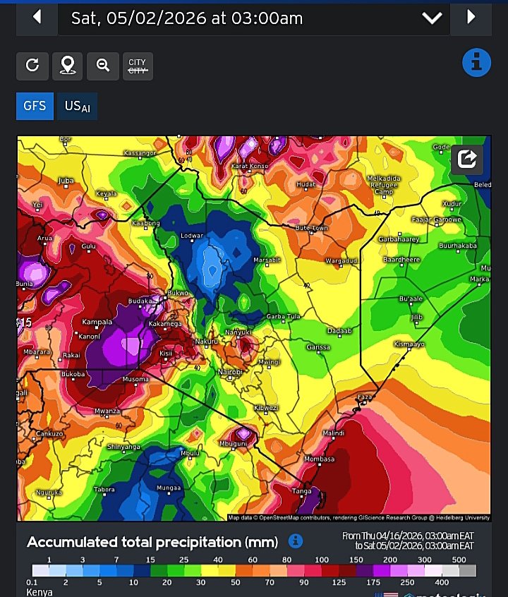
As we enter the second half of the month, medium range weather forecasting models output graphics depict heavy to very heavy rains in most Counties of #Kenya within the two weeks ending 02/05.
GFS ECMWF and the US-AI are in concurrence that heavy rains (up to 350mm in some places) may fall in Western, Nyanza and parts of Central Rift valley within the forecast period. This points to a high likelihood of disruptive rainstorms in these areas.
Central, #Nairobi, Mt Kenya massif, North Eastern, the Coast and Ukambani regions receive moderate to heavy rains in the same period.