Severe Weather Intelligence App. High-resolution radar, AI predictions & forecasts, and second by second lightning detection. Available on iOS and Android.
@TheRealEF4WXnew@MidwestWeathe_r Fortunately to let you know, we do not affiliate with anyone who is against the NWS or SPC. We’re professional and strict when it comes to anything unrelated. We also show NWS warnings and SPC watches. Please give us a try before any judgement. We’re sure you’ll love it.
BIG ANNOUNCEMENT!
We are absolutely thrilled to announce our official partnership with @MidwestWeathe_r (MIDWEST WEATHER)
Together, we’re taking weather tracking to the next level. Through this collaboration, we’ll be expanding the reach of our proprietary lightning and precipitation detection technology, as well as giving more communities access to our comprehensive weather platform.
But it doesn't stop there. We are working hand-in-hand with the incredible team at Midwest Weather to transform how you receive your weather data. Together, we will:
- Deliver better, hyper-accurate forecasts tailored to your region.
- Bring you higher quality, real-time updates so you're never caught off guard.
- Enhance severe weather tracking to maximize safety and preparation times.
- Integrate cutting-edge data directly into the tools you rely on every day.
When it comes to extreme weather, every second counts. We can't wait to combine our tech with Midwest Weather's local expertise to keep you safer and more informed than ever before.
Stay tuned for further updates.
I'm not even sure where to start, but expect a lot of posts today given that there is so much to update you on…
First things first, we will be going over the El Niño situation, followed by many, many other topics that I know you guys are dying for me to talk about… confirmed via DMs…
Current Update on El Niño:
We are already transitioning from a neutral phase into the starting phases of El Niño.
The Niño 3.4 region, which is how we measure sea surface temperatures (SST), has already reached +0.9°C. It is continuing to rise and will likely hit +1.5°C within months. Weather patterns are already starting to show changes, and they will continue to shift rapidly as these temperatures continue to rise…
Impacts can already be seen:
🌀 A very active hurricane season across the Pacific.
🌬️ A split jet stream, with the southern branch currently dipping into our area and the northern branch staying further north.
We will continue to monitor further impacts. As bigger updates come out WITHOUT THE HYPE I will be sure to share them with you all…
🌀 TROPICS ARE BECOMING ACTIVE 🌀
The Pacific tropics are waking up early, a clear sign of how busy this summer could get. Keep in mind it is only the end of May.
Once steering patterns lock in, they can pull these storms that form west of Mexico northward. These are major moisture producers that we will watch closely for impacts like gusty winds, heavy rain, and lightning.
🛰️ On the Satellite:
A large messy area of storms has formed far southwest of Mexicos Baja Peninsula. Conditions are ripe for slow growth, and it will likely strengthen into a tropical depression by midweek. It is currently moving west northwest at 10 to 15 mph across the eastern Pacific.
Scattered Severe T-Storms Possible Across the Pacific Northwest on May 28th, 2026
Damaging winds large hail and isolated tornadoes are possible this afternoon through early evening across northeastern Oregon southeastern Washington and western Idaho
Track the storms, lightning and get real time updates directly on the zonewatch app now
Trying to be a successful content creator today is the most discouraging feeling if you allow it. "Do this, no don't do that. Your work is shit. You're ruining for the real OGs. You don't have the right gear. You're a loser."
What it comes down to is self worth. Understand that the rest of it is noise. Until you break free from the self condemnation, you'll never find success out there. It has to... it absolutely has to start from within.
ELECTRIC GLOW ⚡️: Lightning and thunderous roars ignited the sky over Quanah, Texas, Friday night. Watch as the internal glow pulses through pronounced clouds rolling across the area.
⚡ 2.58k lightning strikes in just 5 minutes (over 500 strikes per minute!).
Tracking this intense line of storms pushing through southeast Texas with absolute precision. Watch every single strike plot second-by-second, live as it happens. Don't settle for delayed updates get real-time lightning detection, only on ZoneWatch.
Check it out at https://t.co/MHz6coRKVt
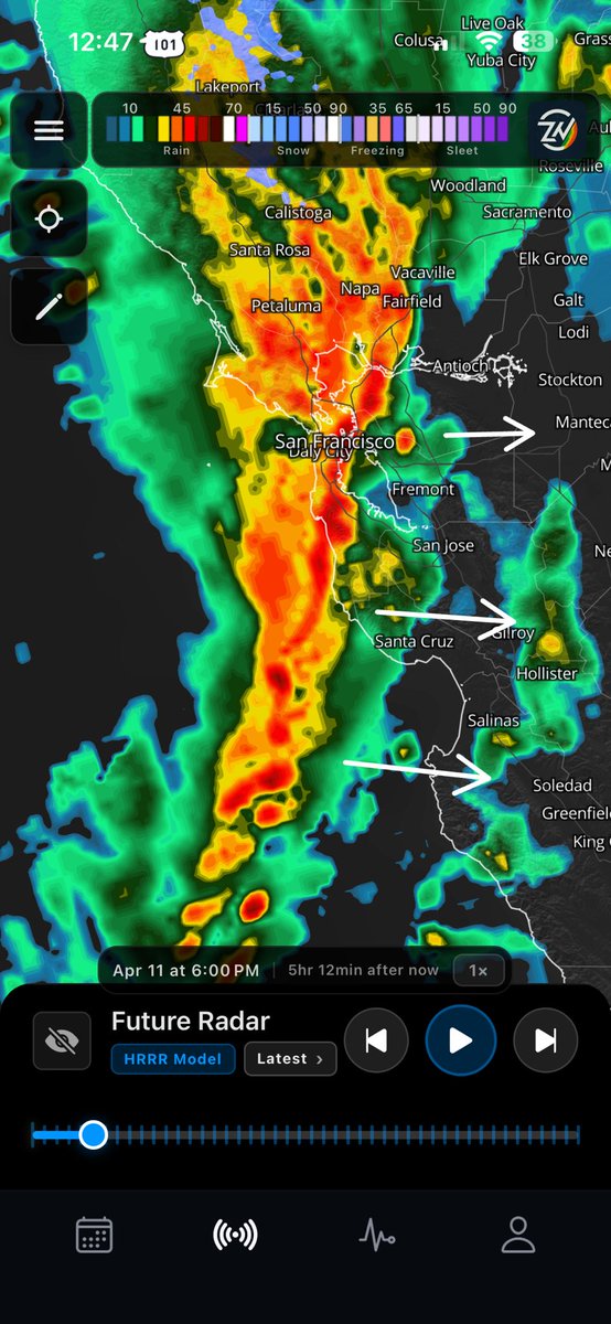
⚠️ STRONG BAND OF STORMS EXPECTED TO SLAM THE BAY AREA TONIGHT
Summary: A powerful line of heavy rain and intense storms will push onshore later today, taking direct aim at the Bay Area down through the Central Coast.
Impact: Expect torrential downpours, localized roadway flooding, and very dangerous driving conditions for the evening commute. Convective storms could also bring frequent lightning as well.
⏰ Timing:
Storms to slam the coast and move inland right around 6:00 PM PT tonight.
Track the exact timing for your city on the ZoneWatch app! Image from future radar HRRR.
⚠️ SoCal Sunday Morning Rain Update ⚠️
The system that hit NorCal is moving south, but as ZoneWatch predicted, it’s underperforming down here. Very low thunderstorm risk likely just showers, but expect slick roads!
⏰ Sunday Estimated Timing:
📍 Ventura: 3:00 AM PT
📍 LA / Orange County: 6:00 AM PT
📍 San Diego: Noon PT
Scattered showers will linger on and off through Monday morning.
📱 App News: A massive update featuring ZWCast drops this Thursday! For exact timing or other regions, check the ZoneWatch app.
🚨 Rain Coming to LA DT
Heads up! Our proprietary ZoneWatch tracking shows precipitation picking up over the weekend. Here is the breakdown for the next 48 hours.
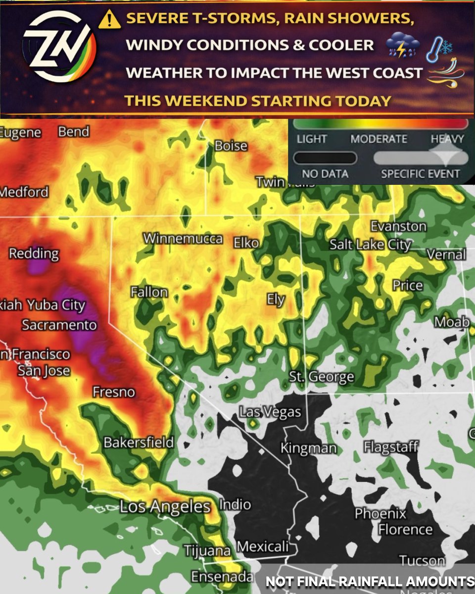
⚠️ Severe T-Storms, Rain Showers, Windy Conditions and Cooler Weather to Impact the West Coast this Weekend Starting Today
A potent upper-level trough and cut-off low are clashing with subtropical moisture, bringing a highly dynamic weekend of weather!
⛈️ NorCal: Scattered Severe T-Storms today (hit or miss)
🌨️ Sierras: Heavy snow dropping to 4,500ft tonight
☔ WA/OR/ID: Coastal rain & mountain snow
💨 NV/UT: 40-50mph gusts & blowing dust
🌧️ SoCal: Scattered weekend showers (no severe risk) Sunday watch for t-storm risk especially morning hours🏜️ AZ/NM: Dry/windy today, light showers by Sunday also monitoring t-storm risk
📱 Track exact timing for your area on the ZoneWatch app!
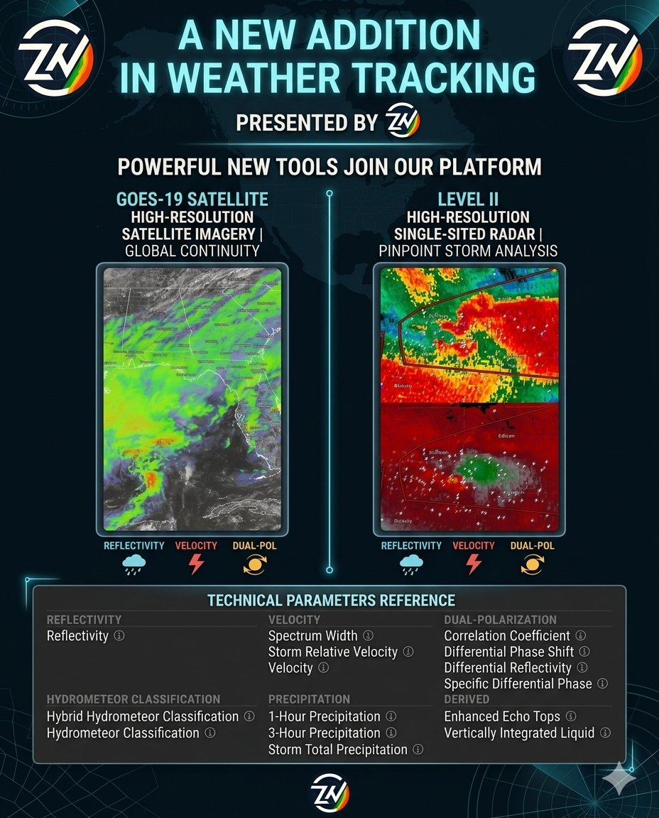
🚨 COMING SOON: Level II High Resolution Radar & More
We’re unlocking the most powerful tools in meteorology used by pros. Stay ahead of the storm with:
📡 Level II High-Res Radar: Go microscopic. Track rotation, hail, and tornado debris with single-site precision.
🛰️ GOES-19 Satellite: Lightning-fast imagery & the new CCOR-1 solar sensor.
Whether you're a pro or just staying safe, this is a total game-changer.